Moutier-Malcard
| Moutier-Malcard | |
|---|---|
| Commune | |
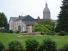 The centre of Moutier-Malcard | |
 Moutier-Malcard Location within Nouvelle-Aquitaine region  Moutier-Malcard | |
| Coordinates: 46°23′41″N 1°56′45″E / 46.3947°N 1.9458°ECoordinates: 46°23′41″N 1°56′45″E / 46.3947°N 1.9458°E | |
| Country | France |
| Region | Nouvelle-Aquitaine |
| Department | Creuse |
| Arrondissement | Guéret |
| Canton | Bonnat |
| Intercommunality | CC Portes de la Creuse en Marche |
| Government | |
| • Mayor (2008–2014) | Jean-Marie Moutard |
| Area1 | 25.81 km2 (9.97 sq mi) |
| Population (2008)2 | 543 |
| • Density | 21/km2 (54/sq mi) |
| Time zone | UTC+1 (CET) |
| • Summer (DST) | UTC+2 (CEST) |
| INSEE/Postal code | 23139 /23220 |
| Elevation |
262–433 m (860–1,421 ft) (avg. 363 m or 1,191 ft) |
|
1 French Land Register data, which excludes lakes, ponds, glaciers > 1 km2 (0.386 sq mi or 247 acres) and river estuaries. 2 Population without double counting: residents of multiple communes (e.g., students and military personnel) only counted once. | |
Moutier-Malcard is a commune in the Creuse department in the Nouvelle-Aquitaine region in central France.
Geography
A farming area comprising the village and several hamlets situated some 15 miles (24 km) north of Guéret at the junction of the D46, D56 and the D990 roads. The Petite Creuse river forms the southern boundary of the commune.
Population
| Historical population | ||
|---|---|---|
| Year | Pop. | ±% |
| 1962 | 736 | — |
| 1968 | 865 | +17.5% |
| 1975 | 747 | −13.6% |
| 1982 | 678 | −9.2% |
| 1990 | 573 | −15.5% |
| 1999 | 514 | −10.3% |
| 2008 | 543 | +5.6% |
Sights
- The church of St. Martin, dating from the twelfth century.
- A fifteenth-century donjon and stone cross.
See also
References
External links
- Moutier-Malcard on the Quid website (in French)
| Wikimedia Commons has media related to Moutier-Malcard. |
This article is issued from
Wikipedia.
The text is licensed under Creative Commons - Attribution - Sharealike.
Additional terms may apply for the media files.