Blessac
| Blessac | ||
|---|---|---|
| Commune | ||
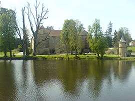 Chateau | ||
| ||
 Blessac Location within Nouvelle-Aquitaine region  Blessac | ||
| Coordinates: 45°57′34″N 2°07′39″E / 45.9594°N 2.1275°ECoordinates: 45°57′34″N 2°07′39″E / 45.9594°N 2.1275°E | ||
| Country | France | |
| Region | Nouvelle-Aquitaine | |
| Department | Creuse | |
| Arrondissement | Aubusson | |
| Canton | Aubusson | |
| Intercommunality | CC Creuse Grand Sud | |
| Government | ||
| • Mayor (2008–2014) | Robert Cuisset | |
| Area1 | 17.75 km2 (6.85 sq mi) | |
| Population (2008)2 | 521 | |
| • Density | 29/km2 (76/sq mi) | |
| Time zone | UTC+1 (CET) | |
| • Summer (DST) | UTC+2 (CEST) | |
| INSEE/Postal code | 23024 /23200 | |
| Elevation |
406–665 m (1,332–2,182 ft) (avg. 550 m or 1,800 ft) | |
|
1 French Land Register data, which excludes lakes, ponds, glaciers > 1 km2 (0.386 sq mi or 247 acres) and river estuaries. 2 Population without double counting: residents of multiple communes (e.g., students and military personnel) only counted once. | ||

Blessac is a commune in the Creuse department in the Nouvelle-Aquitaine region in central France.
Geography
An area of lakes, forestry and farming comprising the village and some hamlets situated just 4 miles (6.4 km) west of Aubusson, in the Creuse River valley and at the junction of the D17, D7 and the D941 roads.
Population
| Historical population | ||
|---|---|---|
| Year | Pop. | ±% |
| 1962 | 292 | — |
| 1968 | 316 | +8.2% |
| 1975 | 342 | +8.2% |
| 1982 | 411 | +20.2% |
| 1990 | 495 | +20.4% |
| 1999 | 488 | −1.4% |
| 2008 | 521 | +6.8% |
Sights
See also
References
External links
- Blessac on the Quid website (in French)
| Wikimedia Commons has media related to Blessac. |
This article is issued from
Wikipedia.
The text is licensed under Creative Commons - Attribution - Sharealike.
Additional terms may apply for the media files.