Dun-le-Palestel
| Dun-le-Palestel | ||
|---|---|---|
| Commune | ||
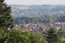 The village from the Chabannes Wood | ||
| ||
 Dun-le-Palestel Location within Nouvelle-Aquitaine region  Dun-le-Palestel | ||
| Coordinates: 46°18′22″N 1°40′00″E / 46.3061°N 1.6667°ECoordinates: 46°18′22″N 1°40′00″E / 46.3061°N 1.6667°E | ||
| Country | France | |
| Region | Nouvelle-Aquitaine | |
| Department | Creuse | |
| Arrondissement | Guéret | |
| Canton | Dun-le-Palestel | |
| Intercommunality | CC Monts et Vallées Ouest Creuse | |
| Government | ||
| • Mayor (2008–2014) | Laurent Daulny | |
| Area1 | 9.81 km2 (3.79 sq mi) | |
| Population (2008)2 | 1,160 | |
| • Density | 120/km2 (310/sq mi) | |
| Time zone | UTC+1 (CET) | |
| • Summer (DST) | UTC+2 (CEST) | |
| INSEE/Postal code | 23075 /23800 | |
| Elevation |
294–507 m (965–1,663 ft) (avg. 366 m or 1,201 ft) | |
|
1 French Land Register data, which excludes lakes, ponds, glaciers > 1 km2 (0.386 sq mi or 247 acres) and river estuaries. 2 Population without double counting: residents of multiple communes (e.g., students and military personnel) only counted once. | ||
.svg.png)
Dun-le-Palestel is a commune in the Creuse department in the Nouvelle-Aquitaine region in central France.
Geography
A farming and light industrial village situated some 15 miles (24 km) northwest of Guéret at the junction of the D913, D44, D5 and the D951 roads.
Population
| Historical population | ||
|---|---|---|
| Year | Pop. | ±% |
| 1962 | 1,201 | — |
| 1968 | 1,260 | +4.9% |
| 1975 | 1,330 | +5.6% |
| 1982 | 1,293 | −2.8% |
| 1990 | 1,203 | −7.0% |
| 1999 | 1,106 | −8.1% |
| 2008 | 1,160 | +4.9% |
Sights
- The church of Notre-Dame, built between 1905 and 1908.[1]
- The Lavoir of Dunet where the residents of the village washed their linens before the invention of the washing machine.
- The portal of the old church, dating from the thirteenth century.
- The war memorial.
- Vestiges of the moat of a castle.
- A dolmen known as the Pierre Eubeste, at La Valette.
See also
References
External links
| Wikimedia Commons has media related to Dun-le-Palestel. |
- Official website of Dun-le-Palestel (in French)
- Dun-le-Palestel on the Quid website (in French)
This article is issued from
Wikipedia.
The text is licensed under Creative Commons - Attribution - Sharealike.
Additional terms may apply for the media files.