Kitaakita
| Kitaakita 北秋田市 | |||
|---|---|---|---|
| City | |||
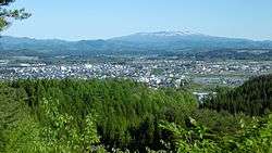 Panorama view of downtown Kitaakita | |||
| |||
 Location of Kitaakita in Akita Prefecture | |||
 Kitaakita | |||
| Coordinates: 40°13′33.7″N 140°22′14.9″E / 40.226028°N 140.370806°ECoordinates: 40°13′33.7″N 140°22′14.9″E / 40.226028°N 140.370806°E | |||
| Country | Japan | ||
| Region | Tōhoku | ||
| Prefecture | Akita Prefecture | ||
| Government | |||
| • -Mayor | Eiko Tsuya <津谷永光> (from April 2009) | ||
| Area | |||
| • Total | 1,152.76 km2 (445.08 sq mi) | ||
| Population (September 2015) | |||
| • Total | 33,064 | ||
| • Density | 28.7/km2 (74/sq mi) | ||
| Time zone | UTC+9 (Japan Standard Time) | ||
| City symbols | |||
| • Tree | Beech | ||
| • Flower | Hydrangea | ||
| • Bird | Black woodpecker | ||
| Phone number | 0186-62-1111 | ||
| Address | Hanazono-chō 19-1, Kitaakita-shi, Akita-ken 018-3392 | ||
| Website | http://www.city.kitaakita.akita.jp/ | ||


Kitaakita (北秋田市 Kitaakita-shi) is a city located in Akita Prefecture, Japan.
As of September 2015, the city had an estimated population of 33,054, and a population density of 28.7 persons per km2. The total area is 1,152.76 square kilometres (445.08 sq mi).
Geography
Kitaakita is located in the mountains of northeastern Akita Prefecture, with the Ou Mountains on the east. Part of the city is within the borders of the Towada-Hachimantai National Park. Much of the city area is covered in forest. Due to its inland location, the city is noted for its heavy snowfall in winter.
Neighboring municipalities
Climate
Kitaakita has a humid continental climate (Köppen climate classification Dfa) with large seasonal temperature differences, with warm to hot (and often humid) summers and cold (sometimes severely cold) winters. Precipitation is significant throughout the year, but is heaviest from August to October.
History
The area of present-day Kitaakita was part of ancient Dewa Province. During the Edo period, the area came under the control of the Satake clan, who ruled the northern third of the province from Kubota Domain. After the start of the Meiji period, the area became part of Kitaakita District, Akita Prefecture in 1878.
The modern city of Kitaakita was established on March 22, 2005, from the merger of the towns of Aikawa, Ani, Moriyoshi and Takanosu (all from Kitaakita District).
Economy
The economy of Kitaakita is based on agriculture, forestry and seasonal tourism.
Education
- Akita University – Kitaakita branch campus
- Kitaakita has 11 elementary schools, five middle schools and one high school, as well as one special education school.
Transportation
Airport
Railway
- JR East - Ou Main Line
- Akita Nairiku Jūkan Railway - Akita Nairiku Line
- Takanosu - Nishi-Takanosu - Ogata - Ōnodai - Aikawa - Kamisugi - Yonaizawa - Katsurase - Ani-Maeda - Maeda-Minami - Kobuchi - Aniai - Arase - Kayakusa - Okashinai - Iwanome - Hitachinai - Okuani - Ani-Matagi
Highway
Local attractions
- Yasu Falls – one of the Japan's Top 100 Waterfalls
- Isedōtai site – a Jōmon period archaeological site and National Historic Monument[1]
Sister city relations

Noted people from Kitaakita
- Takekaze Akira – sumo wrestler
- Tamezō Narita – musician
- Daito Takahashi – Olympic ski jumper
- Norihito Kobayashi – Olympic ski jumper
- Yūsuke Minato – Olympic ski jumper
- Fuyuko Suzuki – Olympic Biathlon athlete
References
- ↑ "Isedotai Site". Jomon Archaeological Sites in Hokkaido and Northern Tohoku. Jomon Japan. 2015. Retrieved 23 December 2015.
External links
| Wikimedia Commons has media related to Kitaakita, Akita. |
- Official Website (in Japanese)
| Core city | ||
|---|---|---|
| Cities | ||
| Districts | ||