Kantō region
| Kantō region 関東地方 | |
|---|---|
| Region | |
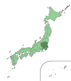 The Kantō region in comparison to the rest of Japan | |
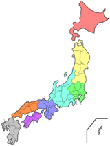
 Closeup map of the areas within the Kantō region | |
| Area | |
| • Total | 32,423.90 km2 (12,518.94 sq mi) |
| Population (October 1, 2017) | |
| • Total | 43,284,547 |
| • Density | 1,300/km2 (3,500/sq mi) |
| GDP (nominal; 2012)[1][2] | |
| • Total | $2.5 trillion |
| • Per capita | $60,000 |
| Time zone | UTC+9 (JST) |
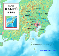
The Kantō region (関東地方 Kantō-chihō) is a geographical area of Honshu, the largest island of Japan.[3] The region includes the Greater Tokyo Area and encompasses seven prefectures: Gunma, Tochigi, Ibaraki, Saitama, Tokyo, Chiba, and Kanagawa. Within its boundaries, slightly more than 45 percent of the land area is the Kantō Plain. The rest consists of the hills and mountains that form the land borders. According to the official census on October 1, 2010 by the Japan Statistics Bureau, the population was 42,607,376,[4] amounting to approximately one third of the total population of Japan.
History
The heartland of feudal power during the Kamakura period and again in the Edo period, Kantō became the center of modern development. Within the Greater Tokyo Area and especially the Tokyo-Yokohama metropolitan area, Kantō houses not only Japan's seat of government but also the nation's largest group of universities and cultural institutions, the greatest population, and a large industrial zone. Although most of the Kantō plain is used for residential, commercial, or industrial construction, it is still farmed. Rice is the principal crop, although the zone around Tokyo and Yokohama has been landscaped to grow garden produce for the metropolitan market.
A watershed moment of Japan's modern history took place in the late Taisho period: the Great Kantō earthquake of 1923. The quake, which claimed more than 100,000 lives and ravaged the Tokyo and Yokohama areas, occurred at a time when Japan was still reeling from the economic recession in reaction to the high-flying years during World War I.
Operation Coronet, part of Operation Downfall, the proposed Allied invasion of Japan during World War II, was scheduled to land at the Kantō plain. Most of the United States military bases on the island of Honshū are situated on the Kantō plain. These include Naval Air Facility Atsugi, Yokota Air Base, Yokosuka Naval Base, and Camp Zama.
The name Kantō literally means "East of the Barrier". The name Kantō is nowadays generally considered to mean the region east (東) of the Hakone checkpoint (関所). An antonym of Kantō, "West of the Barrier" means Kansai region, which lies western Honshu and was the center of feudal Japan.
After the Great Kantō earthquake many people in Kantō started creating art with different varieties of colors. They made art of earthquake and small towns to symbolize the small towns destroyed in the quake.

Subdivisions
North and South
The most often used subdivision of the region is dividing it to "North Kantō" (北関東 Kita-Kantō), consisting of Ibaraki, Tochigi, and Gunma Prefectures, and "South Kantō" (南関東 Minami-Kantō), consisting of Saitama (sometimes classified North), Chiba, the Tokyo Metropolis (sometimes singulated), and Kanagawa Prefectures. South Kantō is often regarded as synonymous with the Greater Tokyo Area. As part of Japan's attempts to predict earthquakes, an area roughly corresponding to South Kantō has been designated an 'Area of Intensified Observation' by the Coordinating Committee for Earthquake Prediction.[5]
The Japanese House of Representatives' divides it into the North Kantō (北関東 Kita-Kantō) electorate which consists of Ibaraki, Tochigi, Gunma and Saitama Prefectures, Tokyo electorate, and the South Kantō (南関東 Minami-Kantō) electorate which consists of Chiba, Kanagawa and Yamanashi Prefectures. (Note that Yamanashi is out of Kantō region in the orthodox definition.)
Keirin's South Kantō (南関東 Minami-Kantō) consists of Chiba, Kanagawa and Shizuoka Prefectures.
East and West
This division is not often but sometimes used.
- East Kantō (東関東 Higashi-Kantō): Ibaraki, Tochigi and Chiba Prefectures.
- West Kantō (西関東 Nishi-Kantō): Gunma, Saitama, Tokyo, Kanagawa (and sometimes Yamanashi) Prefectures.
Inland and Coastal
This division is sometimes used in economics and geography. The border can be modified if the topography is taken for prefectural boundaries.
- Inland Kantō (関東内陸部 Kantō nairiku-bu): Tochigi, Gunma, Saitama (and sometimes Yamanashi) Prefectures.
- Coastal Kantō (関東沿岸部 Kantō engan-bu): Ibaraki, Chiba, Tokyo and Kanagawa Prefectures.
Greater Kantō
The Japanese national government defines the National Capital Region (首都圏 Shuto-ken) as Kantō region plus Yamanashi Prefecture. Japan's national public broadcaster NHK uses Kantō-kō-shin-etsu (関東甲信越) involving Yamanashi, Nagano and Niigata Prefectures for regional programming and administration.
Cities
The Kantō region is the most highly developed, urbanized, and industrialized part of Japan. Tokyo and Yokohama form a single industrial complex with a concentration of light and heavy industry along Tokyo Bay. Other major cities in the area include Kawasaki (in Kanagawa Prefecture); Saitama (in Saitama Prefecture); and Chiba (in Chiba Prefecture). Smaller cities, farther away from the coast, house substantial light and automotive industries. The average population density reached 1,192 persons per square kilometre in 1991.
See also
- Geography of Japan
- Kantō dialect
- Kantō Fureai Trail, aka Capital Region Nature Trail, a collection of hiking trails circumnavigating the entire Kantō Region
Notes
- ↑ "International comparison of GDP of Japan's Prefectures: Tokyo's GDP is bigger than Indonesia's?! - Blog". realestate.co.jp. 13 August 2015. Archived from the original on 1 May 2018. Retrieved 1 May 2018.
- ↑ "Archived copy". Archived from the original on 2015-03-16. Retrieved 2015-11-01.
- ↑ Nussbaum, Louis-Frédéric. (2005). "Kantō" in Japan Encyclopedia, pp. 478-479, p. 478, at Google Books
- ↑ "政府統計の総合窓口". E-stat.go.jp. Archived from the original on 2011-10-04. Retrieved 2012-12-31.
- ↑ Avances en prevención de desastres sísmicos en Japón. Outline of countermeasures for the Tōkai earthquake (Section B) Archived 2011-07-20 at the Wayback Machine. N Honda, published March 1994, accessed 2011-03-25
References
| Wikimedia Commons has media related to Kantō region. |
- Nussbaum, Louis-Frédéric and Käthe Roth. (2005). Japan encyclopedia. Cambridge: Harvard University Press. ISBN 978-0-674-01753-5; OCLC 58053128
![]()