Ehime Prefecture
| Ehime Prefecture 愛媛県 | |||
|---|---|---|---|
| Prefecture | |||
| Japanese transcription(s) | |||
| • Japanese | 愛媛県 | ||
| • Rōmaji | Ehime-ken | ||
| |||
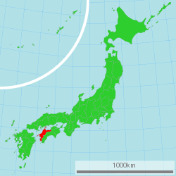 | |||
| Country | Japan | ||
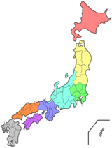
| Region | Shikoku | ||
| Island | Shikoku | ||
| Capital | Matsuyama | ||
| Government | |||
| • Governor | Tokihiro Nakamura (since December 2010) | ||
| Area | |||
| • Total | 5,676.44 km2 (2,191.69 sq mi) | ||
| Area rank | 26th | ||
| Population (February 1, 2018) | |||
| • Total | 1,360,507 | ||
| • Rank | 27th | ||
| • Density | 239.76/km2 (621.0/sq mi) | ||
| ISO 3166 code | JP-38 | ||
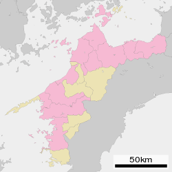
| Districts | 7 | ||
| Municipalities | 20 | ||
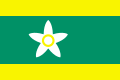
| Flower | Satsuma mandarin (Citrus unshiu)[1] | ||
| Tree | Pine (Pinus)[1] | ||
| Bird | Japanese robin (Erithacus akahige)[1] | ||
| Fish | Red sea bream (Pagrus major)[1] | ||
| Website |
www | ||

Ehime Prefecture (愛媛県 Ehime-ken) is a prefecture in northwestern Shikoku, Japan.[2] The capital is Matsuyama.[3]
History
Until the Meiji Restoration, Ehime Prefecture was known as Iyo Province.[4] Since before the Heian period, the area was dominated by fishermen and sailors who played an important role in defending Japan against pirates and Mongolian invasions.
After the Battle of Sekigahara, the Tokugawa shōgun gave the area to his allies, including Katō Yoshiaki who built Matsuyama Castle, forming the basis for the modern city of Matsuyama.
The name Ehime comes from the kuniumi part of the Kojiki where Iyo Province is mythologically named Ehime, "lovely princess".[5]
In 2012, a research group from the University of Tokyo and Ehime University said they had discovered rare earth deposits in Matsuyama.[6]
Geography
Located in the northwestern part of Shikoku, Ehime faces the Seto Inland Sea to the north and is bordered by Kagawa and Tokushima in the east and Kōchi in the south.
The prefecture includes both high mountains in the inland region and a long coastline, with many islands in the Seto Inland Sea. The westernmost arm of Ehime, the Sadamisaki Peninsula, is the narrowest peninsula in Japan.
As of April 1, 2012, 7% of the total land area of the prefecture was designated as Natural Parks, namely the Ashizuri-Uwakai and Setonaikai National Parks; Ishizuchi Quasi-National Park; and seven Prefectural Natural Parks.[7]
Cities
City Town
_in_2010-9-6_No%2C3.JPG)
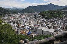
Eleven cities are located in Ehime Prefecture:
Towns and villages
These are the towns in each district:
|
|
|
|
1.JPG)
Mergers
Former districts:
- Uwa District (historical)
- Uma District
- Shūsō District
- Onsen District
Economy
The coastal areas around Imabari and Saijō host a number of industries, including dockyards of Japan's largest shipbuilder, Imabari Shipbuilding. Chemical industries, oil refining, paper and cotton textile products also are a feature of the prefecture. Rural areas mostly engage in agricultural and fishing industries, and are particularly known for citrus fruits such as mikan (mandarin orange), iyokan and cultured pearls.
Ikata's nuclear power plant produces a large portion of Shikoku's electricity.
Education
Universities and colleges
National
Prefectural
Private
Senior high schools
Public (Ehime Prefectural)
Sports
The sports teams listed below are based in Ehime.
Football (soccer)
Baseball
Basketball
Culture
The oldest extant hot spring in Japan, Dōgo Onsen, is located in Matsuyama. It has been used for over two thousand years.
Iyo dialect, one of the Shikoku dialects, is the dialect spoken in Ehime Prefecture.
Museums
Transport
Railway
- Shikoku Railway (JR Shikoku)
- Iyo Railway (Iyotetsu)
- Gunchū Line
- Takahama Line
- Yokogawara Line
- Matsuyama Inner Line
Road
Expressway
- Matsuyama Expressway
- Tokushima Expressway
- Takamatsu Expressway
- Kochi Expressway
- Nishiseto Expressway (also referred to as the Shimanami Kaidō)
- Imabari Komatsu Road
National highways
- Route 11
- Route 33 (Matsuyama-Kōchi)
- Route 56 (Matsuyama-Iyo-Uwajima-Sukumo-Susaki-Kōchi)
- Route 192 (Saijyo-Shikoku Chuo-Yoshinogawa-Tokushima)
- Route 194
- Route 196
- Route 197
- Route 317 (Matsuyama-Imabari-Onomichi)
- Route 319
- Route 320
- Route 378
- Route 380
- Route 437
- Route 440
- Route 441
- Route 494 (Matsuyama-Niyodogawa-Susaki)
Ports
- Kawanoe Port
- Niihama Port - Ferry route to Osaka
- Toyo Port - Ferry route to Osaka
- Imabari Port - Ferry route to Innoshima, Hakata Island, and international container hub port
- Matsuyama Port - Ferry route to Kitakyushu, Yanai, Hiroshima, Kure, and international container hub port
- Yawatahama Port - Ferry route to Beppu, Usuki
- Misaki Port - Ferry route to Oita
- Uwajima Port
Airport
Notes
- 1 2 3 4 愛媛県の紹介 > 愛媛県のシンボル. Ehime prefectural website (in Japanese). Ehime Prefecture. Archived from the original on 9 January 2008. Retrieved 9 September 2011.
- ↑ Nussbaum, Louis-Frédéric. (2005). "Ehime" in Japan Encyclopedia, p. 170, p. 170, at Google Books.
- ↑ Nussbaum, "Matsuyama" at p. 621, p. 621, at Google Books.
- ↑ Nussbaum, "Provinces and prefectures" at p. 780, p. 780, at Google Books.
- ↑ Chamberlain, Basil Hall. 1882. A translation of the "Ko-ji-ki" or Records of ancient matters. section V
- ↑ "Japan Discovers Domestic Rare Earths Reserve". BrightWire. Archived from the original on 2012-07-23. Retrieved 2012-05-10.
- ↑ "General overview of area figures for Natural Parks by prefecture" (PDF). Ministry of the Environment. Retrieved 19 August 2012.
References
- Nussbaum, Louis-Frédéric and Käthe Roth. (2005). Japan encyclopedia. Cambridge: Harvard University Press. ISBN 978-0-674-01753-5; OCLC 58053128
External links
| Wikimedia Commons has media related to Ehime prefecture. |
| Core city | ||
|---|---|---|
| Cities | ||
| Districts | ||