Hachimantai, Iwate
| Hachimantai 八幡平市 | |||
|---|---|---|---|
| City | |||
|
Hachimantai City Hall | |||
| |||
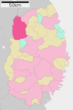 Location of Hachimantai in Iwate Prefecture | |||
 Hachimantai | |||
| Coordinates: 39°57′22″N 141°4′16″E / 39.95611°N 141.07111°ECoordinates: 39°57′22″N 141°4′16″E / 39.95611°N 141.07111°E | |||
| Country | Japan | ||
| Region | Tōhoku | ||
| Prefecture | Iwate | ||
| Area | |||
| • Total | 826.30 km2 (319.04 sq mi) | ||
| Population (February 28, 2017) | |||
| • Total | 26,579 | ||
| • Density | 30/km2 (80/sq mi) | ||
| Time zone | UTC+9 (Japan Standard Time) | ||
| City symbols | |||
| • Tree | Japanese red pine | ||
| • Flower | Rindo | ||
| • Bird | Copper pheasant | ||
| Phone number | 0195-76-2111 | ||
| Address | 62 Ōfuke dai-35 jiwari, Hachimantai-shi, Iwate-ken 028-7192 | ||
| Website | http://www.city.hachimantai.lg.jp/ | ||


Hachimantai (八幡平市 Hachimantai-shi) is a city located in Iwate Prefecture, Japan. As of 28 February 2017, the city had an estimated population of 26,579, and a population density of 32 persons per km2 in 10,490 households.[1] The total area of the city is 826.30 square kilometres (319.04 sq mi).
Geography
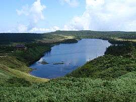
Hachimantai is located in the Ōu Mountains of far northwest Iwate Prefecture, bordered by Aomori Prefecture to the north and Akita Prefecture to the west. The headwaters of the Yoneshiro River are in Hachimanai. Part of Mount Hachimantai and Mount Iwate are within its borders. Parts of the city are within the borders of the Towada-Hachimantai National Park. Mount Iwate, the highest mountain in Iwate Prefecture, is on the border of Hachimantai with Shizukuishi and Takizawa.
Neighboring municipalities
Climate
Hachimantai has a humid continental climate (Köppen climate classification Dfa), the same as much of Hokkaido to the north, characterized by mild summers and cold winters with heavy snowfall. The average annual temperature in Hachimantai is 9.3 °C. The average annual rainfall is 1387 mm with September as the wettest month and February as the driest month. The temperatures are highest on average in August, at around 22.9 °C, and lowest in January, at around -3.4 °C.[2]
| Climate data for Hachimantai (former Matsuo Village、1981-2010) | |||||||||||||
|---|---|---|---|---|---|---|---|---|---|---|---|---|---|
| Month | Jan | Feb | Mar | Apr | May | Jun | Jul | Aug | Sep | Oct | Nov | Dec | Year |
| Record high °C (°F) | 12.4 (54.3) |
12.0 (53.6) |
18.0 (64.4) |
27.7 (81.9) |
31.8 (89.2) |
33.5 (92.3) |
35.2 (95.4) |
35.5 (95.9) |
34.0 (93.2) |
26.5 (79.7) |
20.7 (69.3) |
16.9 (62.4) |
35.5 (95.9) |
| Average high °C (°F) | 0.6 (33.1) |
1.6 (34.9) |
5.7 (42.3) |
13.7 (56.7) |
19.3 (66.7) |
23.3 (73.9) |
26.2 (79.2) |
27.8 (82) |
22.9 (73.2) |
16.9 (62.4) |
9.7 (49.5) |
3.6 (38.5) |
14.2 (57.6) |
| Daily mean °C (°F) | −3.4 (25.9) |
−2.8 (27) |
0.9 (33.6) |
7.6 (45.7) |
13.3 (55.9) |
17.6 (63.7) |
21.1 (70) |
22.4 (72.3) |
17.5 (63.5) |
10.9 (51.6) |
4.7 (40.5) |
−0.3 (31.5) |
9.1 (48.4) |
| Average low °C (°F) | −8.4 (16.9) |
−8.0 (17.6) |
−4.2 (24.4) |
1.3 (34.3) |
7.2 (45) |
12.6 (54.7) |
16.9 (62.4) |
18.1 (64.6) |
12.7 (54.9) |
5.2 (41.4) |
−0.2 (31.6) |
−4.5 (23.9) |
4.0 (39.2) |
| Record low °C (°F) | −21.8 (−7.2) |
−22.2 (−8) |
−15.4 (4.3) |
−11.0 (12.2) |
−2.7 (27.1) |
1.7 (35.1) |
7.7 (45.9) |
7.7 (45.9) |
1.3 (34.3) |
−4.3 (24.3) |
−11.0 (12.2) |
−18.0 (−0.4) |
−22.2 (−8) |
| Source: Japan Meteorological Agency[3] | |||||||||||||
Demographics
Per Japanese census data,[4] the population of Hachimantai has declined steadily over the past 40 years.
| Census Year | Population |
|---|---|
| 1970 | 36,764 |
| 1980 | 34,926 |
| 1990 | 33,287 |
| 2000 | 32,485 |
| 2010 | 28,690 |
History
The area of present-day Hachimantai was part of ancient Mutsu Province. The area was dominated by the Nanbu clan from the early Muromachi period. During the Edo period Tokugawa shogunate, the area was under Morioka Domain, and was divided between Ninohe District in the north and Iwate District in the south.
In the early Meiji period, the village of Arasawa was created within Ninohe District on April 1, 1889, with the establishment of the modern municipalities system. Arasawa merged with neighboring Tayama Village on September 30, 1956 to form the town of Ashiro. Ashiro was transferred to Iwate District on April 1, 2002.
Likewise, on April 1, 1889, the villages of Tairadate, Obun, Dendo and Terada were established within Kita-Iwate District. Kita-Iwate was merged with Minami-Iwate in 1896. The four villages merged on September 30, 1956 for form the town of Nishine.
The modern city of Hachimantai was established on September 1, 2005, from the merger of the towns of Ashiro and Nishine, and the village of Matsuo.
Government
Hachimantai has a mayor-council form of government with a directly elected mayor and a unicameral city legislature of 22 members.
Economy
The local economy is based on agriculture, forestry and seasonal tourism.
Education
Hachimantai has ten public elementary schools and four middle schools operated by the city government, and one public high school operated by the Iwate Prefectural Board of Education.
Transportation
Railway
- East Japan Railway Company (JR East) – Hanawa Line
- Higashi-Ōbuke - Ōbuke - Tairadate - Kitamori - Matsuo-Hachimantai - Appi-Kōgen - Akasakata - Koyanohata - Arayashimmachi - Yokoma - Tayama - Anihata
Highway
- Tōhoku Expressway – Nishine IC, Iwatesan SA, Matsuo-Hachimantai IC, Maemoriyama PA, Ajiro JCT, Ajiro IC, Tayama PA
- Hachinohe Expressway – Ajiro JCT
- Japan National Route 282 – Nishine roadside station
Sister cities


Local attractions
- Towada-Hachimantai National Park
- Mount Hachimantai
- Yakehashiri Lava Flow[5]
- Appi Kogen Ski Resort[6]
- Fudō Falls, One of Japan's Top 100 Waterfalls[7]
- Matsuo mine, an abandoned mine
- Matsukawa Gorge [8]
- Matsukawa Geothermal Power Plant, the first commercial geothermal plant in Japan
- Nanbu Fuji Golf Course [9]
- Hachimantai hot spring resorts [10]
Notable people from Hachimantai
- Hideji Oda – manga artist
- Hanahikari Setsuo – sumo wrestler
References
- ↑ Hachimantai city official statistics
- ↑ Hachimantai climate data
- ↑ "岩手松尾(八幡平) 19801-2010年". Japan Meteorological Agency. Retrieved 2011-10-18.
- ↑ Hachimantai population statistics
- ↑ "Yakehashiri Lava Flow ( Hachimantai City )". A Trip to Iwate. Iwate Prefecture Tourism Portal. Retrieved 28 March 2017.
- ↑ "Hachimantai Resort ( Panorama Ski Area/Shimokura Ski Area ) ( Hachimantai City )". A Trip to Iwate. Iwate Prefecture Tourism Portal. Retrieved 28 March 2017.
- ↑ "Fudo no Taki Falls ( Hachimantai City )". A Trip to Iwate. Iwate Prefecture Tourism Portal. Retrieved 28 March 2017.
- ↑ "Matsukawa Gorge ( Hachimantai City )". A Trip to Iwate. Iwate Prefecture Tourism Portal. Retrieved 28 March 2017.
- ↑ "Nambu Fuji Country Club ( Hachimantai City )". A Trip to Iwate. Iwate Prefecture Tourism Portal. Retrieved 28 March 2017.
- ↑ "Hachimantai Hot Springs and Appi Hot Springs ( Hachimantai City )". A Trip to Iwate. Iwate Prefecture Tourism Portal. Retrieved 28 March 2017.
External links
![]()
- Official Website (in Japanese)