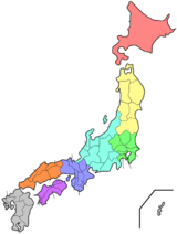
Hiroshima Prefecture
| Hiroshima Prefecture 広島県 | |||
|---|---|---|---|
| Prefecture | |||
| Japanese transcription(s) | |||
| • Japanese | 広島県 | ||
| • Rōmaji | Hiroshima-ken | ||
| |||
|
| |||
| Country | Japan | ||
| Region | Chūgoku (San'yō) | ||
| Island | Honshu | ||
| Capital | Hiroshima | ||
| Government | |||
| • Governor | Hidehiko Yuzaki (since November 2009) | ||
| Area | |||
| • Total | 8,476.95 km2 (3,272.97 sq mi) | ||
| Area rank | 11th | ||
| Population (March 1, 2011) | |||
| • Total | 2,857,990 | ||
| • Rank | 12th | ||
| • Density | 337.15/km2 (873.2/sq mi) | ||
| ISO 3166 code | JP-34 | ||
| Districts | 5 | ||
| Municipalities | 23 | ||
| Tree | Japanese maple (Acer palmatum) | ||
| Bird | Red-throated diver (Gavia stellata) | ||
| Website | pref.hiroshima.lg.jp | ||
Hiroshima Prefecture (広島県 Hiroshima-ken) is a prefecture of Japan located in the Chūgoku region on Honshu island.[1] The capital is the city of Hiroshima.[2] It has a population of around 2.8 million.
History
The area around Hiroshima was formerly divided into Bingo Province and Aki Province.[3] This location has been a center of trade and culture since the beginning of Japan's recorded history. Hiroshima is a traditional center of the Chūgoku region and was the seat of the Mōri clan until the Battle of Sekigahara.
Hiroshima is home to two UNESCO World Heritage sites:
- The Atomic Dome in Hiroshima, one of the few remnants of prewar Hiroshima following the atomic bombing in 1945;
- The Itsukushima Shrine in Miyajima, famed for filling with water and appearing to "float" during high tide.
Geography
Hiroshima prefecture lies in the middle of Japan . Most of the prefecture consists of mountains leading towards Shimane Prefecture; and rivers produce rich plains near the coast.
The province faces Shikoku across the Seto Inland Sea. Hiroshima Bay opens on the Inland Sea.[4] The prefecture also includes many small islands.
The sheltered nature of the Inland Sea makes Hiroshima's climate very mild.
As of 1 April 2014, 4% of the total land area of the prefecture was designated as Natural Parks (the lowest percentage of any prefecture), namely Setonaikai National Park; Hiba-Dōgo-Taishaku and Nishi-Chūgoku Sanchi Quasi-National Parks; and six Prefectural Natural Parks.[5]
Cities
Government Ordinance Designated City City Town
Fourteen cities are located in Hiroshima Prefecture:
Towns and villages
These are the towns in each district:
Mergers
Economy
Hiroshima's main industries include automobiles (Mazda is headquartered there) and tourism in two World Heritage sites: the A-Bomb dome and Itsukushima Shrine.
Components of the economy are primary industry, secondary industry, and tertiary industry, which compose 0.6%, 32.6%, and 66.2% in 2015. There is 0.6% of unclassified production.[6]
Value of production of manufacturing is 10,343 billion yen in 2016, which is the 10th largest in Japan. After 2012, production of manufacturing is continuously increasing in 2015.[7]
Education
University
- Hiroshima University
- Hiroshima Shudo University
- Prefectural University of Hiroshima
- Hiroshima University of Economics
- Hiroshima International University
- Hiroshima Bunka Gakuen University
- Hiroshima Bunkyo Women's University
- Hiroshima Cosmopolitan University
- Hiroshima Institute of Technology
- Hiroshima Kokusai Gakuin University
- Hiroshima City University
- Hiroshima Jogakuin University
- Hijiyama University
- Elisabeth University of Music
- Fukuyama University
- Fukuyama City University
- Fukuyama Heisei University
- Yasuda Women's University
- Onomichi City University
- Japan Coast Guard Academy
Transportation
Railway
People movers
Streetcars
Roads
Expressways
- Chugoku Expressway
- Sanyo Expressway
- Shimanami Expressway
- Hamada Expressway
- Onomichi Expressway
- Hiroshima Expressway (West Nippon Expressway Company)
- Hiroshima Expressway (urban expressway)
National highways
Ports
Airports
Sports
The sports teams listed below are based in Hiroshima.
Football
- Sanfrecce Hiroshima (Hiroshima city)
Baseball
- Hiroshima Toyo Carp (Hiroshima city)
Volleyball
- JT Thunders (Hiroshima city)
Basketball
- Hiroshima Dragonflies
- Hiroshima Lightning (Defunct)
Tourism
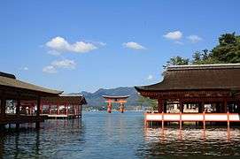 Itsukushima Shrine and Torii Gate (Hatsukaichi)
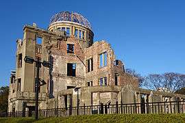 Hiroshima Peace Memorial (Hiroshima City)
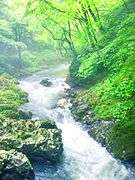 Taishaku Valley (Shobara)
 Road of longing (Shokei no michi) in Takehara on October
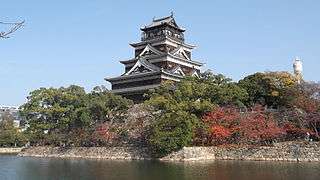 Hiroshima Castle
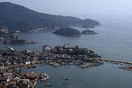 Tomonoura (Fukuyama)
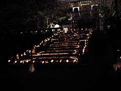
Famous festivals and events
- Onomichi Port Festival - held in April
- Hiroshima Flower Festival - held from May 3 to 5
- Fukuyama Rose Festival - held in May
- Enryuji Tokasan Festival - held in June
- Gion Festival of Onomichi - held in July
- Innoshima Water-naval Festival - held in August
- Miyajima Under-water Firework Festival - held on August 14
- Yassa Festival of Mihara - held in August
- Saijo Sake Festival - held in October
- Onomichi Becher Festival - held on November 3
- Hiroshima Ebisu Festival - held from November 18 to 20
Notes
- ↑ Nussbaum, Louis-Frédéric. (2005). "Hiroshima-ken" in Japan Encyclopedia, p. 320 at Google Books; "Chūgoku" at p. 127 at Google Books.
- ↑ Nussbaum, "Hiroshima" at pp. 319–20 at Google Books.
- ↑ Nussbaum, "Province and prefecture" at p. 780 at Google Books.
- ↑ Nussbaum, "Hiroshima Wan" at p. 320 at Google Books.
- ↑ "General overview of area figures for Natural Parks by prefecture" (PDF). Ministry of the Environment. 1 April 2014. Retrieved 22 February 2015.
- ↑ "平成27年度広島県民経済計算結果について" (PDF). 広島県.
- ↑ "平成 28 年経済センサス" (PDF). 広島県.
References
- Nussbaum, Louis-Frédéric and Käthe Roth. (2005). Japan encyclopedia. Cambridge: Harvard University Press. ISBN 978-0-674-01753-5; OCLC 58053128
External links
| Wikimedia Commons has media related to Hiroshima Prefecture. |
- Official Hiroshima Prefecture homepage
- Life in Hiroshima and other Japan-related Articles
- Hiroshima Weather Forecast
- National Archives of Japan ... Hiroshima map (1891)
- National Archives of Japan: Itsukushima kakei, illustrated scroll describing Itsukushima, text by Kaibara Ekiken (circa 1720)
- hiroshima-navi
| Wards of Hiroshima | |
|---|---|
| Core cities | |
| Cities | |
| Districts | |
Coordinates: 34°26′N 132°45′E / 34.433°N 132.750°E
| Authority control |
|---|