Storskrymten
| Storskrymten | |
|---|---|
 Storskrymten Location of the mountain  Storskrymten Storskrymten (Oppland)  Storskrymten Storskrymten (Møre og Romsdal)  Storskrymten Storskrymten (Norway) | |
| Highest point | |
| Elevation | 1,985 m (6,512 ft) |
| Prominence | 610 m (2,000 ft) |
| Listing | 5 at List of highest points of Norwegian counties |
| Coordinates | 62°22′21″N 9°03′42″E / 62.3725°N 09.0618°ECoordinates: 62°22′21″N 9°03′42″E / 62.3725°N 09.0618°E [1] |
| Geography | |
| Location |
Trøndelag, Oppdal, and Møre og Romsdal, Norway |
| Parent range | Dovrefjell |
| Topo map | 1419 I Storskrymten |
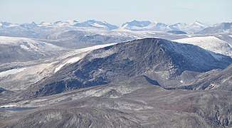
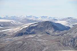
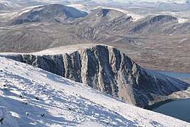
Storskrymten is a 1,985-metre (6,512 ft) tall mountain in Norway. The top of the mountain is a tripoint for three counties and three municipalities: Oppdal Municipality (Trøndelag county), Sunndal Municipality (Møre og Romsdal county), and Lesja Municipality (Oppland county). The nearest urban areas are the village of Sunndalsøra which is located about 42 kilometres (26 mi) to the northwest, Dombås which is located about 32 kilometres (20 mi) to the south, and Oppdal which is about 40 kilometres (25 mi) to the northeast.[2]
It is the highest mountain in all of Trøndelag county as well as the highest mountain in Sunndal municipality. Less than 2 kilometres (1.2 mi) east of Storskrymten is the mountain Litlskrymten which means "the little Skrymt". It is located in the Dovrefjell mountains and it is inside the Dovrefjell–Sunndalsfjella National Park.[2]
Name
The first element is stor which means "big" and the last element is the finite form of skrymt which means "uncanny thing", "fright", or "scare" (the hillsides of the mountain are extremely steep).
References
- ↑ "Storskrymten, Oppdal (Trøndelag)" (in Norwegian). yr.no. Retrieved 2018-01-23.
- 1 2 Thorsnæs, Geir, ed. (2015-11-30). "Storskrymten". Store norske leksikon (in Norwegian). Kunnskapsforlaget. Retrieved 2018-01-23.