Øksendalsøra
| Øksendalsøra | |
|---|---|
| Village | |
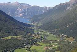 View of the village along the water | |
 Øksendalsøra Location in Møre og Romsdal  Øksendalsøra Øksendalsøra (Norway) | |
| Coordinates: 62°43′05″N 08°25′51″E / 62.71806°N 8.43083°ECoordinates: 62°43′05″N 08°25′51″E / 62.71806°N 8.43083°E | |
| Country | Norway |
| Region | Western Norway |
| County | Møre og Romsdal |
| District | Nordmøre |
| Municipality | Sunndal Municipality |
| Elevation[1] | 7 m (23 ft) |
| Time zone | UTC+01:00 (CET) |
| • Summer (DST) | UTC+02:00 (CEST) |
| Post Code | 6610 Øksendalsøra |
Øksendalsøra is a village in Sunndal Municipality in Møre og Romsdal county, Norway. The village is located along the Sunndalsfjorden at the northern end of the Øksendalen valley. The village sits about 10 kilometres (6.2 mi) northwest of the municipal centre of Sunndalsøra. The 6-kilometre (3.7 mi) long Øksendal Tunnel connects this village to the rest of Sunndal Municipality.
Øksendalsøra was the administrative centre of the old Øksendal Municipality that existed from 1854 until 1960. Øksendal Church is located in the village and it is the church for the Øksendal parish, covering the northwestern part of Sunndal Municipality.
Other villages in Sunndal Municipality
Gjøra, Grøa, Hoelsand, Jordalsgrenda, Romfo, Ålvund, Ålvundeidet, and Øksendalsøra
References
- ↑ "Øksendalsøra" (in Norwegian). yr.no. Retrieved 2013-04-24.
This article is issued from
Wikipedia.
The text is licensed under Creative Commons - Attribution - Sharealike.
Additional terms may apply for the media files.