Palasa
| Palasa | |
|---|---|
| town | |
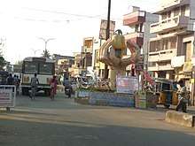
 Palasa Main Road | |
| Nickname(s): White Gold City | |
 Palasa Location in Andhra Pradesh, India | |
| Coordinates: 18°46′23″N 84°24′28″E / 18.773095°N 84.407830°ECoordinates: 18°46′23″N 84°24′28″E / 18.773095°N 84.407830°E | |
| Country | India |
| State | Andhra Pradesh |
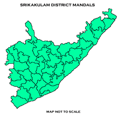
| District | Srikakulam |
| Government | |
| • Type | Democratic |
| Area[1] | |
| • Total | 42.75 km2 (16.51 sq mi) |
| Elevation | 38 m (125 ft) |
| Population (2011)[2] | |
| • Total | 57,507 |
| • Density | 1,300/km2 (3,500/sq mi) |
| Languages | |
| • Official | Telugu |
| Time zone | UTC+5:30 (IST) |
| PIN | 532221/22 |
| Telephone code | 08945 |
| Vehicle registration | AP–30 |
| Website | Palasa–Kasibugga Municipality |
Palasa is a town in Srikakulam district of the Indian state of Andhra Pradesh. It is a municipality and the mandal headquarters of Palasa mandal.[3] It is located near to the National Highway 5 between Srikakulam and Berhampur. Along with its twin town kasibugga[4], it is often referred to as Palasa-Kasibugga.

Geography
Palasa is located at 18.46N 84.25E. It has an average elevation of 38 meters (127 feet).[5] The town has an area of 42.75 km2 (16.51 sq mi).[1]
Demographics
As of 2011 census of India, Palasa had a population of 57,507 with 14,195 households. The total population constitute, 28,131 males and 29,376 females —a sex ratio of 1044 females per 1000 males. 5,609 children are in the age group of 0–6 years, of which 2,887 are boys and 2,722 are girls —a ratio of 943 girls per 1000 boys. The average literacy rate stands at 75.68% with 39,276 literates, significantly higher than the state average of 67.41%.[2][6]
Economy
There are more than 350 cashew processing industries around Palasa, the highest amongst the northern coastal districts. These twin cities are the largest cashew producing towns of Andhra Pradesh and are among the largest processing centres in India. The cashew industry provides direct and indirect employment to about 15,000 people in the surrounding areas.[7][8]
Healthcare
The Community Health Centre, Andhra Pradesh Vaidya Vidhana Parishad is located here. It can hold 50 inpatients.[9]
Transport
Roadways
National Highway 16, a part of Golden Quadrilateral highway network, bypasses the town.[10] A flyover was constructed in 2016 for the convenience of people across railway track.
Railways
Palasa railway station is Located in Andhra Pradesh, Srikakulam, Palasa. It is classified as an A–category station in the Khurda Road Railway Division under East Coast Railway.
Airport
The nearest airport is Visakhapatnam Airport which is approx. 200 km away.
Landmarks
Ratty, Akkupally, Metturu & Thoturu (Hanuman Saagar) beaches are nearly 14 km from Palasa railway station.
Government and politics
Palasa is classified as a 3rd Grade Municipality.Palasa (Assembly constituency) in Andhra Pradesh Legislative Assembly.in Palasa (Assembly constituency) Palasa, Mandasa and Vajrapu Kotturu mandals comes under this jurisdiction.
Education
The primary and secondary school education is imparted by government, aided and private schools, under the School Education Department of the state.[11][12] The medium of instruction followed by different schools are English, Telugu.
References
- 1 2 "Basic Information of Municipality". Commissioner & Director of Municipal Administration. Municipal Administration & Urban Development Department, Govt. of Andhra Pradesh. Retrieved 23 August 2014.
- 1 2 "Census of India Search details". censusindia.gov.in. Retrieved 10 May 2015.
- ↑ "Srikakulam district mandals" (PDF). Census of India. The Registrar General & Census Commissioner, India. pp. 175, 209. Retrieved 18 May 2015.
- ↑ "Leaders out to woo voters". 28 November 2007 – via www.thehindu.com.
- ↑ "Maps, Weather, and Airports for Palasa, India".
- ↑ "Literacy of AP (Census 2011)" (PDF). Official Portal of Andhra Pradesh Government. p. 43. Retrieved 5 September 2014.
- ↑ "APEDA blueprint to improve cashew production".
- ↑ "palasa kasibugga - Commissioner & Director of Municipal Administration". cdma.ap.gov.in.
- ↑ "APVVP.Hospitals" (PDF).
- ↑ "National Highways Development Project Map". National Highways Authority of India. Archived from the original on 22 April 2017. Retrieved 21 April 2017.
- ↑ "School Education Department" (PDF). School Education Department, Government of Andhra Pradesh. Archived from the original (PDF) on 27 December 2015. Retrieved 7 November 2016.
- ↑ "The Department of School Education - Official AP State Government Portal | AP State Portal". www.ap.gov.in. Archived from the original on 7 November 2016. Retrieved 7 November 2016.
External links
| Wikimedia Commons has media related to Palasa. |