Ponnaiyar River
| தென்பெண்ணை(பொன்னையார்) ದಕ್ಷಿಣ ಪಿನಾಕಿನಿ (ಪೊನ್ನೈಯಾರು) South Pennar Thenpennai Pennaiyar Ponnaiyar | |
|---|---|
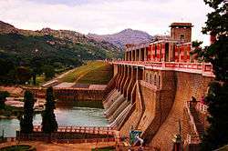 Krishnagiri Dam across the river | |
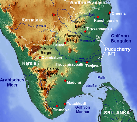 Map of the South Pennar river flowing through Karnataka and Tamil Nadu | |
| Country | India |
| States | Karnataka and Tamil Nadu |
| Cities |
Kolar, Hoskote, Kadugodi, Whitefield, Bagalur, Hosur, Krishnagiri, Chengam, Thanipaddy, Tiruvannamalai, Manalurpet, Tirukkovilur, Cuddalore |
| Physical characteristics | |
| Main source |
Nandi Hills Chikkaballapura, Karnataka 1,276 m (4,186 ft) |
| River mouth |
Bay of Bengal Cuddalore, Tamil Nadu 0 m (0 ft) 11°21′40″N 79°19′46″E / 11.36111°N 79.32944°ECoordinates: 11°21′40″N 79°19′46″E / 11.36111°N 79.32944°E |
| Length | 500 km (310 mi) |
| Basin features | |
| Tributaries |
|
The South Pennar River is known as Dakshina Pinakini in Kannada and Thenpennai or Ponnaiyar in Tamil.
The river originates in the Nandi Hills in the Chikkaballapura district of Karnataka and flows through Tamil Nadu before emptying into the Bay of Bengal. It has a catchment area of 1,424 square miles (3,690 km2) located in Karnataka, Tamil Nadu and Andhra Pradesh states. Small dams of Kelavarapalli and Krishnagiri dams are built across this river near Hosur and Krishnagiri.[1]The largest dam on this river , Sathanur Dam with 7.3 Tmcft Gross Capacity is built near Tiruvannamalai. Moongilthuraipattu Sugar Factory is also situated on the bank of river.
The river is dry for the most part of the year. Water flows during the monsoon season when it is fed by the south-west monsoon in catchment area and the northeast monsoon in Tamil Nadu. However this water flow raises the water table throughout the river basin and feeds numerous reservoirs/tanks.
The old river Dakshina Pinakini does not exist anymore.[2] Substantial part of Bangalore's sewage enters this river via Bellandur and Varthur Lakes and other channels.[3]
The sand build of the river is quite impressive, suggesting that it may have been a perennial river with much larger water flow in the past. Mention of the river is found in Sangam and medieval (Thevaram - Bhakti cult era) literature, where it is depicted as rich with lush vegetation on its banks. There are various temples on its banks. It irrigates Krishnagiri, Tiruvannamalai, Vizhuppuram and Cuddalore districts and empties into the Bay of Bengal
This river is now looted for its rich availability of sand. As the water flow will be only in monsoon seasons, the river is dry in remaining parts of the year.
Sand mafia is biggest and most dangerous elements behind killing of large rivers in south India.
See also
References
- ↑ Kelavarapalli dam
- ↑ P M Raghunandan (April 23, 2012). "TN now lays claim to City sewage". Bangalore: Deccan Herald. Retrieved 19 August 2016.
- ↑ S. Prasad. "Water from Krishnagiri dam raises a scare". The Hindu. Retrieved 19 August 2016.