Kneževo, Bosnia and Herzegovina
| Kneževo Кнежево | ||
|---|---|---|
| Town and municipality | ||
| ||
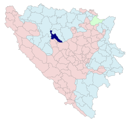 Location within Bosnia and Herzegovina | ||
| Coordinates: 44°28′16″N 17°22′44″E / 44.47111°N 17.37889°ECoordinates: 44°28′16″N 17°22′44″E / 44.47111°N 17.37889°E | ||
| Country | Bosnia and Herzegovina | |
| Entity | Republika Srpska | |
| Government | ||
| • Mayor | Bore Škeljić (SDS) | |
| Area | ||
| • Total | 332.9 km2 (128.5 sq mi) | |
| Population (2013 census) | ||
| • Total | 9,793 | |
| • Density | 29/km2 (76/sq mi) | |
| Time zone | UTC+1 (CET) | |
| • Summer (DST) | UTC+2 (CEST) | |
| Area code(s) | 51 | |
| Website | Official Kneževo Municipality Website | |
.svg.png)
Kneževo (Serbian Cyrillic: Кнежево; formerly known as Skender Vakuf / Скендер Вакуф) is a town and municipality located in northwestern Republika Srpska, an entity of Bosnia and Herzegovina. As of 2013, it has a population of 9,793 inhabitants.
Name
Up until the 1992-1995 Bosnian War, the town was known as Skender Vakuf. During the war the town was renamed Kneževo by the Serb authorities.[1] Accordingly, many media outlets continue to refer to the area as Skender Vakuf-Kneževo.[2]
Geography
Kneževo is located between the rivers Ugar, Vrbas and Vrbanja and surrounded by the mountain chains of Čemernica, Ranča in the west, Vlašić in the south and Ježica in the north-east. The municipality has an official altitude of 864 metres (2,835 ft), but really ranges from 600 to 1,493 metres (1,969 to 4,898 ft). Kneževo is 50 kilometres (31 mi) southeast of Banja Luka by the M56 motorway.
Neighbouring municipalities are Čelinac (extreme north), Kotor Varoš (east), Travnik, Dobretići, Jajce (south), Mrkonjić Grad and the city of Banja Luka (west). The southern border is defined by the border of the Republika Srpska with the Federation of Bosnia and Herzegovina, the country's other entity. The mountainous region in the south is forested and impracticable; its limestone mountains reach a height of 1,493 metres (4,898 ft).[3][4][5][6]
History
Roman basilica have been found in Imljani and Javorani, and remains of the Roman road from Servitium (Banja Luka) to Levsaba (Travnik) were also found in the vicinity. Tombstones of the Stećak type date back to the 14th and 15th centuries, when the area was part of the Kingdom of Bosnia. The town was founded in the Ottoman Empire. It is first mentioned in the records of a Muslim judge from Jajce in 1693, while there is no record of it in the census of the Bosnia Eyalet of 1604. Two generations of imams are mentioned in the records, which means it was most likely founded in the latter half of the 17th century. The architecture of the Old Mosque in Skender-Vakuf also indicates it was built in the latter half of the 17th century. The charitable endowment (vakuf) that is reflected in the town's traditional name Skender Vakuf (after Ali-dedo Skender) contributed to urbanization.[7] The Old Mosque was significant and one of the first in the region. It was destroyed, along with the New Mosque, in 1992 during the Bosnian War.
In the Korićani Cliffs massacre of 21 August 1992, some 200 Bosniaks and Croats detainees were massacred by the Bosnian Serbs Police and Army forces from Prijedor (in deep cliff in the canyon of Ilomska) river.
After the Bosnian War, part of the municipality was split off to form the Dobretići municipality of the Federation of Bosnia and Herzegovina entity.
Settlements
Aside from the town of Kneževo, the municipality includes the following settlements:
- Bastaji
- Bekići
- Bokani
- Borak
- Bregovi
- Vlatkovići
- Golo Brdo
- Gornji Korićani
- Doline
- Donji Korićani
- Živinice
- Imljani
- Javorani
- Kobilja
- Korićani
- Kostići
- Milovići
- Mokri Lug
- Pavlovići
- Paunovići
- Petrovo Polje
- Ravni Sto
- Rađići
- Ćeleši
- Ćukovac
- Čarići
- Šolaji
Demographics
| Historical population | ||
|---|---|---|
| Year | Pop. | ±% p.a. |
| 1961 | 9,190 | — |
| 1971 | 21,419 | +8.83% |
| 1981 | 22,948 | +0.69% |
| 1991 | 19,418 | −1.66% |
| 2013 | 9,793 | −3.06% |
According to the preliminary results of the 2013 population census in Bosnia and Herzegovina, there were 3,958 inhabitants in Knezevo town, and 10,428 inhabitants in the Knezevo municipality.[8]
Ethnic groups
- Municipality
| Ethnic Composition | |||||||||||||
| Year | Serbs | % | Croats | % | Bosniaks | % | Yugoslavs | % | Others | % | Total | ||
|---|---|---|---|---|---|---|---|---|---|---|---|---|---|
| 1961 | 8,564 | 93.12% | 19 | 0.21% | 560 | 6.09% | 28 | 0.89% | 19 | 0.21% | 9,190 | ||
| 1971 | 15,926 | 74.35% | 4,431 | 20.69% | 947 | 4.42% | 9 | 0.04% | 106 | 0.49% | 21,419 | ||
| 1981 | 15,953 | 69.52% | 5,395 | 23.51% | 1,141 | 4.97% | 322 | 1.40% | 141 | 0.61% | 22,948 | ||
| 1991 | 13,263 | 68.30% | 4,770 | 24.56% | 1,071 | 5.52% | 169 | 0.87% | 145 | 0.75% | 19,418 | ||
| 2013 | 9,288 | 94.84% | 429 | 4.38% | 31 | 0.31% | 0.00 | 0.00% | 37 | 0.37% | 9,793 | ||
| Note:After 1961 the municipal borders changed. The municipality became significantly larger. | |||||||||||||
After the war, the majority of the old Skender Vakuf municipality became part of the new Kneževo municipality of the Republika Srpska entity. Four Croatian pre-war settlements became part of the new Dobretići municipality of the Federation of Bosnia and Herzegovina entity.
- Town
| Ethnic Composition | |||||||||||||
| Year | Serbs | % | Croats | % | Muslims/Bosniaks | % | Yugoslavs | % | Others | % | Total | ||
|---|---|---|---|---|---|---|---|---|---|---|---|---|---|
| 1961 | 383 | 38.61% | 16 | 1.61% | 560 | 56.45% | 28 | 2.82% | 5 | 0.50% | 992 | ||
| 1971 | 723 | 42.83% | 17 | 1.01% | 923 | 54.68% | 5 | 0.30% | 20 | 1.18% | 1,688 | ||
| 1981 | 1,491 | 51.24% | 45 | 1.55% | 1,118 | 38.42% | 205 | 7.04% | 51 | 1.75% | 2,910 | ||
| 1991 | 2,484 | 66.08% | 42 | 1.12% | 1,063 | 28.28% | 111 | 2.95% | 59 | 1.57% | 3,759 | ||
Culture
The municipality houses several cultural monuments, such as the Old Church of St. Nicholas from 1757, the 18th-century Church of Prophet Elijah.
In Imljani there is a monument dedicated to 43 fallen soldiers of the Army of Republika Srpska who fell at the Vlašić battlefield on 20 March 1995.[9]
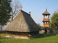 Wooden church in Javorani.
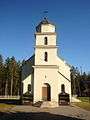 Serbian Orthodox church in Kneževo
.jpg) Kneževo municipality building
Kneževo municipality building
Politics
The mayor of Knezevo is Bore Škeljić, of the Serb Democratic Party (SDS).[10]
Notable people
- Radojka Lakić, National Hero of Yugoslavia
- Luka Radetić, National Hero of Yugoslavia
- Dujko Komljenović, National Hero of Yugoslavia
- Lazar Tešanović, Chetnik officer, born in Javorani
- Željko Raljić, journalist
- Momir Ćelić, professor
- Tihomir Radetić, film director
Annotations
According to the 1991 census, the municipality consisted of: Bastaji, Bokani, Borak, Bregovi, Brnjići, Bunar, Čarići, Ćukovac, Davidovići, Dobratići, Donji Orašac, Golo Brdo, Gornji Orašac, Imljani, Javorani, Kobilja, Kostići, Kričići - Jejići, Melina, Mijatovići, Milaševci, Mokri Lug, Paunovići, Pavlovići, Prisika, Rađići, Skender Vakuf, Slipčevići, Šolaji, Vitovlje Malo, Vlatkovići, Vukovići, Zapeće, Zasavica, Zubovići and Živinice.
In 1995, the municipality included Bastaji, Bokani, Borak, Bregovi, Čarići, Ćukovac, Golo Brdo, Imljani, Javorani, Kobilja, Kostići, Malići, Mokri Lug, Paunovići, Rađići, Kneževo, Šolaji, Vlatkovići and Živinice; the south-western settlements of Davidovići, Dobretići, Kričići and Melina became part of the municipality of Dobretići in the Federation of Bosnia and Herzegovina.
References
- ↑ https://books.google.com/books?id=7R9_DAAAQBAJ&pg=PA13&dq=Skender+Vakuf&hl=en&sa=X&ved=0ahUKEwjQveD4rKPOAhWB9x4KHRz8Ao4Q6AEIHjAA#v=onepage&q=Skender%20Vakuf&f=false
- ↑ http://www.novosti.rs/vesti/planeta.300.html:618063-MASOVNA-TUCA-Devetorica-se-potukla-zbog-bureka
- ↑ Vojnogeografski institut (1955). Vlašić (in Serbo-Croatian). Belgrade: Vojnogeografski institut.
- ↑ http://www.kartabih.com/
- ↑ Spahić M. et al. (2000): Bosna i Hercegovina (1:250.000). Izdavačko preduzeće „Sejtarija“, Sarajevo.
- ↑ Mučibabić B., ed. (1998). Geografski atlas Bosne i Hercegovine. Sarajevo: Geodetski zavod BiH. ISBN 9958-766-00-0.
- ↑ Language Evolution in Bosnia Archived 2012-06-16 at the Wayback Machine.
- ↑ "Попис становништва, домаћинстава и станова у Босни и Херцеговини 2013 на територији Републике Српске — Прелиминарни резултати" (PDF). Banja Luka: Републички завод за статистику. 2013. Archived from the original (PDF) on 2014-01-24.
- ↑ "ПАРАСТОС У ИМЉАНИМА". RTRS. 2012-03-20.
- ↑ "LOKALNI IZBORI 2012 - POTVRĐENI REZULTATI". Izbori.ba. 2012-11-06.
External links
| Wikimedia Commons has media related to Kneževo. |