Imljani
| Imljani | |
|---|---|
 | |
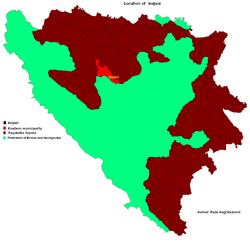 Location of Imljani in Bosnia and Herzegovina | |
| Coordinates: 44°24′02″N 17°29′29″E / 44.40056°N 17.49139°ECoordinates: 44°24′02″N 17°29′29″E / 44.40056°N 17.49139°E | |
| Country | Bosnia and Herzegovina |
| Entity | Republika Srpska |
| Municipality | Skender Vakuf/Kneževo |
| Population (1991) | |
| • Total | 1,565 |
| Time zone | UTC+2 (EET) |
| • Summer (DST) | UTC+3 (EEST) |
| Postal code | 78234 |
| Area code(s) | (+387) 51 |
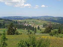
Imljani (Serbian Cyrillic: Имљани), is a village in Bosnia and Herzegovina, Entity of Republika Srpska, Skender Vakuf Municipality. Since 1954, Imljani was one of local communities of Former Šiprage Municipality in Former Kotor Varoš County.
Imljani consists of a few hamlets spreading on the Undervlašić's plateau, above the canyons of Ilomska and Ugar rivers. Actually, it covers the sub-plateau in the area of the angle between Korićanske stijene and Ugarske stijene ("Rocks of Ugar").[1][2][3][4][5][6]
Central hamlet the Vidovište is on (around) 1200 meters above sea level. Around Vidovište, from Kobilja river (south-west) to Ilomska's canyon (north-east) there are the hamlets, as follows - North-eastern: Rijeka, Potok, Ponorci, Osredok, Benići, Škeljići, Pušići, Marići, Đenići and Đekin Do; South-western: Vujinovići, Makarići, Kelemeni, Novakovići, Šodolovići and Borje.
- Traditional women costumes (front and back) in Imljani (Hamlet Grubači, ≈1810)
Ethnic composition, 1991 census
| Ethnic composition of Skender Vakuf municipality, by settlements, 1991. census | ||||||
| settlement | total | Serbs | Muslims | Croats | Yugoslavs | others |
| Imljani | 1,565 | 1,544 | 3 | 1 | 5 | 12 |
- Demography
| Imljani[7][8] | ||||||
| Census Year | 1991 | 1981 | 1971 | |||
| Serbs | 1,544 (98.65%) | 2,044 (98.83%) | 2,052 (99.37%) | |||
| Bosniaks | 3 (0.19%) | 1 (0.04%) | 0 | |||
| Croats | 1 (0.06%) | 6 (0.29%) | 5 (0.24%) | |||
| Yugoslavians | 5 (0.31%) | 2 (0.09%) | 0 | |||
| Others and unknown | 12 (0.76%) | 15 (0.72%) | 8 (0.38%) | |||
| Total | 1,565 | 2,068 | 2,065 | |||
See also
References
- ↑ http://www.kartabih.com/
- ↑ Vojnogeografski institut, Izd. (1955): Travnik (List karte 1:100.000, Izohipse na 20 m). Vojnogeografski institut, Beograd.
- ↑ Spahić M. et al. (2000): Bosna i Hercegovina (1:250.000). Izdavačko preduzeće „Sejtarija“, Sarajevo.
- ↑ Mučibabić B., ed. (1998). Geografski atlas Bosne i Hercegovine. Sarajevo: Geodetski zavod BiH. ISBN 9958-766-00-0.
- ↑
- ↑
- ↑ Book: "Nacionalni sastav stanovništva - Rezultati za Republiku po opštinama i naseljenim mjestima 1991.", statistički bilten br. 234, Izdanje Državnog zavoda za statistiku Republike Bosne i Hercegovine, Sarajevo.
- ↑ Internet - Source: "Popis po mjesnim zajednicama" - "Archived copy" (PDF). Archived from the original (PDF) on 2013-10-05. Retrieved 2013-02-11. .