Patnitop
| Patnitop | |
|---|---|
| Hill Station | |
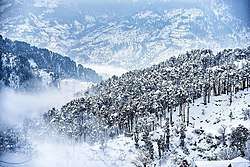 Patnitop in Winters | |
 Patnitop Location in Jammu and Kashmir  Patnitop Patnitop (India) | |
| Coordinates: 33°5′25″N 75°19′35″E / 33.09028°N 75.32639°E | |
| Country |
|
| State | Jammu and Kashmir |
| District | Udhampur |
| Elevation | 2,024 m (6,640 ft) |
| Time zone | UTC+5:30 (IST) |
| PIN | 182142 |
| Website |
patnitop |
Patnitop or Patni Top is a hilltop tourist location in Udhampur district in Jammu and Kashmir state of India on National Highway 44 112 km (70 mi) from Jammu on the way from Udhampur to Srinagar. Situated on a plateau in the Shivalik belt of the Himalayas, Patnitop sits at an altitude of 2,024 m (6,640 ft). The river Chenab flows in close proximity to this location.[1]
Patnitop bypass road tunnel
Snowfall and avalanche in winter at Patnitop obstructs National Highway 44 (earlier name: National Highway 1A) a few times every winter and causes long queues of vehicles - sometimes for days at length. India's longest road tunnel, the 9.2 km (6 mi) long Chenani-Nashri Tunnel or Patnitop Tunnel has been thrown open and starts from about 2 km (1 mi) from Chenani town south of Patnitop to Nashri village north of Patnitop reducing the distance from Jammu to Srinagar and traffic jams on NH 44 that occurred earlier due to snowfall and avalanche in winter at Patnitop.[2]
The Southern portal (end) of the tunnel is at 33°02′47″N 75°16′45″E / 33.0463°N 75.2793°E and the Northern portal (end) of the tunnel is at coordinates 33°07′43″N 75°17′34″E / 33.1285°N 75.2928°E. The Jammu- Srinagar highway no longer passes through Patnitop and this tunnel has reduced the length of the highway by 31 km (19 mi) and the highway has bypassed Patnitop.[3]
Gallery
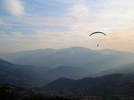 Paragliding at Patnitop
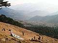 Dawariyai take off area at Patnitop
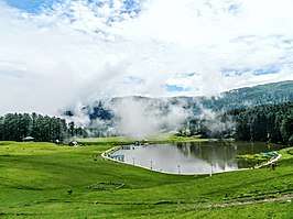 Sanasar Lake
References
- ↑ Silas, Sandeep (2005). "17. Patnitop". Discover India by Rail. Sterling Publishers. p. 47. ISBN 81-207-2939-0.
- ↑ "Chenani Nashri Tunnel Completes 2 km Excavation". ConstructionWeekOnline.in.
- ↑ http://economictimes.indiatimes.com/slideshows/infrastructure/chenani-nashri-indias-longest-road-tunnel-to-open-for-traffic-in-2016/four-lane-project/slideshow/48291517.cms