Hyder, Alaska
| Hyder, Alaska | |
|---|---|
| CDP | |
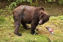
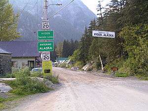 The border between Stewart, British Columbia and Hyder, as seen from the Canadian side. | |
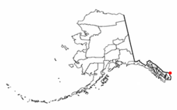 Location of Hyder, Alaska. | |
| Coordinates: 55°54′51″N 130°01′28″W / 55.91417°N 130.02444°WCoordinates: 55°54′51″N 130°01′28″W / 55.91417°N 130.02444°W | |
| Country | United States |
| State | Alaska |
| Census area | Prince of Wales-Hyder |
| Government | |
| • State senator | Bert Stedman (R) |
| • State rep. | Dan Ortiz (I) |
| Area | |
| • Total | 14.8 sq mi (38.4 km2) |
| • Land | 14.8 sq mi (38.4 km2) |
| • Water | 0.0 sq mi (0.0 km2) |
| Elevation | 118 ft (36 m) |
| Population (2010) | |
| • Total | 87 |
| • Density | 5.9/sq mi (2.3/km2) |
| Time zone |
Official time: Alaska (AKST)[1] Unofficial time: PST[2] |
| • Summer (DST) |
Official time: AKDT[1] Unofficial time: PDT[2] |
| ZIP Code | 99923 |
| Area code(s) | 236, 250, 778 |
| FIPS code | 02-34570 |
| GNIS feature ID | 1422711 |
Hyder is a census-designated place (CDP) in Prince of Wales-Hyder Census Area, Alaska, United States. The population was 87 at the 2010 census, down from 97 in 2000.[3] Hyder is accessible by road from British Columbia, and is popular with motorists wishing to visit Alaska without driving the length of the Alaska Highway. It is the southernmost community in the state that can be reached via car (others can only be reached by boat or plane). Hyder is Alaska's easternmost town.[4] There are no American border controls at the Hyder - Stewart Border Crossing.[5]
Geography
Hyder is located at 55°56′29″N 130°3′16″W / 55.94139°N 130.05444°W (55.941442, -130.054504),[6] at the head of the Portland Canal, a 130-mile (210 km) long fjord which forms a portion of the border between the U.S. and Canada at the southeastern edge of the Alaska Panhandle. It sits about 2 miles (3.2 km) from Stewart, British Columbia by road, and 75 miles (121 km) from Ketchikan by air.
According to the U.S. Census Bureau, the CDP has a total area of 14.8 square miles (38 km2), all land.
Demographics
| Historical population | |||
|---|---|---|---|
| Census | Pop. | %± | |
| 1920 | 237 | — | |
| 1930 | 254 | 7.2% | |
| 1940 | 72 | −71.7% | |
| 1950 | 30 | −58.3% | |
| 1960 | 32 | 6.7% | |
| 1970 | 49 | 53.1% | |
| 1980 | 77 | 57.1% | |
| 1990 | 99 | 28.6% | |
| 2000 | 97 | −2.0% | |
| 2010 | 87 | −10.3% | |
| U.S. Decennial Census[7] | |||
Hyder first appeared on the 1920 U.S. Census as an unincorporated village. It was made a census-designated place (CDP) in 1980.
As of the census[8] of 2000, there were 97 people, 47 households, and 25 families residing in the CDP. The population density was 6.5 people per square mile (2.5/km²). There were 72 housing units at an average density of 4.9 per square mile (1.9/km²). The racial makeup of the CDP was 93 White, and 4 from two or more races. There was 1 Hispanic or Latino of any race.
There were 47 households out of which 9 had children under the age of 18 living with them, 24 were married couples living together, 1 had a female householder with no husband present, and 21 were non-families. 19 of all households were made up of individuals and 3 had someone living alone who was 65 years of age or older. The average household size was 2.06 and the average family size was 2.81.
In the CDP, the population was spread out with 18 under 18, 11 from 18 to 24, 16 from 25 to 44, 45 from 45 to 64, and 7 who were 65 or older. The median age was 46 years. There were 44 females and 53 males, of them 34 females were age 18 and over, as were 45 males.
The median income for a household in the CDP was $11,719, and the median income for a family was $30,500. Males had a median income of $56,250 versus $13,750 for females. The per capita income for the CDP was $11,491. There were 44.4% of families and 54.1% of the population living below the poverty line, including 81.0% under 18, and 50.0% over 64.
Transportation
Stewart, British Columbia immediately borders Hyder and is accessible by road via International Street. Outside of the town site, NFD-88 heads in a northerly direction winding through the Tongass National Forest, and enters the outer extent of Stewart's municipal limits continuing as Granduc Road. There are few local roads, and no roads connect Hyder to any other Alaskan communities. The AMHS ferry that once connected Hyder to Ketchikan stopped running in the 1990s, leaving the Taquan Air floatplane that arrives twice a week with U.S. Mail at Hyder Seaplane Base as the only direct public transportation between Hyder and the rest of Alaska.[9][10]
Local services
There are few local services in town:
- US Postal Service
- US Forest Service Info Kiosk
- Camp Run-A-Muck
- Hyder Community Association – home to museum, information center, library
- This N That Shop
- Sealaska Inn
- Boundary Gift store
Public utilities
Hyder's public utilities are imported from Canada.[3] Electricity is maintained by a subsidiary of BC Hydro, the Tongass Power and Light Company as part of a long-term contract[11] with the town. While most of Alaska is in area code 907, Hyder shares the Stewart 749 exchange in area code 236, 636 in area code 250, and 794 in area code 778.[12] Telus operates the network allowing local calls from Hyder to be placed to Stewart, while the Alaska Telephone Company handles billing and customer service.
Public safety
Alaska State Troopers patrol the town, but are not located in town. There is a small volunteer EMS team in Hyder,[13] but there are no fire services in town. During an Independence Day fireworks display, the organizers accidentally burned down their fire hall with the fire engine inside.[14] When required, they are provided from across the border by nearby Stewart:
- British Columbia Ambulance Service – limited local service or from remote stations outside of Stewart
- District of Stewart Fire & Emergency Services Department – volunteer fire services
A Canada Border Services Agency customs post is located 100 yards from the town and used by all visitors and residents as it provides the only road connecting out of Hyder.
History
The Nisga'a, who lived around the Nass River, called the head of Portland Canal "Skam-A-Kounst," meaning safe place, probably because it served them as a retreat from the harassment of the Haidas on the coast.[15] They traveled in the area seasonally to pick berries and hunt birds.
The area around the Portland Canal was explored in 1896 by Captain D.D. Gaillard of the U.S. Army Corps of Engineers.[15]
In 1898, gold and silver lodes were discovered in the region, mainly on the Canadian side, in the upper Salmon River basin. The Stewart brothers, for whom the British Columbia town was named, arrived in 1902.
Hyder was established in 1907 as Portland City, after the canal.[4] In 1914, when the US Post Office Department told residents that there were many U.S. communities named Portland, it was renamed Hyder, after Frederick Hyder, a Canadian mining engineer who envisioned a bright future for the area. Hyder was the only practical point of access to the silver mines in Canada; the community became the port, supply point, and post office for miners by 1917. Hyder's boom years were the 1920s, when the Riverside Mine on the U.S. side extracted gold, silver, copper, lead, zinc, and tungsten. The mine operated from 1924 to 1950.
In 1928, the Hyder business district was consumed by fire.[15] By 1956 all significant mining had ceased, except for the Granduc Mine on the Canadian side, which operated until 1984 and 2010 to present.[16] Westmin Resources Ltd operated a gold and silver mine on the Canadian side in Premier, British Columbia but is not currently active.[17]
Culture
Hyder is accessible by highway from Stewart, which connects with the British Columbia highway system and claims 100,000 tourists annually.[18] It is the location of the annual Hyder Seek gathering of long-distance motorcyclists who travel from all over North America each Memorial Day weekend. It became popular with long distance motorcycle riders in 1998 when author Ron Ayres set a record of riding to the contiguous 48 states in six days. Ayres went on to add to the 48-state record by continuing on to Hyder to establish a new 49-state record of 7 days, 0 hours and 20 minutes. Ayres named the new long distance ride the "48 Plus" and it has become popular with members of the long-distance motorcycle riding Iron Butt Association.[19][20][21][22][23][24] Hyder was the starting point of the 2014 coast-to-coast Scooter Cannonball Run, which ended in New Orleans, Louisiana.[25]
Because of its accessible proximity to Stewart, and its isolation from other communities in Alaska, Hyder has many commonalities with its Canadian neighbor, with both American and Canadian holidays observed,[5] and a shared international Chamber of Commerce.[26] Children who live in Hyder attend the Bear Valley School in Stewart.[5] It is the only place in Alaska not to use the 907 area code, instead using British Columbia's 250.[5] Although Hyder is officially in the Alaska Time Zone, residents set their clocks to British Columbia's Pacific Time. Both American and Canadian currency are accepted,[5] except by the U.S. Post Office, which accepts only American dollars.
A local tradition is known as being "Hyderized", with two of the town's bars issuing certifications to patrons who consume a shot of 151 proof (75.5% alcohol) Everclear.[27][28]
See also
References
- 1 2 "Hyder, Alaska current local time and time zone". Retrieved February 5, 2012.
Hyder, Alaska is in the Alaska Time Zone
- 1 2 "Stewart, British Columbia current local time and time zone". Retrieved February 5, 2012.
Stewart, British Columbia is in the Pacific Time Zone
- 1 2 "Alaska Division of Community and Regional Affairs. Alaska Community Database Community Information Summaries (CIS). Hyder". State of Alaska. Archived from the original on December 24, 2012. Retrieved January 21, 2012.
During the Prohibition era, a small community called 'Hyder, BC' was created just across the Canadian border to serve as a legal speakeasy to the Hyder mining community, even housing its own Canadian Customs office.
- 1 2 Geological Survey Professional Paper. U.S. Government Printing Office. 1967. p. 440. Retrieved May 25, 2013.
...was established in 1907 and named "Portland City" because of its location. When the post office was established in 1915, the U.S. Post Office Dept. rejected this name.
- 1 2 3 4 5 "Folks living in this tiny outpost on the Alaskan border may use Canadian dollars, but they're still '100% American'". National Post. 2013-09-11. Retrieved 2017-08-12.
- ↑ "US Gazetteer files: 2010, 2000, and 1990". United States Census Bureau. February 12, 2011. Retrieved April 23, 2011.
- ↑ "U.S. Decennial Census". Census.gov. Retrieved June 6, 2013.
- ↑ "American FactFinder". United States Census Bureau. Archived from the original on September 11, 2013. Retrieved January 31, 2008.
- ↑
Paul Whitfield (April 26, 2004). Rough guide to Alaska. Rough Guides. p. 97. ISBN 978-1-84353-258-3. Retrieved January 16, 2012.
...it shares a Canadian phone code (250), time zone, Canadian currency (though greenbacks are also accepted), and Canadian national holidays.
- ↑ "Taquan Air's Inside Passage Flight Schedule: Summer 2011". Taquan Air. Archived from the original on July 16, 2011. Retrieved February 24, 2011.
- ↑ BC Hydro and Power Authority, 2015/16 – 2017/18 Service Plan http://www.bcbudget.gov.bc.ca/2015/sp/pdf/agency/bchydro.pdf
- ↑ Rate centre information for ILEC 8086 TELUS http://localcallingguide.com/lca_exch.php?exch=017550
- ↑ EMS team member in hyder
- ↑ Andrew Kleinfeld and Judith Kleinfeld (July 19, 2004). "Go Ahead, Call Us Cowboys". The Wall Street Journal. Retrieved June 16, 2016.
- 1 2 3 "Hyder". State of Alaska - Department of Commerce, Community, and Economic Development. Retrieved February 6, 2016.
- ↑ Ellsworth Dickson (August 2012). "Castle Resources plans to re-open Granduc Copper Mine" (PDF). Resource World Magazine. Archived from the original (PDF) on March 2, 2016. Retrieved February 23, 2016.
- ↑ BC Geological Survey (BCGS). "MINFILE Mineral Inventory No 104B 054". British Columbia Ministry of Energy and Mines and Responsible for Core Review. Retrieved February 23, 2016.
- ↑ Levin, Dan (July 2, 2016). "An Alaskan Village Where Grizzlies Roam and Canada Rules (if Anyone Does)". The New York Times. Retrieved July 5, 2016.
- ↑ John E. Van Barriger (June 1994), "Canadian Detours: the Long Road to Alaska", American Motorcyclist, 48 (6), ISSN 0277-9358
- ↑
Tim Yip (March–April 2008). "Edmonton to Alaska". Roadrunner.
Joining a band of motorcyclists on an annual run to Hyder, Alaska, we rode north from Edmonton to celebrate Ron Ayres's 1998 feat of smashing the Iron Butt record (riding to 48 states within 10 days) in what is now called the 48 Plus! Iron Butt Ride.
- ↑ "About Hyder Seek". Hyder Seek 2012 site. Paul Lawson.
- ↑ Lynn Anderson (March 2011), "Proving your worth, earning your chops", The Best Times, Johnson County Kansas Department of Human Services, archived from the original on November 20, 2013
- ↑ "48 Plus! Rules". Iron Butt Association. May 27, 2009. Archived from the original on September 18, 2013. Retrieved March 27, 2013.
- ↑ Ron Ayres. "HYDER SEEK [2011]". Archived from the original on 2008-05-15.
- ↑ "Scooter Cannonball Run". scootercannonball.com. Retrieved 2017-12-15.
- ↑ "Stewart BC & Hyder AK International Chamber of Commerce". Retrieved April 1, 2012.
- ↑ "Hyderized And Confused". Forbes. August 20, 2012.
- ↑ Steffens, Daneet (June 21, 2002). "Travelogue – EW.com". Entertainment Weekly.
External links
| Wikivoyage has a travel guide for Hyder. |
| Wikimedia Commons has media related to Hyder, Alaska. |
- Community Information for Hyder Alaska
- Fish Creek Wildlife Observation Site
- Google (February 5, 2012). "satellite view of Hyder, Alaska and Stewart, BC" (Map). Google Maps. Google. Retrieved February 5, 2012. (requires Javascript)
Municipalities and communities of Prince of Wales–Hyder Census Area, Alaska, United States | ||
|---|---|---|
| Cities | 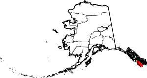 | |
| CDPs | ||
| Unincorporated community | ||
| Indian reservation | ||