Pasture Point Historic District
|
Pasture Point Historic District | |
 | |
  | |
| Location | Bounded by Hampton River on the east, Bright's Creek on the north, Wine St. on the west, and Syms St. on the south, Hampton, Virginia |
|---|---|
| Coordinates | 37°01′56″N 76°20′26″W / 37.03222°N 76.34056°WCoordinates: 37°01′56″N 76°20′26″W / 37.03222°N 76.34056°W |
| Area | 28 acres (11 ha) |
| Built | 1885-1919 |
| Architect | Multiple |
| Architectural style | Prairie School, Bungalow/Craftsman |
| NRHP reference # | 08000940[1] |
| VLR # | 114-0118 |
| Significant dates | |
| Added to NRHP | October 22, 2012 |
| Designated VLR | June 19, 2008[2] |
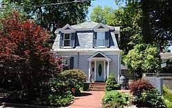
Pasture Point Historic District is a national historic district located at Hampton, Virginia. The district encompasses 110 contributing buildings in a streetcar suburb of Hampton platted in 1885. The residences include notable examples of the Late Victorian, Prairie School, and Bungalow styles. The district was largely developed by 1919, with some later infill dwellings.[3]
It was listed on the National Register of Historic Places in 2012.[1]
References
- 1 2 "National Register of Historic Places Listings". Weekly List of Actions Taken on Properties: 10/22/12 through 10/27/12. National Park Service. 2012-11-02.
- ↑ "Virginia Landmarks Register". Virginia Department of Historic Resources. Retrieved 19 March 2013.
- ↑ Jill Dowling; Robert J. Taylor Jr. & Danielle Worthing (2012). "National Register of Historic Places Inventory/Nomination: Pasture Point Historic District" (PDF). Virginia Department of Historic Resources. and Accompanying map


This article is issued from
Wikipedia.
The text is licensed under Creative Commons - Attribution - Sharealike.
Additional terms may apply for the media files.