Pamunkey Indian Reservation
| Pamunkey Indian Reservation, Virginia | ||
|---|---|---|
| Indian reservation | ||
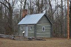 Replica cabin near the reservation entrance | ||
| ||
 Pamunkey Location within the Commonwealth of Virginia  Pamunkey Pamunkey (the US) | ||
| Coordinates: 37°34′29″N 77°0′5″W / 37.57472°N 77.00139°WCoordinates: 37°34′29″N 77°0′5″W / 37.57472°N 77.00139°W | ||
| Country | United States | |
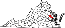
| State | Virginia | |
| County | King William | |
| Established | 1658 | |
| Government | ||
| • Chief | Robert Gray [1] | |
| Area | ||
| • Total | 1.9 sq mi (4.8 km2) | |
| • Land | 1.1 sq mi (2.8 km2) | |
| • Water | 0.8 sq mi (2.0 km2) | |
| Elevation | 10 ft (3 m) | |
| Population (2012) | ||
| • Total | 80 | |
| • Density | 42.1/sq mi (16.7/km2) | |
| Time zone | UTC-5 (Eastern (EST)) | |
| • Summer (DST) | UTC-4 (EDT) | |
| ZIP code | 23806 | |
| Area code(s) | 804 | |
| Website |
www | |
|
Pamunkey Indian Reservation Archaeological District | ||
|
| ||
| Nearest city | Lanesville, Virginia | |
| Area | 1,700 acres (690 ha) | |
| NRHP reference # | 82004567[2] | |
| Added to NRHP | September 16, 1982 | |
The Pamunkey Indian Reservation is a Native American reservation located in King William, Virginia, United States. The reservation lies along the Pamunkey River in King William County, Virginia on the Middle Peninsula. The Pamunkey Reservation contains approximately 1,200 acres (4.8 km²) of land, 500 acres (2 km²) of which is wetlands with numerous creeks. Thirty-four families reside on the reservation and many Tribal members live in nearby Richmond, Newport News, and other parts of Virginia.
History
The reservation was confirmed to the Pamunkey tribe as early as 1658 by the Governor, the Council, and the General Assembly of Virginia. The treaty of 1677 between the King of England, acting through the Governor of Virginia, and several Native American tribes including the Pamunkey is the most important existing document describing Virginia's relationship towards Indian land. The Pamunkey tribe early ancestors had locations as far north as the Middle Peninsula of Virginia and as far south as South Hampton Roads in Virginia. A burial mound, reported to contain the remains of Chief Powhatan, Father of Pocahontas (real name Matoaka), is also located on this Reservation next to railroad tracks. His brother Opechancanough relocated his remains here. He is also buried here.
References
- Virginia's First People: Past and Present, virginiaindians.pwnet.org
- ↑ "Contact". Retrieved 22 September 2016.
- ↑ National Park Service (2010-07-09). "National Register Information System". National Register of Historic Places. National Park Service.
- ↑ Anonymous (23 November 2009). "Telling the Story: Illuminating Native Heritage through Photography". Retrieved 22 September 2016.