Palos Verdes Peninsula
| Palos Verdes Peninsula, California | |
|---|---|
| Sub-region of the Los Angeles metropolitan area | |
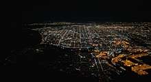
.jpg) Aerial view of the Palos Verdes Peninsula and the Palos Verdes Hills, with Los Angeles in the distance | |
| Country |
|
| State |
|
| County |
|
| Time zone | PST |
| • Summer (DST) | PDT |
| Area code(s) | 310, 424 |
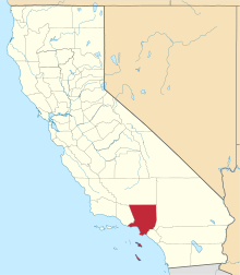
The Palos Verdes Peninsula (from Spanish Palos Verdes: Green sticks) is a landform and a geographic sub-region of the Los Angeles metropolitan area, within southwestern Los Angeles County in the U.S. state of California. Located in the South Bay region, the peninsula contains a group of affluent cities in the Palos Verdes Hills, including Palos Verdes Estates, Rancho Palos Verdes, Rolling Hills and Rolling Hills Estates. The South Bay city of Torrance borders the peninsula on the north, the Pacific Ocean is on the west and south, and the Port of Los Angeles is east.
The hill cities on the peninsula are known for dramatic ocean and city views, distinguished schools,[1] extensive horse trails,[2] and high value homes.[3]
History
American Indians
The peninsula was the homeland of the Tongva-Gabrieliño Native Americans people for thousands of years. In other areas of the Los Angeles Basin archeological sites date back 8,000 years.[4][5] Their first contact with Europeans occurred in 1542 with João Cabrilho (Juan Cabrillo). Chowigna and Suangna were two Tongva settlements of many in the peninsula area, which was also a departure point for their rancherías on the Channel Islands.
Spanish and Mexican era
In 1846 José Dolores Sepúlveda and José Loreto received a Mexican land grant from Alta California Governor Pío Pico for a parcel from the huge original 1784 Spanish land grant of Rancho San Pedro to Manuel Dominguez.[6] It was named Rancho de los Palos Verdes, or "ranch of the green sticks", which was used primarily as a cattle ranch.[7] It was also a whaling station in the mid-19th century, albeit only for a brief period.
American era
By 1882 ownership of the land had passed from the Sepulveda family through various mortgage holders to Jotham Bixby of Rancho Los Cerritos, who leased the land to Japanese farmers.[8]
Frank Vanderlip, representing a group of wealthy east coast investors, purchased 25 square miles of land on the Palos Verdes Peninsula in 1913 for $1.5 million.[9] In 1914, Vanderlip vacationed at Palos Verdes in order to recover from an illness, and he was astounded by scenery he compared to "the Sorrentine Peninsula and the Amalfi Drive." He quickly initiated development of Palos Verdes. He hired the Olmsted Brothers, the landscaping firm of John Charles Olmsted and Frederick Law Olmsted, Jr., to plan and landscape a new subdivision. The Olmsted Brothers contracted Koebig & Koebig to perform engineering work, including surveying and road planning.[10] However, the project stalled as World War I started, and Vanderlip accepted a chairmanship to the War Savings Committee in Washington, D.C. in 1916.
By 1921, Vanderlip had lost interest in overseeing development of Palos Verdes and enticed Edward Gardner Lewis to take over the project with an option to buy the property for $5 million. Lewis was an experienced developer, but lacked the capital to purchase and develop Palos Verdes. Instead, he established a real estate trust, capitalizing the project through the sale of notes which were convertible to Palos Verdes property. Under the terms of the trust, Lewis sought to raise $30 million for infrastructure improvements, effectively borrowing from investors for both the land and the improvements. He succeeded in attracting $15 million in capital, but far short of the $35 million needed. The trust dissolved and ownership of Palos Verdes reverted to Vanderlip.[11]
Vanderlip established a new real estate trust to purchase 3200 acres from his land syndicate and establish the subdivision of Palos Verdes Estates. The new trust assumed not just the land, but also the improvements made by Lewis. They were not complete, but they were substantial: many sewers, water mains, and roads; landscaping, parks, and a golf course. They opened Palos Verdes for public inspection in June 1923.[12]
Palos Verdes Estates was organized and landscaped by the Olmsted Brothers and in their planning, they dedicated a quarter of the land area to permanent open undeveloped space, giving the subdivision its unique rural characteristic and culture of scenic beauty.[13]
Somewhat recently, around the 1980s, Rancho Palos Verdes acquired Eastview, a formerly unincorporated neighborhood of L.A. County with a San Pedro ZIP Code.
Commerce
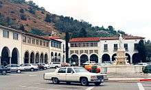
Areas of commerce include historic Mediterranean Revival style Malaga Cove Plaza, the Promenade on the Peninsula. Smaller shopping centers include the Peninsula Center, Lunada Bay Plaza and Golden Cove Plaza.
The largest peninsula commercial district is in Rolling Hills Estates, with many shopping centers including The Promenade on the Peninsula with a megaplex movie theater and an ice rink.
The Palos Verdes area has beautiful ocean views, coastline views and city light views.
Transportation
The Palos Verdes Peninsula Transit Authority provides bus service within and to the Palos Verdes Peninsula.[14] The Palos Verdes Peninsula is within 40 minutes of both Los Angeles International Airport and Long Beach Airport, which together provide access to most of the United States aboard all major carriers.
Education
.jpg)
The Palos Verdes Peninsula Unified School District has one of the highest rated API scores in California[15] and has one of the highest average SAT scores[16] and one of the highest percentage of students successfully completing the Advanced Placement exams[17] in the county. There are three high schools, Palos Verdes Peninsula High School (formerly called Rolling Hills High School), Palos Verdes High School, and Rancho Del Mar High School (located in Rolling Hills). Marymount California University, a co-ed Roman Catholic four-year college is located in Rancho Palos Verdes. A private K–12 school, Chadwick School, is also located there. Rolling Hills Country Day School, adjacent to the Botanic Garden, offers a private K-8 education. In summary, there are 11 elementary schools, 3 intermediate schools, and 3 high schools located on the peninsula.
In the Eastview neighborhood of Rancho Palos Verdes, however, residents have the option to choose either PV schools or the surrounding LAUSD schools (i.e. Dodson Middle School, Dana Middle School, San Pedro High School, etc.).
Libraries
The Peninsula is served by the Palos Verdes Library District which operates the:
- Peninsula Center Library
- Miraleste Library
- Malaga Cove Library- on the National Historical Register
Parks and recreation

.jpg)
- South Coast Botanic Garden – 35 hectare (87 acre) landscaped botanical garden, event venue, and arboretum with over 150,000 landscape plants and trees from approximately 140 families, 700 genera, and 2,000 different species. It is a classic example of land recycling by reclaiming a site that was previously a sanitary landfill and open pit diatomite mine from 1929 until 1956.[18]
- Point Vicente Park is a popular spot for watching the migration of gray whales to and from their breeding lagoon in Baja California.
- Fort MacArthur Military Museum is located near Point Fermin in San Pedro.
- Del Cerro Park Trails is a popular hiking trail at end of Crenshaw Road.
- Ryan Park This park is Rancho Palos Verdes's first established park in the city, overlooking a view of nearby island Catalina. Park features include baseball diamond, picnic areas with barbecue, and a community room.[19]
The peninsula is frequented by runners, hikers, horseback riders, bird watchers, surfers, scuba divers, fishermen, and bicyclists. The area is home to several golf courses and country clubs. In addition, nude sunbathers formerly frequented Sacreds Cove (or "Smugglers Cove") until the city of Rancho Palos Verdes enacted a 1994 ordinance that ended such use of that beach.
The infamous Palos Verdes surf spots have been in the spotlight many times over issues of "localism". The most notorious surf spot for localism in Palos Verdes is Lunada Bay, which can hold any winter swell and has been known to rival Sunset Beach, Hawaii on a big day. Localism in Palos Verdes reached a turning point in 2001 when a civil rights lawsuit was filed after a particularly violent confrontation with Hermosa Beach surfers.[20] Surveillance cameras were placed in the surfing area but were later removed.[21] In 2016, The Coastal Commission targeted the group after "renewed reports that their un-permitted structure [built along Lunada Bay] was being used as a spot for ongoing bullying and intimidation." On July 12, 2016, City Manager Tony Dahlerbruch is recommending the removal of the illegal structure after pressure from the California Coastal Commission.[22]
The Trump National Golf Club is a Donald Trump venture with a golf course on the Ocean Trails cliffs. The 18th hole of the prior golf course fell victim to a landslide caused by a leak in the sanitary pipes underneath it. In the summer of 2006, the golf club erected a 70-foot flagpole for an American flag; critics claimed it was illegal, but the golf club was allowed to retain it after a City Council vote.[23]
The Marineland of the Pacific site near Portuguese Bend is currently home of Terranea, a luxury oceanfront resort.[24]
There are numerous nature reserves in Palos Verdes, which attribute to the area's unique natural property. Palos Verdes Estates Shoreline Preserve, Agua Amarga Reserve, and Portuguese Bend Reserve. The reserves contain coastal sage scrubs habitats, a community of fragrant and drought resistant shrubs and flowering plants. In August 2009, wildfire burned approximately 165-acres of the Portuguese Bend Reserve. As a result, in recent years, restoration has been done to reinstall native plants and animals to the area.[25]
Native plants
Native animals
Notable places

- The Wayfarers Chapel, a transparent glass chapel in a redwood forest, was designed in 1951 by the renowned architect and landscape architect Lloyd Wright. It is under the stewardship of the Swedenborgian Church, a well-known landmark on the National Register of Historic Places, and overlooking the ocean at the western entrance of Portuguese Bend.
- Portuguese Bend is one of the most geologically unstable areas in the world. Constant shifting of the soil (approximately 1/3 of an inch a day) and rock slides mean that Palos Verdes Drive South, the main road through the bend, is under constant repair.
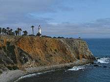
- Point Vicente Lighthouse is on the National Register of Historic Places.
- Korean Bell of Friendship is located near Point Fermin in San Pedro.
- Marineland of the Pacific is the location of the former aquatic theme park on the coast.
- MTV Beach House. Fox filmed some scenes of its teen drama, The OC, at locations in and around Palos Verdes.[27]
Wrecks
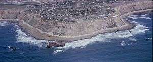
- The wreck of the SS Dominator, a freighter that ran aground in 1961, was for years an attraction for those willing to hike down the cliffs to the shoreline. Very little is left of the ship today.
- In 2006, the 45-foot cabin cruiser Lady Hawk sank two miles from the Palos Verdes coast due to an engine fire.[28]
Notable people
|
See also
- Horse community
- Palos Verdes blue—an endangered species of endemic butterfly of the Palos Verdes Peninsula
- Palos Verdes Peninsula Land Conservancy
- Peninsula—including a list of peninsulas
- Transverse Ranges—with the Palos Verdes Hills and Channel Islands a single geologic range.
Climate
According to the Köppen Climate Classification system, Palos Verdes has a Mediterranean climate, abbreviated "Csa" on climate maps.[30]
References
- ↑ "Palos Verdes Peninsula High School Profile" (PDF). Palos Verdes Peninsula School District. Archived from the original (PDF) on 2006-09-25. Retrieved 2006-10-03.
- ↑ "Rancho Palos Verdes Equestrian Maps". City of Rancho Palos Verdes. Retrieved 2006-10-03.
- ↑ "The Most Expensive ZIP Codes". Forbes. Archived from the original on January 24, 2007. Retrieved 2006-10-03.
- ↑ laokay: History of Rancho Los Encinos. accessed 8/20/2010
- ↑ "USATODAY.com - Prehistoric milling site found in California". www.usatoday.com. Retrieved 2017-10-24.
- ↑ "Plat of the Rancho Los Palos Verdes [Calif.] : finally confirmed to Jose Loretto Sepulveda et al. / surveyed under instructions from the U.S. Surveyor General by Henry Hancock, Dep. Survr., September 1859". Calisphere. Retrieved 2017-10-24.
- ↑ Ogden Hoffman, 1862, Reports of Land Cases Determined in the United States District Court for the Northern District of California, Numa Hubert, San Francisco
- ↑ Gnerre, Sam (March 2, 2010). "Bixby Ranch". South Bay History. South Bay Daily Breeze. Retrieved 12 June 2015.
- ↑ Robert M. Fogelson (2005). Bourgeois Nightmares: suburbia, 1870–1930 New Haven: Yale University Press, p.5-6.
- ↑ Robert M. Fogelson (2005). Bourgeois Nightmares: Duburbia, 1870–1930. New Haven: Yale University Press, pp. 6–8.
- ↑ Robert M. Fogelson (2005). Bourgeois Nightmares: Duburbia, 1870–1930. New Haven: Yale University Press, pp. 8–10.
- ↑ Robert M. Fogelson (2005). Bourgeois Nightmares: Duburbia, 1870–1930. New Haven: Yale University Press, p. 10.
- ↑ "History of PVE | Palos Verdes Estates, CA". www.pvestates.org. Retrieved 2017-10-24.
- ↑ "Palos Verdes Peninsula Transit Authority". www.palosverdes.com. Retrieved 2017-10-24.
- ↑ "Palos Verdes Local Educational Agency Report". California Department of Education. Retrieved 2006-10-03.
- ↑ "School Wise Press School Snapshot: Palos Verdes Peninsula High School". School Wise Press. Archived from the original on 2006-10-24. Retrieved 2006-10-03.
- ↑ "SAT, ACT and AP Test Results in California". California Department of Education. Retrieved 2006-10-03.
- ↑ "History & Mission - South Coast Botanic Garden Foundation". South Coast Botanic Garden Foundation. Retrieved 2017-10-24.
- ↑ "Facilities". www.rpvca.gov. Rancho Palos Verde City Hall. Retrieved 28 July 2016.
- ↑ Swellmagnet.com
- ↑ Austlii.edu.au
- ↑ Therolf, Garrett. "Surfer gang's Lunada Bay 'fort' must go, city staff says". Los Angeles Times. Retrieved 28 July 2016.
- ↑ "Trump Gets OK for Illegal Flagpole". 2006-09-21. ISSN 0190-8286. Retrieved 2017-10-24.
- ↑ "California Luxury Oceanfront Resorts | Terranea Resort | Eco Resorts in Southern California". www.terranea.com. Retrieved 2017-10-24.
- ↑ Conservancy, Palos Verdes Peninsula Land. "Lands: Palos Verdes Nature Preserve – Portuguese Bend Reserve | Palos Verdes Peninsula Land Conservancy". www.pvplc.org. Retrieved 2016-09-11.
- 1 2 3 4 5 Ph.D., Christine M. Rodrigue,. "Palos Verdes native plant key". www.csulb.edu. Retrieved 2016-09-11.
- ↑ GJW. "THE O.C. Filming Locations: Palos Verdes". www.seeing-stars.com. Retrieved 2017-10-24.
- ↑ "NBC4 – Trending news and topics". www.nbc4.tv. Retrieved 2017-10-24.
- ↑ Beale, Lauren (2011-07-01). "Anderson da Silva buys Palos Verdes Estate home". Los Angeles Times. Retrieved 20 July 2011.
- ↑ "Palos Verdes Estates, California Climate". www.bestplaces.net. Retrieved 2017-10-24.
Further reading
- Patryla, Jim (2005). A Photographic Journey Back to Marineland of the Pacific. Lulu Publishing. ISBN 978-1-4116-7130-0.
External links
| Wikimedia Commons has media related to Palos Verdes. |
| Wikivoyage has a travel guide for Palos Verdes. |
- Official Palos Verdes Library District
- Palos Verdes Daily Photo blog
- Official South Coast Botanical Garden
- Palos Verdes Peninsula Chamber of Commerce & Visitor's Center
Population - 12,874,797 | ||
| Counties |  | |
| Major city 3.8 million | ||
| Cities over 250K | ||
| Cities and towns 100k-250k | ||
| Bodies of water | ||
| Regions |
| |

Coordinates: 33°45′31″N 118°20′45″W / 33.7586472222°N 118.345844444°W