Huntington Park, California
| Huntington Park, California | ||
|---|---|---|
| City in California | ||
| City of Huntington Park | ||
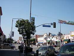 Pacific Boulevard and Clarendon Avenue, 2009 | ||
| ||
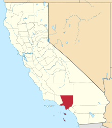
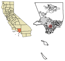 Location of Huntington Park in Los Angeles County, California. | ||
 Huntington Park, California Location in the United States | ||
| Coordinates: 33°59′N 118°13′W / 33.983°N 118.217°WCoordinates: 33°59′N 118°13′W / 33.983°N 118.217°W | ||
| Country |
| |
| State |
| |
| County | Los Angeles | |
| Incorporated | September 1, 1906[1] | |
| Government | ||
| • Type | Council–manager[2] | |
| • Mayor | Jhonny Pineda [2] | |
| Area[3] | ||
| • Total | 3.02 sq mi (7.81 km2) | |
| • Land | 3.01 sq mi (7.80 km2) | |
| • Water | 0.00 sq mi (0.01 km2) 0.11% | |
| Elevation[4] | 171 ft (52 m) | |
| Population (2010)[5] | ||
| • Total | 58,114 | |
| • Estimate (2016)[6] | 58,879 | |
| • Density | 19,541.65/sq mi (7,546.21/km2) | |
| Time zone | UTC-8 (Pacific) | |
| • Summer (DST) | UTC-7 (PDT) | |
| ZIP code | 90255[7] | |
| Area code | 323[8] | |
| FIPS code | 06-36056 | |
| GNIS feature IDs | 1660778, 2410079 | |
| Website |
www | |
Huntington Park is a city in the Gateway Cities district of southeastern Los Angeles County, California.
As of the 2010 census, the city had a total population of 58,114, down from 61,348 at the 2000 census.
History
Named for prominent industrialist Henry E. Huntington, Huntington Park was incorporated in 1906 as a streetcar suburb for workers in the rapidly expanding industries to the southeast of downtown Los Angeles. To this day, about 30% of its residents work at factories in nearby Vernon and Commerce.[9] The stretch of Pacific Boulevard in downtown Huntington Park was a major commercial district serving the city's largely working-class residents, as well as those of neighboring cities such as Bell, Cudahy, South Gate, and Downey. As with most of the other cities along the corridor stretching along the Los Angeles River to the south and southeast of downtown Los Angeles, Huntington Park was an almost exclusively white community during most of its history; Alameda Street and Slauson Avenue, which were fiercely defended segregation lines in the 1950s, separated it from black areas.
The changes that shaped Los Angeles from the late 1970s onward—the decline of American manufacturing that began in the 1970s; the rapid growth of newer suburbs in Orange County, the eastern San Gabriel, western San Fernando and Conejo valleys; the collapse of the aerospace and defense industry at the end of the Cold War; and the implosion of the Southern California real estate boom in the early 1990s—resulted in the wholesale departure of virtually all of the white population of Huntington Park by the mid-1990s. The vacuum was filled almost entirely by two groups of Latinos: upwardly mobile families eager to leave the barrios of East Los Angeles, and recent Mexican immigrants. Today, Pacific Boulevard is once again a thriving commercial strip, serving as a major retail center for working-class residents of southeastern Los Angeles County—but unlike its previous heyday of the 1930s, the signs along the avenue's storefronts are now primarily in Spanish.
Geography
Before California abolished judicial townships (some time after 1960), Huntington Park was located in San Antonio Township.
According to the United States Census Bureau, the city has a total area of 3.0 square miles (7.8 km2), all land.
Cities surrounding Huntington Park include Bell, Cudahy, Los Angeles, Maywood, South Gate, and Vernon. In addition unincorporated areas, including Florence-Graham and Walnut Park, are adjacent to Huntington Park.[10]
Climate
On average, there are 286 sunny days per year in Huntington Park, California. Annually the snowfall is 0 inches. The July high is around 82 degrees. The January low is 48.[11] As of 2015 the average high temperatures have risen raging from the low to mid 90's.[12]
Demographics
| Historical population | |||
|---|---|---|---|
| Census | Pop. | %± | |
| 1910 | 1,299 | — | |
| 1920 | 4,513 | 247.4% | |
| 1930 | 24,591 | 444.9% | |
| 1940 | 28,648 | 16.5% | |
| 1950 | 29,450 | 2.8% | |
| 1960 | 29,920 | 1.6% | |
| 1970 | 33,744 | 12.8% | |
| 1980 | 45,932 | 36.1% | |
| 1990 | 56,065 | 22.1% | |
| 2000 | 61,348 | 9.4% | |
| 2010 | 58,114 | −5.3% | |
| Est. 2016 | 58,879 | [6] | 1.3% |
| U.S. Decennial Census[13] | |||
2012
A 2012 study by the California Center for Public Health Advocacy found Huntington Park California had the highest percentage of overweight children in all of California with 53% of the city's child population being obese or overweight.[14]
2010 census
The 2010 United States Census[15] reported that Huntington Park had a population of 58,114. The population density was 19,270.0 people per square mile (7,440.2/km²). The racial makeup of Huntington Park was 56,445 (97.1%) Hispanic or Latino, 29,776 (51.2%) White (1.6% Non-Hispanic White), 440 (0.8%) African American, 752 (1.3%) Native American, 393 (0.7%) Asian, 28 (0.0%) Pacific Islander, 24,535 (42.2%) from other races, and 2,190 (3.8%) from two or more races.[16]
The Census reported that 57,859 people (99.6% of the population) lived in households, 248 (0.4%) lived in non-institutionalized group quarters, and 7 (0%) were institutionalized.
There were 14,597 households, out of which 8,581 (58.8%) had children under the age of 18 living in them, 7,461 (51.1%) were opposite-sex married couples living together, 3,212 (22.0%) had a female householder with no husband present, 1,623 (11.1%) had a male householder with no wife present. There were 1,377 (9.4%) unmarried opposite-sex partnerships, and 81 (0.6%) same-sex married couples or partnerships. 1,644 households (11.3%) were made up of individuals and 694 (4.8%) had someone living alone who was 65 years of age or older. The average household size was 3.96. There were 12,296 families (84.2% of all households); the average family size was 4.19.
The population was spread out with 18,439 people (31.7%) under the age of 18, 6,984 people (12.0%) aged 18 to 24, 17,886 people (30.8%) aged 25 to 44, 10,942 people (18.8%) aged 45 to 64, and 3,863 people (6.6%) who were 65 years of age or older. The median age was 28.9 years. For every 100 females, there were 99.6 males. For every 100 females age 18 and over, there were 97.8 males.
There were 15,151 housing units at an average density of 5,023.9 per square mile (1,939.7/km²), of which 3,936 (27.0%) were owner-occupied, and 10,661 (73.0%) were occupied by renters. The homeowner vacancy rate was 1.5%; the rental vacancy rate was 3.2%. 18,054 people (31.1% of the population) lived in owner-occupied housing units and 39,805 people (68.5%) lived in rental housing units.
During 2009–2013, Huntington Park had a median household income of $36,397, with 28.7% of the population living below the federal poverty line.[16]
2000 census
According to the census[17] of 2000, there were 61,348 people, 14,860 households, and 12,660 families residing in the city. The population density was 20,252.4 inhabitants per square mile (7,817.4/km²). There were 15,335 housing units at an average density of 5,062.4 per square mile (1,954.1/km²). The racial makeup of the city was 41.4% White, 0.8% Black or African American, 1.0% Native American, 0.80% Asian, 0.1% Pacific Islander, 51.1% from other races, and 4.9% from two or more races. 95.6% of the population were Hispanic or Latino of any race.
As of 2000, speakers of Spanish as their first language accounted for 90.77% of residents, while English was spoken by 9.17%, Chinese by 0.05% of the population.[18]
There were 14,860 households out of which 58.3% had children under the age of 18 living with them, 55.4% were married couples living together, 20.3% had a female householder with no husband present, and 14.8% were non-families. 10.9% of all households were made up of individuals and 4.8% had someone living alone who was 65 years of age or older. The average household size was 4.12 and the average family size was 4.34.
In the city, the population was spread out with 35.8% under the age of 18, 13.0% from 18 to 24, 32.3% from 25 to 44, 13.8% from 45 to 64, and 5.1% who were 65 years of age or older. The median age was 26 years. For every 100 females, there were 100.3 males. For every 100 females age 18 and over, there were 98.3 males.
The median income for a household in the city was $28,941, and the median income for a family was $29,844. Males had a median income of $21,039 versus $16,733 for females. The per capita income for the city was $9,340. About 23.3% of families and 25.2% of the population were below the poverty line, including 31.5% of those under age 18 and 18.7% of those age 65 or over.
Arts and culture
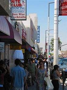
Pacific Boulevard
Architecture
Notable Streamline Moderne architecture includes the Lane-Wells Company Building and the W. W. Henry Company Building.[19][20] Art Deco architecture is found in Huntington Park's commercial district, and include the former theaters along Pacific Blvd.[21][22] The 1,468 seat Warner Theater on Pacific Boulevard opened in 1930, and was designed by B. Marcus Priteca.[23] The California Theatre opened in 1925 and was operated by Fox Theatres as the Fox California Theatre. In the 1980s it was known as the California 3 Theatre. The theatre closed in 2006 and was later converted into a retail space. It was renamed California 2 Theatres and now there is a tuxedo shop along with other retail stores and restaurants.[24]
Festival and fairs
Pacific Boulevard, the commercial business street of Huntington Park, has been the location for festivals, carnival fairs and parades. The "Carnaval Primavera" is held each year for three days across nine blocks of Pacific Boulevard in Huntington Park. The event features Central American and Mexican food, carnival rides, games, and live music.[25]
Public libraries
County of Los Angeles Public Library operates the Huntington Park Library.[26]
Government
In the California State Senate, Huntington Park is in the 33rd Senate District, represented by Democrat Ricardo Lara.[27]
In the California State Assembly, Huntington Park is split between the 53rd Assembly District, represented by Democrat Miguel Santiago, and the 59th Assembly District, represented by Democrat Reggie Jones-Sawyer.[28]
In the United States House of Representatives, Huntington Park is in California's 40th congressional district, represented by Democrat Lucille Roybal-Allard.[29]
Education
Huntington Park is zoned to schools in the Los Angeles Unified School District.
Public elementary schools in Huntington Park include:
- Hope Street Elementary School[30]
- Huntington Park New Elementary[31]
- Middleton Elementary School and Middleton New Primary Center
- Miles Elementary School
- Pacific Boulevard School[32]
- San Antonio Elementary School
- Walnut Park Elementary School
- Lucille Roybal- Allard Elementary School[33]
- KIPP Comienza Community Prep
- Aspire: Antonio Maria Lugo Academy
- Aspire: Titan Academy
- Aspire: Junior Collegiate Academy
- Academia Moderna
Public middle schools include:
- Gage Middle School
- Nimitz Middle School
- Centennial College Preparatory Academy
- Aspire: Ollin University Preparatory Academy
- Walnut Park Middle School
- Prepa Tec
Public high schools include:
- Huntington Park High School
- Alliance Collins Family College Ready High School [34]
- Aspire Pacific Academy[35]
- Linda Esperanza Marquez High School
- Maywood Academy High School
- Alliance Margaret M. Bloomfield High School[36]
- Diego Rivera Learning Complex[37]
In addition Pacific Boulevard Special Education Center (ungraded) is in the city.
Private schools include:
- Church of the Nazarene School
- St. Matthias Catholic Elementary School[38]
- Interamerican Adult School
Infrastructure
Emergency services
Fire protection in Huntington Park is provided by the Los Angeles County Fire Department.[39] The Huntington Park Police Department provides law enforcement.
Transportation
Bus services are provided by both the Los Angeles County Metropolitan Transportation Authority, and Huntington Park's own COMBI bus service.
Notable people
- Lois Andrews - actress, notable for her portrayal of the comics character Dixie Dugan.
- Elton Gallegly - former US Representative, California's 24th District.
- Leon Leyson - youngest person on Schindler's List, taught at Huntington Park High School.[40]
- Rosario Marin - 41st Treasurer of the United States and a former mayor of Huntington Park.
- Lorenzo Mata - professional basketball player.
- Jeremy McKinney - professional football player.
- Tim Wallach - professional baseball player.
- Terry Wilson - stuntman and actor, noted for his role as "Bill Hawks" on the television series Wagon Train.
- Tex Winter - basketball coach.
See also
References
- ↑ "California Cities by Incorporation Date". California Association of Local Agency Formation Commissions. Archived from the original (Word) on November 3, 2014. Retrieved August 25, 2014.
- 1 2 "Huntington Park! - City Council". Retrieved March 31, 2015.
- ↑ "2016 U.S. Gazetteer Files". United States Census Bureau. Retrieved Jul 19, 2017.
- ↑ "Huntington Park". Geographic Names Information System. United States Geological Survey. Retrieved January 22, 2015.
- ↑ "Huntington Park (city) QuickFacts". United States Census Bureau. Archived from the original on March 31, 2015. Retrieved April 6, 2015.
- 1 2 "Population and Housing Unit Estimates". Retrieved June 9, 2017.
- ↑ "USPS - ZIP Code Lookup - Find a ZIP+ 4 Code By City Results". Retrieved January 18, 2007.
- ↑ "Number Administration System - NPA and City/Town Search Results". Archived from the original on September 26, 2007. Retrieved January 18, 2007.
- ↑ http://factfinder.census.gov/ Archived May 21, 2008, at the Wayback Machine. Factfinder.census.gov
- ↑ "Zoning Map." City of Huntington Park. Retrieved on December 6, 2008.
- ↑ "Climate in Huntington Park, California".
- ↑ "Temperatures have risen in nearly every US state since 1900".
- ↑ "Census of Population and Housing". Census.gov. Archived from the original on May 12, 2015. Retrieved June 4, 2015.
- ↑ "Archived copy" (PDF). Archived from the original (PDF) on July 28, 2013. Retrieved July 24, 2012.
- ↑ "2010 Census Interactive Population Search: CA - Huntington Park city". U.S. Census Bureau. Retrieved July 12, 2014.
- 1 2 "Huntington Park (city) QuickFacts from the US Census Bureau". census.gov. Archived from the original on March 31, 2015. Retrieved January 19, 2015.
- ↑ "American FactFinder". United States Census Bureau. Archived from the original on September 11, 2013. Retrieved January 31, 2008.
- ↑ "Data Center Results - Huntington Park, California". Modern Language Association. Retrieved November 18, 2009.
- ↑ "California Art Deco & Streamline Moderne Buildings (page 3)". Archived from the original on 2015-01-20.
- ↑ "Lane-Wells Company headquarters in Los Angeles, circa 1939".
- ↑ [hhttps://losangelestheatres.blogspot.com/2017/08/california-theatre.html "California Theatre"].
- ↑ Kinsey, James (12/05/2007). Huntington Park. Arcadia Publishing SC. p. 130. ISBN 9781531628703. Check date values in:
|year=(help) - ↑ "southonspring.com/warner-huntington-park/".
- ↑ "California Theatre". losangelestheatres.blogspot.com. Retrieved September 15, 2018.
- ↑ "Huntington Park Carnaval Primavera".
- ↑ "Huntington Park Library." County of Los Angeles Public Library. Retrieved on December 6, 2008.
- ↑ "Statewide Database". UC Regents. Retrieved November 6, 2014.
- ↑ "Communities of Interest - City". California Citizens Redistricting Commission. Archived from the original on October 23, 2015. Retrieved November 6, 2014.
- ↑ "California's 40th Congressional District - Representatives & District Map". Civic Impulse, LLC. Retrieved October 5, 2014.
- ↑ "Project Details". laschools.org. Retrieved January 29, 2015.
- ↑ "Project Details". laschools.org. Retrieved January 29, 2015.
- ↑ "Project Details". laschools.org. Retrieved January 29, 2015.
- ↑ "Lucille Roybal Allard Elementary School: Founders". allardes-lausd-ca.schoolloop.com. Retrieved 2018-02-08.
- ↑ "Alliance Collins Family College Ready High School". www.collinsfamilyjaguars.org. Retrieved October 27, 2015.
- ↑ "Aspire Pacific Academy High School". www.aspirepacificacademy.org. Retrieved March 21, 2018.
- ↑ "Alliance Margaret M. Bloomfield High School". www.bloomfieldhs.org. Retrieved October 27, 2015.
- ↑ "Diego Rivera Learning Complex: Home Page". drlc-lausd-ca.schoolloop.com. Retrieved October 27, 2015.
- ↑ "SAINT MATTHIAS SCHOOL - HUNTINGTON PARK'S DUAL LANGUAGE IMMERSION CATHOLIC SCHOOL". SAINT MATTHIAS SCHOOL - HUNTINGTON PARK'S DUAL LANGUAGE IMMERSION CATHOLIC SCHOOL.
- ↑ "Hometown Fire Stations Archived September 13, 2007, at the Wayback Machine.." Los Angeles County Fire Department. Retrieved on December 6, 2008.
- ↑ "Leon Leyson's Life Featured in 'A Child on Schindler's List,'" NBC Los Angeles (July 22, 2009).
External links
| Wikimedia Commons has media related to Huntington Park, California. |