Moorpark, California
| City of Moorpark | |||
|---|---|---|---|
| City in California | |||
 | |||
| |||
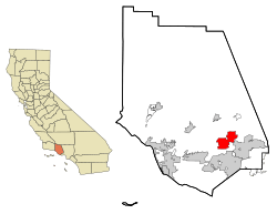 Location in Ventura County and the state of California | |||
 City of Moorpark Location in the United States | |||
| Coordinates: 34°16′52″N 118°52′25″W / 34.28111°N 118.87361°WCoordinates: 34°16′52″N 118°52′25″W / 34.28111°N 118.87361°W | |||
| Country | United States | ||
| State | California | ||
| County | Ventura | ||
| Founded | 1887 | ||
| Incorporated | 1983-07-01[1] | ||
| Government | |||
| • Type | Council-Manager[2] | ||
| • Mayor | Janice S. Parvin[3] | ||
| • State Senator | Henry Stern (D)[4] | ||
| • Assemblymember | Jacqui Irwin (D)[4] | ||
| • U. S. Congress | Julia Brownley (D)[5] | ||
| Area[6] | |||
| • Total | 12.80 sq mi (33.15 km2) | ||
| • Land | 12.58 sq mi (32.58 km2) | ||
| • Water | 0.22 sq mi (0.57 km2) 1.72% | ||
| Elevation[7] | 515 ft (157 m) | ||
| Population (2010)[8] | |||
| • Total | 34,421 | ||
| • Estimate (2016)[9] | 36,481 | ||
| • Density | 2,900.15/sq mi (1,119.74/km2) | ||
| Time zone | UTC-8 (PST) | ||
| • Summer (DST) | UTC-7 (PDT) | ||
| Zip Code | 93021-2804 (General Delivery), 93020 (P.O. Box)[10] | ||
| Area code(s) | 805[11] | ||
| FIPS code | 06-49138 | ||
| GNIS feature ID | 1652754 | ||
| Website |
www | ||


Moorpark is a city in Ventura County in Southern California. Moorpark was founded in 1900 when the application for the Moorpark Post Office was approved and Inocencio C. Villegas was named Moorpark's first postmaster on August 8 of that year. The townsite of Moorpark was owned and surveyed by Robert W. Poindexter and his wife, Madeline. The town has experienced a great amount of growth since the late 1970s. The population was 34,421 at the 2010 census, up from 31,415 at the 2000 census.
Etymology
The origin of the name "Moorpark" is unknown, but several sources have been suggested. Of these most sources agree that its origin was Admiral Lord Anson's estate Moor Park in Hertfordshire, England where he introduced the apricot in 1688.[12][13][14]
It is mainly believed that the town of Moorpark is named after the Moorpark apricot, which used to grow in the area.[15]
One other theory of the name is that when the Southern Pacific Railroad was surveying the local land in the 19th century for its railway, someone in the party said that the area, with its sloping hills, looked like the Scottish Moors. Hence the name Moorpark.
History
Chumash people were the first to inhabit what is now known as Moorpark. A Chumash village, known as Quimisac (Kimishax), was located in today’s Happy Canyon Regional Park. They were hunters and gatherers who often traveled between villages to trade. The village of Quimisac once controlled the local trade of fused shale in the region.[16][17] The area was later part of the large Rancho Simi land grant given in 1795 to the Pico brothers (Javier, Patricio, and Miguel) by Governor Diego de Borica of Alta California.
Robert W. Poindexter, the secretary of the Simi Land and Water Company, received the land when the association was disbanded. A map showing the townsite was prepared in November 1900. It was a resubdivision of the large lot subdivision known as Fremont, or Fremontville.[18][19] An application for a post office was submitted on June 1, 1900 and approved by August of that year. The application noted that the town had a railroad depot.[20] The town grew after the 1904 completion of a 7,369-foot (2,246 m) tunnel through the Santa Susana Mountains. Moorpark was then on the main route of the Southern Pacific Railroad's Coast Line between Los Angeles and San Francisco. The depot remained in operation until it was closed in 1958. It was eventually torn down around 1965.
Moorpark was one of the first cities to run off commercial nuclear power in the entire world, and the second in the United States, after Arco, Idaho on July 17, 1955, which is the first city in the world to be lit by atomic power. For one hour on November 12, 1957, this fact was featured on Edwin R. Murrow's "See It Now" television show.[21] The reactor, called the Sodium Reactor Experiment was built by the Atomics International division of North American Aviation at the nearby Santa Susana Field Laboratory. The Sodium Reactor Experiment operated from 1957 to 1964 and produced 7.5 megawatts of electrical power at a Southern California Edison-supplied generating station.[22]
Moorpark College opened on September 11, 1967. Moorpark College is one of the few colleges that features an Exotic Animal Training and Management Program. Moorpark was incorporated as a city on July 1, 1983.
In 1996, Moorpark's Little League All-Star team represented the West Region in the Little League World Series in Williamsport, PA.
In February 2005, a Siberian tiger named Tuffy that escaped from a local residence was shot and killed in one of Moorpark's parks. This created a great deal of uproar, because the animal control officers used a gun instead of a tranquilizer to kill the tiger, primarily because the tiger could not be shot from the proper angle for a tranquilizer to prove effective. Candlelight vigils were held for the late Tuffy. The couple who owned the tiger had moved from a licensed facility in Temecula, California, to an unlicensed facility in the Moorpark area of Ventura County. They lost their U.S. Department of Agriculture exhibitor license because they failed to notify the department of the move within 10 days. The wife pleaded guilty to a federal misdemeanor count of failing to maintain records of exotic felines. The husband pleaded guilty to obstruction of justice, making false statements and failing to maintain proper records.[23] Each was sentenced to home detention, three years probation, and fined $900.[24]
Just a month later, in March 2005, the fairly complete remains (about 75%) of an unusually old mammoth, possibly the rare southern mammoth (Mammuthus meridionalis), were discovered in the foothills of Moorpark at the site of a housing development.[25]
In 2006, the Moorpark city council transferred governance of their library from the Ventura County library system to their own newly created city library system. The library, which opened in 1912, celebrated its centennial in 2012.[26]
On February 28, 2006, a housing proposal, North Park Village, which would have added 1,680 houses on 3,586 acres (15 km2) in the north-east area of the city, was defeated by a landslide in a city election.[27]
In 2016, Mike Winters, the Vice President and Historian of the Moorpark Historical Society, published a revised history of Moorpark that covers the years from Moorpark's beginnings to the 1930s. The book, published by Arcadia Publishing is entitled Images of America: Moorpark.
City divisions and neighborhoods
Over 75 percent of homes in Moorpark were constructed after 1980.[15]
- "Old Town Moorpark" is the area surrounding High Street, and is the historic center of the city. A feature of the downtown area are the pepper trees that line High Street, planted by Robert Poindexter who was responsible for the plotting and mapping of the town. This area also features the High Street Arts Center (a Performing Arts center operated by the City of Moorpark), and various restaurants and businesses.
- The Peach Hill and Mountain Meadows neighborhoods are south of the Arroyo Simi, and most of the homes here were built within the last 30 years. Moorpark High School is in this area, as well as many parks, including the Arroyo Vista Park and Recreation Center, the city's largest park. This area contains a large part of the city's population.
- Campus Park is named for Moorpark College. An additional substantial development is occurring to the north of the existing city, in the area of the Moorpark Country Club.
Transportation
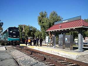
- The city is serviced by Amtrak California's Pacific Surfliner and Metrolink's Ventura County Line commuter rail, with a train station located on High Street, in the center of the city. Metrolink offers a commute rail to Los Angeles.[28]
- The city of Moorpark has a mass transit bus system, known as the Moorpark City Transit.
Economy
Most businesses are located in Old Town Moorpark and on Los Angeles Avenue.[15]
Top employers
According to the City's 2016 Comprehensive Annual Financial Report,[29] the top employers in the city are:
| # | Employer | # of Employees (2012) |
|---|---|---|
| 1 | PennyMac Loan Services | 1,142 |
| 2 | Moorpark Unified School District | 793 |
| 3 | Moorpark College | 672 |
| 4 | Benchmark Electronics Manufacturing Solutions | 275 |
| 5 | Pentair Water Pool & Spa | 256 |
| 6 | Muranaka Farm, Inc. | 250 |
| 7 | Target | 142 |
| 8 | Ensign-Bickford Aerospace & Defense | 121 |
| 9 | Test Equity LLC | 121 |
| 10 | Picnic Time, Inc. | 120 |
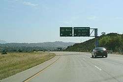
Major highways
Geography
Moorpark is located at 34°16'52" North, 118°52'25" West (34.281056, -118.873561).[30]
Central Moorpark lies in a valley created by the Arroyo Simi river. It is situated on flatlands and mesas at the base of numerous hills. It is located immediately west of Simi Valley, California.[31]
The city is divided by Highway 118, locally known as Los Angeles Avenue. Old Town Moorpark (Downtown) is located north of the freeway. Many newer residential communities can be found south of the freeway.[15]
According to the United States Census Bureau, the city has a total area of 12.8 square miles (33 km2). 12.6 square miles (33 km2) of it is land and 0.2 square miles (0.52 km2) of it is water. The total area is 1.72% water.
Destinations from Moorpark | ||||||||||
|---|---|---|---|---|---|---|---|---|---|---|
| ||||||||||
Climate
With its close proximity to Los Angeles, Moorpark too has a Subtropical-Mediterranean climate (Köppen climate classification Csb on the coast, Csa inland), and receives just enough annual precipitation to avoid either Köppen's BSh or BSk (semi-arid climate) classification.
| Climate data for Moorpark, California | |||||||||||||
|---|---|---|---|---|---|---|---|---|---|---|---|---|---|
| Month | Jan | Feb | Mar | Apr | May | Jun | Jul | Aug | Sep | Oct | Nov | Dec | Year |
| Record high °F (°C) | 92 (33) |
92 (33) |
96 (36) |
105 (41) |
102 (39) |
106 (41) |
105 (41) |
105 (41) |
109 (43) |
108 (42) |
99 (37) |
99 (37) |
109 (43) |
| Average high °F (°C) | 69 (21) |
69 (21) |
71 (22) |
74 (23) |
75 (24) |
77 (25) |
81 (27) |
83 (28) |
82 (28) |
79 (26) |
74 (23) |
69 (21) |
75 (24) |
| Average low °F (°C) | 41 (5) |
43 (6) |
44 (7) |
46 (8) |
50 (10) |
53 (12) |
57 (14) |
56 (13) |
55 (13) |
50 (10) |
44 (7) |
41 (5) |
48 (9) |
| Record low °F (°C) | 25 (−4) |
26 (−3) |
25 (−4) |
30 (−1) |
35 (2) |
37 (3) |
38 (3) |
40 (4) |
40 (4) |
32 (0) |
28 (−2) |
25 (−4) |
25 (−4) |
| Average precipitation inches (mm) | 3.7 (94) |
5.0 (127) |
2.7 (69) |
0.8 (20) |
0.3 (8) |
0.1 (3) |
0.0 (0) |
0.0 (0) |
0.2 (5) |
0.7 (18) |
1.4 (36) |
2.5 (64) |
17.4 (444) |
| Source: The Weather Channel.[32] | |||||||||||||
Demographics
| Historical population | |||
|---|---|---|---|
| Census | Pop. | %± | |
| 1960 | 2,902 | — | |
| 1970 | 3,380 | 16.5% | |
| 1980 | 4,030 | 19.2% | |
| 1990 | 25,494 | 532.6% | |
| 2000 | 31,415 | 23.2% | |
| 2010 | 34,421 | 9.6% | |
| Est. 2016 | 36,481 | [9] | 6.0% |
| U.S. Decennial Census[33] | |||
2010
The 2010 United States Census[34] reported that Moorpark had a population of 34,421. The population density was 2,689.4 people per square mile (1,038.4/km2). The racial makeup of Moorpark was 25,860 (75.1%) White, 533 (1.5%) African American, 248 (0.7%) Native American, 2,352 (6.8%) Asian, 50 (0.1%) Pacific Islander, 3,727 (10.8%) from other races, and 1,651 (4.8%) from two or more races. Hispanic or Latino of any race were 10,813 persons (31.4%).
The Census reported that 34,421 people (100% of the population) lived in households, 0 (0%) lived in non-institutionalized group quarters, and 0 (0%) were institutionalized.
There were 10,484 households, out of which 4,863 (46.4%) had children under the age of 18 living in them, 6,966 (66.4%) were opposite-sex married couples living together, 1,113 (10.6%) had a female householder with no husband present, 507 (4.8%) had a male householder with no wife present. There were 483 (4.6%) unmarried opposite-sex partnerships, and 58 (0.6%) same-sex married couples or partnerships. 1,337 households (12.8%) were made up of individuals and 434 (4.1%) had someone living alone who was 65 years of age or older. The average household size was 3.28. There were 8,586 families (81.9% of all households); the average family size was 3.55.
The population was spread out with 9,459 people (27.5%) under the age of 18, 3,631 people (10.5%) aged 18 to 24, 8,825 people (25.6%) aged 25 to 44, 10,051 people (29.2%) aged 45 to 64, and 2,455 people (7.1%) who were 65 years of age or older. The median age was 34.7 years. For every 100 females, there were 98.6 males. For every 100 females age 18 and over, there were 97.1 males.
There were 10,738 housing units at an average density of 839.0 per square mile (323.9/km2), of which 8,182 (78.0%) were owner-occupied, and 2,302 (22.0%) were occupied by renters. The homeowner vacancy rate was 1.0%; the rental vacancy rate was 2.9%. 26,688 people (77.5% of the population) lived in owner-occupied housing units and 7,733 people (22.5%) lived in rental housing units.
2000
As of the 2000 census,[35] there are 31,416 people in the city, organized into 8,994 households and 7,698 families. The population density is 1,651.9 inhabitants per square mile (637.7/km2). There are 9,094 housing units at an average density of 478.2 per square mile (184.6/km2). The racial makeup of the city is 74.42% White, 27.81% Hispanic of any race, 13.95% from other races, 5.63% Asian, 3.87% from two or more races, 1.52% African American, 0.47% Native American, 0.15% Pacific Islander.
There are 8,994 households out of which 54.7% have children under the age of 18 living with them, 72.0% are married couples living together, 9.7% have a female householder with no husband present, and 14.4% are non-families. 9.9% of all households are made up of individuals and 2.2% have someone living alone who is 65 years of age or older. The average household size is 3.49 and the average family size is 3.71.
In the city, the population is spread out with 34.2% under the age of 18, 8.6% from 18 to 24, 32.3% from 25 to 44, 20.4% from 45 to 64, and 4.5% who are 65 years of age or older. The median age is 32 years. For every 100 females, there are 99.6 males. For every 100 females age 18 and over, there are 98.1 males.
According to a 2007 estimate,[36] the median income for a household in the city is $90,109, and the median income for a family is $96,532. Males have a median income of $55,535 versus $35,790 for females. The per capita income for the city is $25,383. 7.0% of the population and 4.3% of families are below the poverty line. Out of the total population, 8.6% of those under the age of 18 and 7.3% of those 65 and older are living below the poverty line.
Public safety
Law enforcement
Ventura County Sheriff's Office provides law enforcement services for the city.[28]
Crime
Moorpark had the lowest crime rates in Ventura County according to public crime statistics in 2000,[28] and according to Ventura County Sheriff’s Department statistics from 2006.[37] The FBI has ranked Moorpark as one of California’s safest cities.[38] It was ranked California’s 8th safest city in 2017.[39]
Education
It is served by Moorpark Unified School District. Numerous schools in Moorpark are scoring above the 75th percentile in California, the top quarter in state.[15]
Moorpark High School
- The Moorpark High School mascot is the Musketeer.
- The Academic Decathlon team of Moorpark High School has a tradition of success. They have won the national championship four times since 1999 and in 2008 set the record for the highest team score in the history of the competition. The 2009 National Championship team met with President Barack Obama in June 2009.
- Moorpark High School's football team lost 51 consecutive games to Carpinteria High School, a national record that ended in 1997 en route to the school's first football CIF championship. The two teams have not played since.
- Moorpark High School was named an Exemplary School of the Arts.
Events
A few events are held in the Moorpark area during the year, most notably Moorpark "Country Days", a single day parade and festival in late September or early October, American Civil War battle reenactments in early-November, an "Apricot Festival", usually in the spring or summer, and an annual fireworks celebration on the third of July every year. The July 3rd fireworks are popular around the rest of Ventura County, as people can go to the Moorpark fireworks on the 3rd, and still see their own local city's fireworks on July 4.
Egg City
In 1961, Julius Goldman founded Egg City, which was a massive chicken farm north of Moorpark, with many chicken coops spread over acres of concrete with millions of chickens in them. Most of the roads to the ranch were lined by large palm trees, which are still present on the site to this day. The main office building had a giant chicken statue on the top of it. Local residents were somewhat irked by the farm, when the smell of it wafted to Moorpark on windy days. The odors also commonly flowed to the nearby town of Fillmore. The Pacific Ocean can be seen from the property, although it is very far inland. The business suffered a setback in 1972, when more than 3 million chickens were slaughtered because of the threat of Newcastle disease. There were three well sites on the property and a manmade lake near the main entrance gate. Egg gathering was done from 36 houses by hand, with workers placing eggs onto plastic flats while riding electric carts. Liquid, dry and shell eggs were processed at the facility, with yolk and albumen available in individually.The farm finally closed in 1996. In early December 2006, a wildfire destroyed the dilapidated remains of Egg City.[40]
Government and politics
Moorpark, along with neighboring Simi Valley and Thousand Oaks, are strongholds for the Republican Party in Ventura County.[41]
Recreation
Parks
Moorpark has 20 parks, all with a variety of amenities. Park hours for unlit facilities are from 6:00 a.m. to sunset. Lit facilities are from 6:00 a.m. to 10:00 p.m. The City's Dog Park is open from 7:00 a.m. to 5:00 p.m. PST, and 7:00 a.m. to 7:00 p.m. DST. The City's Skatepark is open from 10:00 a.m. to sunset on school days, and 8:00 a.m. to sunset on all other days.
Park facilities, including picnic pavilions, ball fields, soccer fields, and tennis courts can be reserved for private use.[42]
- Arroyo Vista Community Park
- Campus Canyon
- Campus Park
- College View Park
- Community Center Park
- Country Trail Park
- Dog Park
- Glenwood Park
- Magnolia Park
- Mammoth Highlands Park
- Miller Park
- Monte Vista Nature Park
- Mountain Meadows Park
- Peach Hill Park
- Poindexter Park
- Tierra Rejada Park
- Veterans Memorial Park
- Villa Campesina Park
- Virginia Colony Park
- Walnut Acres Park
In popular culture
A number of movies have been filmed in Moorpark. An example is Kings Row (1942) starring Ronald Reagan, which featured a scene filmed at Spring Road and Los Angeles Avenue.[43] J.J Gittes (Jack Nicholson) gets shot at an orchard in a scene in Chinatown (1974), which was shot at Trident Ranch.[44][45] The big game scene in The Best of Times (1986) was shot at Moorpark Memorial High School, while scenes in The Great Man's Lady (1942) were filmed at Joel McCrea's ranch.[46] Scenes from the TV-series Super Soul Sunday starring Oprah Winfrey are filmed at Apricot Lane Farms.[47]
Notable people
- Tanner Carbonati, amateur mathematician
- David Pollock, actor and politician.
- Frankie Banali, rock drummer (Quiet Riot)
- Brian Blechen, Professional Football player for the Carolina Panthers
- Kelli Berglund, actress
- Walter Brennan, screen actor[48]
- John Chester, documentary filmmaker, TV director, and cinematographer
- Jan Ebeling, German-American equestrian, who competed at the 2012 Summer Olympics
- F. Gary Gray, music video and film director ("Friday", "Italian Job" (2003), "Straight Outta Compton")
- Tim Hanshaw, former NFL player (1995 drafted in the 4th round by the San Francisco 49ers)
- Rick Jason, actor
- Dillon "Attach" Price (born 1997), professional Call of Duty player
- Gary Sinise, actor[49]
- Dennis Pitta, Professional Football player for the Baltimore Ravens.
- Paul Winchell, Ventriloquist, inventor, and the voice of Tigger.[50]
See also
References
- ↑ "Moorpark, CA". Retrieved 2007-04-21.
- ↑ "Comprehensive Annual Financial Report: Fiscal Year Ending June 30, 2014". Moorpark, CA. Retrieved February 10, 2015.
- ↑ "City Council". City of Moorpark. Retrieved January 4, 2015.
- 1 2 "Statewide Database". UC Regents. Retrieved December 15, 2014.
- ↑ "California's 26th Congressional District - Representatives & District Map". Civic Impulse, LLC.
- ↑ "2016 U.S. Gazetteer Files". United States Census Bureau. Retrieved Jun 28, 2017.
- ↑ "Moorpark". Geographic Names Information System. United States Geological Survey. Retrieved January 4, 2015.
- ↑ "Moorpark (city) QuickFacts". United States Census Bureau. Archived from the original on April 17, 2015. Retrieved April 17, 2015.
- 1 2 "Population and Housing Unit Estimates". Retrieved June 9, 2017.
- ↑ "USPS - ZIP Code Lookup - Find a ZIP+ 4 Code By City Results". Retrieved 2007-04-21.
- ↑ "Moorpark Area Code". Retrieved 2007-04-21.
- ↑ "Apricot, Moorpark" Tree Guide. Arbor Day Foundation. Accessed 15 February 2014
- ↑ Dried Apricots: History Coosemans Specialty Produce Accessed 15 February 2014
- ↑ The Journal of Sir Walter Scott by Sir Walter Scott: May 27, 1828 The Literature Network. Accessed 15 February 2014
- 1 2 3 4 5 McCormack, Don (1999). McCormack's Guides Santa Barbara and Ventura 2000. Mccormacks Guides. Page 107. ISBN 9781929365098.
- ↑ Winters, Michael (2016). Moorpark. Arcadia Publishing. Pages 7-8. ISBN 9781439657355.
- ↑ Gunter, Norma (1969). The Moorpark Story. Moorpark Chamber of Commerce. Page 12.
- ↑ "Map of a part of Tract "L" of RANCHO SIMI, Ventura Co. Cal.", November 1900, 5 MR 5. Ventura County Recorder Retrieved June 6, 2016 from CountyView GIS: layer "Record Maps"
- ↑ "May of FREMONT, a Subdivision of Lot "L" of RANCHO SIMI, Ventura County, California, showing the townsite of MOORPARK and the lands of Madeleine R. Poindexter", September 1893, 3 MR 39. Ventura County Recorder Retrieved June 6, 2016 from CountyView GIS: layer "Record Maps"
- ↑ The Moorpark Story, Norma Gunter, 1969
- ↑ Barnett, Maggie (December 14, 2003). "Atomic Age footnote grows into 21st century". Los Angeles Times. Retrieved 13 May 2016.
- ↑ Commission, California Energy. "Nuclear Energy in California - California Energy Commission". www.energy.ca.gov. Retrieved 12 April 2018.
- ↑ The San Francisco Chronicle http://www.sfgate.com/cgi-bin/article.cgi?f=/n/a/2007/01/09/state/n024320S61.DTL. Missing or empty
|title=(help) - ↑ The San Francisco Chronicle http://www.sfgate.com/cgi-bin/article.cgi?f=/n/a/2007/05/15/state/n095904D18.DTL. Missing or empty
|title=(help) - ↑ Saillant, Catherine; Griggs, Gregory W. (April 9, 2005). "Mammoth's skeleton uncovered in L.A". The Seattle Times.
- ↑ Willer-Allred, Michele (January 28, 2012). "Moorpark launches library's centennial celebration". Ventura County Star.
- ↑ Willer-Allred, Michele (December 20, 2012) "Housing development again proposed for site near Moorpark College" Ventura County Star
- 1 2 3 McCormack, Don (1999). McCormack's Guides Santa Barbara and Ventura 2000. Mccormacks Guides. Page 108. ISBN 9781929365098.
- ↑ "City of Moorpark CAFR". moorparkca.gov. Retrieved 12 April 2018.
- ↑ "US Gazetteer files: 2010, 2000, and 1990". United States Census Bureau. 2011-02-12. Retrieved 2011-04-23.
- ↑ McCormack, Don (1999). McCormack's Guides Santa Barbara and Ventura 2000. Mccormacks Guides. Pages 107-108. ISBN 9781929365098.
- ↑ "MONTHLY AVERAGES for Moorpark, CA". The Weather Channel. Retrieved September 4, 2008.
- ↑ "Census of Population and Housing". Census.gov. Archived from the original on May 12, 2015. Retrieved June 4, 2015.
- ↑ "2010 Census Interactive Population Search: CA - Moorpark city". U.S. Census Bureau. Retrieved July 12, 2014.
- ↑ "American FactFinder". United States Census Bureau. Archived from the original on 2013-09-11. Retrieved 2008-01-31.
- ↑ Bureau, U.S. Census. "American FactFinder - Community Facts". factfinder.census.gov. Retrieved 12 April 2018.
- ↑ "Moorpark is safest city in county - Moorpark Acorn". mpacorn.com. 3 March 2006. Retrieved 12 April 2018.
- ↑ KELLEY, DARYL (18 February 2002). "FBI Ranks Moorpark 7th-Safest Among State's Smaller Cities". Retrieved 12 April 2018 – via LA Times.
- ↑ "Moorpark maintains status as safe city - Moorpark Acorn". mpacorn.com. 23 June 2017. Retrieved 12 April 2018.
- ↑ Rasmussen, Cecilia (December 17, 2006) "Fire writes the final chapter for the world's largest egg ranch" Los Angeles Times
- ↑ McCormack, Don (1999). McCormack's Guides Santa Barbara and Ventura 2000. Mccormacks Guides. Page 77. ISBN 9781929365098.
- ↑ "Parks | Moorpark, CA - Official Website". www.moorparkca.gov. Retrieved 2016-10-25.
- ↑ Gunter, Norma (1969). The Moorpark Story. Moorpark Chamber of Commerce. Page 68.
- ↑ "The ultimate 'Chinatown' filming location map of Los Angeles". curbed.com. Retrieved 12 April 2018.
- ↑ Andersen, Nick (16 February 2017). "Ventura County Limousine - Best Rated Limo and Party Bus Service: 5 Best Things To Do In Moorpark, CA!". venturacountylimousine.blogspot.com. Retrieved 12 April 2018.
- ↑ "The Great Man's Lady (1942) - Notes - TCM.com". Turner Classic Movies. Retrieved 12 April 2018.
- ↑ "Film & Photos - Apricot Lane Farms". apricotlanefarms.com. Retrieved 12 April 2018.
- ↑ http://www.death-record.com/l/174204115/Walter-Brennan. Missing or empty
|title=(help) - ↑ "Gary Sinise's house in Moorpark, CA (#4)". virtualglobetrotting.com. 22 January 2015. Retrieved 12 April 2018.
- ↑ Oliver, Myrna (26 June 2005). "Paul Winchell, 82; the Voice of Tigger Gained Fame as Ventriloquist". Retrieved 12 April 2018 – via LA Times.
External links
| Wikimedia Commons has media related to Moorpark, California. |
- Official website

- Moorpark Chamber of Commerce
- Moorpark City Library
- Moorpark Historical Society
- Moorpark @ The Official Conejo Valley Website, a Web site with local history, events, and community information.
- Moorpark Acorn Newspaper
- Moorpark Patch, a website with local news, events and community information.
Municipalities and communities of Ventura County, California, United States | ||
|---|---|---|
| Cities | 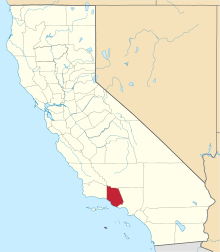 | |
| CDPs | ||
| Unincorporated communities | ||
| Footnotes | ‡This populated place also has portions in an adjacent county or counties | |