Old Wythe Historic District
|
Old Wythe Historic District | |
 | |
  | |
| Location | Roughly bounded by Hanover St., Pear Ave., Hampton Ave, & Kecoughtan Rd., Hampton, Virginia |
|---|---|
| Coordinates | 37°00′13″N 76°22′40″W / 37.00361°N 76.37778°WCoordinates: 37°00′13″N 76°22′40″W / 37.00361°N 76.37778°W |
| Area | 565 acres (229 ha) |
| Built | 1891 |
| Architect | Multiple |
| Architectural style |
Greek Revival, Queen Anne, Colonial Revival, Tudor Revival, Mission/Spanish Revival |
| NRHP reference # | 12000905[1] |
| VLR # | 114-5186 |
| Significant dates | |
| Added to NRHP | October 31, 2012 |
| Designated VLR | September 18, 2008[2] |
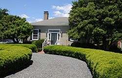
Old Wythe Historic District is a national historic district located at Hampton, Virginia. The district encompasses 2,076 contributing buildings, 1 contributing site, and 1 contributing structure in a primarily residential area of Hampton. The residences include notable examples of the Greek Revival, Queen Anne, Colonial Revival, Tudor Revival, and Mission Revival styles. The district first developed in the 1880s, and is composed generally of six primary subdivisions with the last platted in the 1930s. The earliest building is the John Simpson House (1849).[3]
It was listed on the National Register of Historic Places in 2012.[1]
References
- 1 2 "National Register of Historic Places Listings". Weekly List of Actions Taken on Properties: 10/29/12 through 11/02/12. National Park Service. 2012-11-09.
- ↑ "Virginia Landmarks Register". Virginia Department of Historic Resources. Retrieved 19 March 2013.
- ↑ Jill Dowling; Tom Bodor; Amy Bolasky; Lyle Torp & Robert J. Taylor Jr. (2012). "National Register of Historic Places Inventory/Nomination: Old Wythe Historic District" (PDF). Virginia Department of Historic Resources. and Accompanying four photos and Accompanying map


This article is issued from
Wikipedia.
The text is licensed under Creative Commons - Attribution - Sharealike.
Additional terms may apply for the media files.