Old Town Historic District (Harrisonburg, Virginia)
|
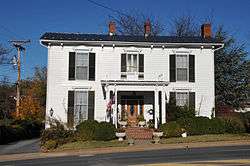
Old Town Historic District | |
 | |
  | |
| Location | Roughly bounded by Cantrell Ave., Ott, Water & S. Main Sts., Harrisonburg, Virginia |
|---|---|
| Coordinates | 38°26′44.3″N 78°51′58.8″W / 38.445639°N 78.866333°WCoordinates: 38°26′44.3″N 78°51′58.8″W / 38.445639°N 78.866333°W |
| Area | 98.5 acres (39.9 ha) |
| Built | 1850 |
| Architect | Collins, Samuel; et al. |
| Architectural style | Late Victorian, Late 19th And 20th Century Revivals |
| NRHP reference # | 08000026[1] |
| VLR # | 115-5001 |
| Significant dates | |
| Added to NRHP | February 14, 2008 |
| Designated VLR | September 5, 2007[2] |
The Old Town Historic District is an area located near downtown Harrisonburg, Virginia, that has been added to the National Register of Historic Places. It was added in March 2008. The area covers from northeast of James Madison University up to the area of Woodbine Cemetery.[3] A map is provided below.
Plans for the area include upscale and ethnic restaurants in restored historic structures, shops, antiques and boutiques, museums, art galleries, and a cultural arts district.
References
- ↑ National Park Service (2009-03-13). "National Register Information System". National Register of Historic Places. National Park Service.
- ↑ "Virginia Landmarks Register". Virginia Department of Historic Resources. Retrieved 19 March 2013.
- ↑ "Woodbine Cemetery - Rockingham County, Virginia - Harrisonburg Rockingham Historical Society". www.heritagecenter.com. Retrieved 30 September 2018.


This article is issued from
Wikipedia.
The text is licensed under Creative Commons - Attribution - Sharealike.
Additional terms may apply for the media files.