Oaklette Historic District
|
Oaklette Historic District | |
 Seneca Avenue | |
  | |
| Location | Roughly bounded by Indian River Rd., Oaklette, Webster, St. Lawrence, & Seneca Sts., Chesapeake, Virginia |
|---|---|
| Coordinates | 36°49′41″N 76°14′14″W / 36.82806°N 76.23722°WCoordinates: 36°49′41″N 76°14′14″W / 36.82806°N 76.23722°W |
| Area | 75 acres (30 ha) |
| Built | 1883 |
| Architect | Willoughby W. Colonna |
| Architectural style | Colonial Revival, Bungalow/craftsman, et al. |
| NRHP reference # | 03000563[1] |
| VLR # | 131-5073 |
| Significant dates | |
| Added to NRHP | June 23, 2003 |
| Designated VLR | March 19, 2003[2] |
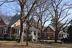
Oaklette Historic District is a national historic district located at Chesapeake, Virginia. The district encompasses 30 contributing buildings and 1 contributing object in an early-20th century planned streetcar suburb of Norfolk, Virginia. It is a primarily residential district that developed starting about World War I. The dwellings include representative examples of the Colonial Revival and Bungalow styles. Notable buildings include the Savage House (1915-1919), Pascal Paxson House (1901), George Wesley Jones House (1925), Samuel Paxson House (1906), Colonna Estate Caretaker's House (1925), and the Baker House (1910).[3]
It was listed on the National Register of Historic Places in 2003.[1]
References
- 1 2 National Park Service (2010-07-09). "National Register Information System". National Register of Historic Places. National Park Service.
- ↑ "Virginia Landmarks Register". Virginia Department of Historic Resources. Retrieved 5 June 2013.
- ↑ Kimble A. David (December 2002). "National Register of Historic Places Inventory/Nomination: Oaklette Historic District" (PDF). Virginia Department of Historic Resources. and Accompanying four photos and Accompanying map


This article is issued from
Wikipedia.
The text is licensed under Creative Commons - Attribution - Sharealike.
Additional terms may apply for the media files.