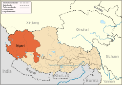
Ngari Prefecture
| Ngari Prefecture 阿里地区 མངའ་རིས་ས་ཁུལ། | |
|---|---|
| Prefecture | |
 | |
 prefecture (orange) in Tibet (light-orange) | |
| Country | People's Republic of China |
| Region | Tibet |
| Prefecture seat | Gar County (Shiquanhe) |
| Area | |
| • Total | 304,683 km2 (117,639 sq mi) |
| Population | |
| • Total | 95,465 |
| • Density | 0.31/km2 (0.81/sq mi) |
| Time zone | UTC+8 (China Standard) |
| ISO 3166 code | CN-XJ-25 |
| Website | Ngari(Ali) Prefecture Government |
Ngari Prefecture (Tibetan: མངའ་རིས་ས་ཁུལ་, Wylie: mnga' ris sa khul ; simplified Chinese: 阿里地区; traditional Chinese: 阿里地區; pinyin: Ālǐ Dìqū) is a prefecture of China's Tibet Autonomous Region. Its capital is Gar County. Its administrative centre is the town of Burang Town. The largest settlement is Shiquanhe. Ngari Prefecture includes part of the Aksai Chin area, a disputed region claimed by India but over which China exercises administrative control. The paved Xinjiang-Tibet Highway (新藏公路) passes through this area. There are well-known prehistoric petroglyphs near the far western town of Rutog.
The town of Ngari lies 4,500 metres (14,800 ft) above sea level in northwest Tibet some 1,600 kilometres (990 mi) west of the capital, Lhasa. Ngari Gunsa Airport began operations on July 1, 2010, becoming the fourth civil airport on the "Roof of the World" (shortening the trip to Lhasa to one-and-a-half hours from three or four days by car). The other airports in Tibet are Lhasa Gonggar Airport in Lhasa, Qamdo Bamda Airport in Chamdo and Nyingchi Mainling Airport.[1]
Ngari was once the heart of the ancient kingdom of Guge. Later Ngari, along with Ü and Tsang, composed Ü-Tsang, one of the traditional provinces of Tibet, the others being Amdo and Kham.
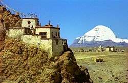
Ngari is best known for Mount Kailash, also called Sumeru, and Lake Manasarovar. Mount Kailash is 6,714 m (22,028 ft) above sea level and is the main peak of the Transhimalaya (also called the Kailash Range or Gangdisê Mountains). The holy mountain and lake are associated with a number of religions: Buddhism, Hinduism, and Bon, among others, attracting numerous domestic and international religious pilgrims and tourists. Surrounding Mount Kailash are four ancient and famous monasteries: Zhabura, Chiu Gompa, Zheri and Zhozhub. Manasarovar lies 4,588 m (15,052 ft) above sea level, covers an area of 412 km2 (159 sq mi) and reaches a maximum depth of 70 m (230 ft).
Subdivisions
Ali Prefecture is subdivided into seven county-level divisions: seven counties.
| Map | ||||||||
|---|---|---|---|---|---|---|---|---|
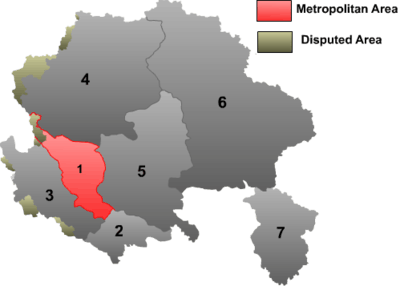 | ||||||||
| # | Name | Hanzi | Hanyu Pinyin | Tibetan | Wylie | Population (2010 Census) | Area (km²) | Density (/km²) |
| 1 | Gar County | 噶尔县 | Gá'ěr Xiàn | སྒར་རྫོང་ | sgar rdzong | 16,901 | 13,179 | 1.28 |
| 2 | Burang County | 普兰县 | Pǔlán Xiàn | སྤུ་ཧྲེང་རྫོང་ | spu hreng rdzong | 9,657 | 24,602 | 0.39 |
| 3 | Zanda County | 札达县 | Zhádá Xiàn | རྩ་མདའ་རྫོང་ | rtsa mda' rdzong | 6,883 | 18,083 | 0.38 |
| 4 | Rutog County | 日土县 | Rìtǔ Xiàn | རུ་ཐོག་རྫོང་ | ru thog rdzong | 9,738 | 77,096 | 0.12 |
| 5 | Gê'gyai County | 革吉县 | Géjí Xiàn | དགེ་རྒྱས་རྫོང་ | dge rgyas rdzong | 15,483 | 46,117 | 0.33 |
| 6 | Gêrzê County | 改则县 | Gǎizé Xiàn | སྒེར་རྩེ་རྫོང་ | sger rtse rdzong | 22,177 | 135,025 | 0.16 |
| 7 | Coqên County | 措勤县 | Cuòqín Xiàn | མཚོ་ཆེན་རྫོང་ | mtsho chen rdzong | 14,626 | 22,980 | 0.63 |
Geography
| Climate data for Shiquanhe, Gar County, Ngari Prefecture, elevation 4,255 m (13,960 ft) | |||||||||||||
|---|---|---|---|---|---|---|---|---|---|---|---|---|---|
| Month | Jan | Feb | Mar | Apr | May | Jun | Jul | Aug | Sep | Oct | Nov | Dec | Year |
| Record high °C (°F) | 6.4 (43.5) |
9.5 (49.1) |
13.4 (56.1) |
15.7 (60.3) |
20.5 (68.9) |
25.2 (77.4) |
32.1 (89.8) |
26.4 (79.5) |
23.7 (74.7) |
16.7 (62.1) |
12.7 (54.9) |
7.1 (44.8) |
32.1 (89.8) |
| Average high °C (°F) | −4.1 (24.6) |
−2.0 (28.4) |
2.3 (36.1) |
7.4 (45.3) |
12.6 (54.7) |
18.1 (64.6) |
21.5 (70.7) |
20.5 (68.9) |
16.3 (61.3) |
8.2 (46.8) |
2.9 (37.2) |
−1.6 (29.1) |
8.5 (47.3) |
| Daily mean °C (°F) | −12.0 (10.4) |
−9.2 (15.4) |
−4.8 (23.4) |
0.1 (32.2) |
5.1 (41.2) |
10.7 (51.3) |
14.4 (57.9) |
13.8 (56.8) |
9.3 (48.7) |
0.5 (32.9) |
−5.7 (21.7) |
−10.1 (13.8) |
1 (33.8) |
| Average low °C (°F) | −19.7 (−3.5) |
−16.9 (1.6) |
−12.6 (9.3) |
−7.9 (17.8) |
−2.7 (27.1) |
3.1 (37.6) |
7.7 (45.9) |
7.5 (45.5) |
2.0 (35.6) |
−8.0 (17.6) |
−14.8 (5.4) |
−18.2 (−0.8) |
−6.7 (19.9) |
| Record low °C (°F) | −36.6 (−33.9) |
−30.2 (−22.4) |
−25.3 (−13.5) |
−17.9 (−0.2) |
−11.2 (11.8) |
−6.6 (20.1) |
−0.6 (30.9) |
−0.4 (31.3) |
−10.0 (14) |
−17.0 (1.4) |
−23.5 (−10.3) |
−32.9 (−27.2) |
−36.6 (−33.9) |
| Average precipitation mm (inches) | 1.6 (0.063) |
1.2 (0.047) |
1.4 (0.055) |
1.3 (0.051) |
2.9 (0.114) |
3.7 (0.146) |
21.4 (0.843) |
23.8 (0.937) |
5.7 (0.224) |
2.0 (0.079) |
0.3 (0.012) |
1.1 (0.043) |
66.4 (2.614) |
| Source: China Meteorological Administration,[2] | |||||||||||||
See also
Footnotes
- ↑ Tibet's fourth civil airport opens
- ↑ 中国地面国际交换站气候标准值月值数据集(1981-2010年) (in Chinese). China Meteorological Administration. Retrieved January 1, 2011.
Further reading
- Bellezza, John Vincent: Zhang Zhung. Foundations of Civilization in Tibet. A Historical and Ethnoarchaeological Study of the Monuments, Rock Art, Texts, and Oral Tradition of the Ancient Tibetan Upland. Denkschriften der phil.-hist. Klasse 368. Beitraege zur Kultur- und Geistesgeschichte Asiens 61, Verlag der Oesterreichischen Akademie der Wissenschaften, Wien 2008.
- Zeisler, Bettina. (2010). "East of the Moon and West of the Sun? Approaches to a Land with Many Names, North of Ancient India and South of Khotan." In: The Tibet Journal, Special issue. Autumn 2009 vol XXXIV n. 3-Summer 2010 vol XXXV n. 2. "The Earth Ox Papers", edited by Roberto Vitali, pp. 371–463.
External links
| County-level divisions | | |
|---|---|---|
| Towns and villages | ||
| Geography | ||
| Landmarks | ||
Coordinates: 32°30′00″N 80°06′05″E / 32.50000°N 80.10139°E