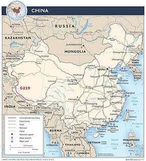
China National Highway 219
| |
|---|---|
| 219国道 | |
 | |
| Route information | |
| Length | 1,296 mi[1] (2,086 km) |
| Existed | 1957 – present |
| Major junctions | |
| north-west end | Yecheng (Karghilik) |
| south-east end | Lhatse |
| Highway system | |
|
China National Highways | |
.svg.png)
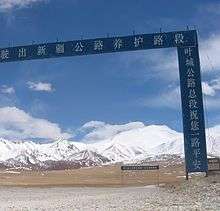
China National Highway 219 (G219) runs along the southwestern border of the People's Republic of China, from Yecheng (Karghilik) in the Xinjiang Uyghur Autonomous Region to Lhatse in the Tibet Autonomous Region. It is 1,296 miles (2,086 kilometers) in length.[1] Construction of this road was started in 1951.[2] It was completed in 1957.[3] The road passes through disputed area of Aksai Chin, an area administered by the People's Republic of China but also claimed by India, and its construction was one of the triggers for the Sino-Indian War of 1962. Originally made of gravel, it was fully paved with asphalt in 2013.[4]
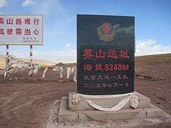
As one of the highest motorable roads in the world, the breathtaking scenery of Rutok county also ranks as some of the most inhospitable terrain on the planet. Domar township—a town of concrete blocks and nomad tents—is one of the bleakest and most remote outposts of the People's Liberation Army at the edge of the Aksai Chin. Near the town of Mazar many trekkers turn off for both the Karakorum range and K2 base camp. Approaching the Xinjiang border, past the final Tibetan settlement of Tserang Daban is a dangerous 5,050-meter-high pass. Tibetan nomads in the area herd both yaks and two-humped camels. Descending through the western Kunlun Shan, the road crosses additional passes of 4,000 and 3,000 meters, and the final pass offers brilliant views of the Taklamakan Desert far below before descending into the Karakax River basin.
The road passes near Mount Kailash and Lake Manasarovar and Pangong Tso.
Route and distance
| Route and distance | ||||||||||||||||||
|
See also
References
- 1 2 G219 in Google Maps
- ↑ MemCons of Final sessions with the Chinese, White House, 1971-08-12
- ↑ 50th anniversary of Xinjiang-Tibet Highway marked Archived 2010-05-28 at the Wayback Machine., China Tibet Information Center, 2007-11-01
- ↑ Li, Ying (24 September 2014). "A road in the sky". Global Times. Retrieved 30 September 2018.
- Dorje, Gyurme. (2009). Footprint Tibet Handbook. (4th Ed.) Footprint Handbooks, Bath, England. ISBN 978-1-906098-32-2.
External links
- Xinjiang-Tibet Highway (Yecheng-Burang)
- The Highway 219 from Yecheng over Western Tibet to Kathmandu Description and profile of the route.
- From Kashgar to Lhassa Photos along highway 219 (text in French).
- Some photos along the Highway 219
- A detailed description of a bicycle ride along highway 219 with lots of photos
| Radial | |
|---|---|
| North-south | |
| East-west | |
| Extended plan in 2013 under construction/renovation |
|
| Major Routes (Abolished and absorbed into NTHS) |
|
| Note | China National Highway 112 runs around Beijing |