Newry
| Newry | |
|---|---|
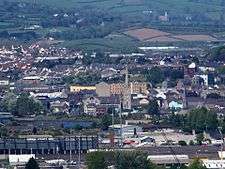
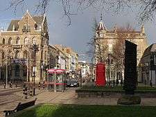
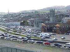
.jpg) Top: Newry skyline, Middle: The Buttercrane, The Quays, Newry Town Hall, Bottom: Drumalane Mill, Newry Cathedral | |
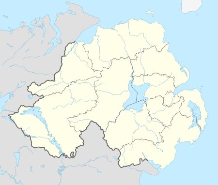 Newry Newry shown within Northern Ireland | |
| Population | 26,967 (2011)[4] |
| Irish grid reference | J085265 |
| District | |
| County | |
| Country | Northern Ireland |
| Sovereign state | United Kingdom |
| Post town | NEWRY |
| Postcode district | BT34, BT35 |
| Dialling code | 028 |
| Police | Northern Ireland |
| Fire | Northern Ireland |
| Ambulance | Northern Ireland |
| EU Parliament | Northern Ireland |
| UK Parliament | |
| Website | www.newrymournedown.org |
Newry (/ˈnjʊəri/;[5] from Irish: An Iúraigh[6]) is a city in Northern Ireland, divided by the Clanrye river in counties Armagh and Down, 34 miles (55 km) from Belfast and 67 miles (108 km) from Dublin. It had a population of 26,967 in 2011.[7][8][9]
Newry was founded in 1144 alongside a Cistercian monastery, although there are references to earlier settlements in the area, and is one of Ireland's oldest towns. The city is an entry to the "Gap of the North", close to the border with the Republic of Ireland. It grew as a market town and a garrison and became a port in 1742 when it was linked to Lough Neagh by the first summit-level canal built in Ireland or Great Britain. In 2002, as part of Queen Elizabeth's Golden Jubilee celebrations, Newry was granted city status along with Lisburn.[10]
Name
The name Newry is an anglicization of An Iúraigh, an oblique form of An Iúrach, which means "the grove of yew trees".[11]
The modern Irish name for Newry is An tIúr (pronounced [ən̠ʲ tʲuːɾˠ]), which means "the yew tree". An tIúr is an shortening of Iúr Cinn Trá, "yew tree at the head of the strand", which was formerly the most common Irish name for Newry.[11] This relates to an apocryphal story that Saint Patrick planted a yew tree there in the 5th century.
The Irish name Cathair an Iúir (City of Newry) appears on some bilingual signs around the city.[12]
History

There is strong evidence of continual human habitation in the area from early times, where it is seen during the Bronze Age that Newry had a factory-type community who were producing in abundance very detailed jewellery for garments. Three of these Newry Clasps can be found in the Ulster Museum, and a massive arm clasp from the same period was also found in Newry.[13] In recent times the survey for the new bypass revealed a number of standing stones on a central area down the Omeath Road. These, like many other finds, such as that of an ancient cave at the top of the Dublin Road area, have seemingly been noted and forgotten about. It is estimated that as many as 130 ancient sites were discovered at the top of the Camlough Road. Among them three Neolithic homesteads were discovered. At the time all were noted, and left to be destroyed by the new road. Standing stones were also seen on at least one of these sites, but they stand no more. In AD 820, the Danes made one of their "earliest irruptions at Newry abbey, from whence they proceeded to Armagh, taking it by storm, and plundering and desolating the country around."[14]
In AD 835 the Danes again made a sudden incursion into Newry, with a large body of Danes landing at Inbher-Chin-Tra-gha, or Newry, and raided the area before attacking Armagh, where they set fire to the churches and university, plundering gold and other items from them and killing an estimated one thousand people in the city and surrounding area. The Victorian era historian James Henthorn Todd goes into further detail in his 1867 Volume, (Chronicles and memories of England and Ireland in the Middle Ages) recording that the abbey was attacked in AD 824. A small medieval town was on the site to the north and south of the abbey, which was rebuilt in 1142 (Keating G) by King O Carroll of the Oriel at the request of Saint Malachi (Ibid). The landing stage of the abbey was situated close to the western bank of the Newry River in what is now Kilmorey Street. From these early times it was the main pier and port of the town; it remained as such until the construction of the new canal took place. The abbey was later converted to a collegiate church in 1543, before being surrendered to the Crown in 1548. The abbey is seen to be giving its earnings to the Crown almost 200 years before this date. It is described as being one of the richest and largest in Ireland. The Vikings attacked the Abbey many times, slaughtering its occupants. The town was granted its first charter between 1157 by High King of Ireland Muirchertach Mac Lochlainn.[15]
In 1162 the monastery was attacked and raided by Irish clans. De Courcy's lordship ensured a safe spell for the abbey after he had built several castles in and around Newry, These were typical Norman affairs, of motte-and-bailey construction.
In 1539 an English mercenary, Nicholas Bagenal, fled to Ireland after murdering a man in Leek, Staffordshire, apparently with the aid of his two brothers.[16] After some time in the employment of the O Neill he reached a high status, was granted a pardon in 1543, and became Marshal of the army. During his early years in the Louth area he lived at Carlingford where his son Henry was born. Lord Bingham is seen sending Oriel labourers to Newry in 1546 at which time Bagenal is seen restoring the castle of Newry which belonged to Hugh O Neill being first built by John De Courcy in 1186 (De Arcy McGee See also Lewis 1815) Not long after this the Marshal, in 1552, secured a 21-year lease on the Newry property, which was confiscated from the Cistercians. The castle was then razed to the ground by Shane O Neill, who banished Bagenal from Newry in 1566.
The nearby convent was also part of the Abbey, and is mentioned in the Bagenal patent. A small medieval church can be found in its grounds. The abbey site is mentioned in the rent rolls of 1575, and said to consist of a church, a steeple, a cemetery, a chapterhouse, dormitory and hall, two orchards and one garden, containing one acre, within the precincts of a monastic college.
During the 1689 Raid on Newry Williamite forces under Toby Purcell repulsed an attack by the Jacobites under the Marquis de Boisseleau. At the period of the Battle of the Boyne, the Duke of Berwick set fire to the parts of the town which he had restructured to defend it, see Berwicks Journal, Schomberg sent troops in during the early hours of the mornings when seeing the flames, they successfully extinguished them. While it is believed that King William may have stayed at a Newry Castle, the story is a far-fetched one. King William took a portable wooden bedroom with him on this campaign, which he called his "coach". (see The Impartial History by Rev Story) The King refused to sleep in castles or houses, preferring to be amongst his men.
One of the main castles of Newry at this date was an ancient abbey building which stood at Mill Street corner, in the northwest end of the abbey complex. Its remains were finally demolished in 1965. The other abbey buildings were once used by Bagenal (30-odd years), as pigsties and stables, according to the O Neill website. These buildings lay neglected when King William passed through the town. For over 100 years they were nothing more than great massive stores or sheds in the background and not considered as part of the town. Isaac Corry demolished some of them in the early 1800s. Those he did not demolish were turned into homesteads or warehouses. Included were the 140 feet of the great church that was constructed in 1142. He demolished its altar and completely dug up the ancient graveyard beside the church, removing ancient bones by the cartload to St Mary's at Chapel Street. While there was deep mourning from the Catholics of the town at these actions, no one complained because of Corry's status. The graveyard is currently a carpark for Lidl and the great church is now a museum: Bagenal Castle.
By 1881 the population of Newry had reached 15,590.[7] Newry Urban District Council was unusual in that during the period from the 1920s to the 1960s it was one of only a handful of councils in Northern Ireland which had a majority of councillors from the Catholic/Nationalist community. (The others were Strabane UDC and a handful of rural district councils.) The reason, according to Michael Farrell, was that this community formed such a large majority in the town, around 80% of the population, making it impossible to gerrymander. Also an oddity was that for a time it was controlled by the Irish Labour Party, after the left wing of the Northern Ireland Labour Party defected to them in the 1940s.[17]
The Troubles
Newry saw several violent incidents during the conflict known as the Troubles. These went on into the late 1990s and even in 2010 – such as bomb scares and car bombs.
See also: The Troubles in Killeen, for information on incidents at the border and customs post at Newry on the border with the Republic of Ireland and close to Newry. In 2003, the hilltop watch towers were taken down. The Army withdrew from the area on 25 June 2007 when they closed their final base at Bessbrook.[18][19] As there are no garrisons in the area the British Army has had no official presence in Newry or South Armagh since the end of Operation Banner.
Geography
Newry lies in the most south-eastern part of both Ulster and Northern Ireland. About half of the city (the west) lies in County Armagh and the other half (the east) in County Down. The Clanrye River, which runs through the city, forms the historic border between County Armagh and County Down.
The city sits in a valley, between the Mourne Mountains to the east and the Ring of Gullion to the south-west, both of which are designated Areas of Outstanding Natural Beauty. The Cooley Mountains lie to the south east. The Clanrye River runs through the centre of town, parallel to the Newry Canal. The city also lies at the northernmost end of Carlingford Lough, where the canal enters the sea at Victoria Locks.
Townlands
Newry is within the civil parishes of Newry and Middle Killeavy. The parishes have long been divided into townlands, the names of which mainly come from the Irish language. The following is a list of townlands in Newry's urban area,[20] alongside their likely etymologies:[6][21]
| Townland | Origin (Irish unless stated) | Translation |
|---|---|---|
| Altnaveigh Aghnaveigh (alternate local name) |
Alt na bhFiach Achadh na bhFiach |
glen of the ravens field of the ravens |
| Ballinlare | Baile na Ladhaire | townland of the fork/gap |
| Carnagat | Carn na gCat | cairn of the cats |
| Carnbane | Carn Bán | white cairn |
| Derry Beg | Doire Beag | little oak wood |
| Drumalane | An Droim Leathan | broad ridge |
| Lisdrumgullion | Lios Droim gCuilinn | fort of the holly ridge |
| Lisdrumliska | Lios Druim Loiscthe | fort of the burnt ridge |
| Townland | Origin (Irish unless stated) | Translation |
|---|---|---|
| Ballynacraig | Baile na gCreag | townland of the crags |
| Ballinaire | Baile an Iubhair | settlement of the yew tree |
| Carneyhough | Cárn Uí hEochadha[22] | O'Haughey's Carn |
| Cloghanramer | Clochán Ramhar | thick stone structure/causeway |
| Commons | an English name that first appeared in 1810[23] | |
| Creeve | Craobh | tree/bush |
| Damolly | probably Damh Maoile | house of the round hill |
| Drumcashellone | Droim Caisil Eoghain | the ridge of Eoghan's cashel |
| Greenan | Grianán | eminent or sunny place |
Demography
Although officially a city, Newry is classified as a large town by Northern Ireland Statistics and Research Agency (NISRA) (i.e. with the population between 18,000 and 75,000 people).
2011 Census
On Census day (27 March 2011) there were 26,967 people living in Newry, accounting for 1.49% of the NI total.[24] Of these:
- 21.46% were aged under 16 years and 12.74% were aged 65 and over;
- 51.02% of the usually resident population were female and 48.98% were male;
- 88.27% belong to or were brought up in the Catholic religion and 8.47% belong to or were brought up in a 'Protestant and Other Christian (including Christian related)' religion;
- 56.12% had an Irish national identity, 27.27% had a Northern Irish national identity and 12.65% indicated that they had a British national identity (respondents could indicate more than one national identity);
- 35 years was the average (median) age of the population;
- 19.60% had some knowledge of Irish (Gaelic) and 2.37% had some knowledge of Ulster-Scots.
Climate
As with the rest of Northern Ireland, Newry has a temperate climate, with a narrow range of temperatures, regular windy conditions, and rainfall throughout the year.
| Climate data for Newry, United Kingdom (1981–2010 normals) | |||||||||||||
|---|---|---|---|---|---|---|---|---|---|---|---|---|---|
| Month | Jan | Feb | Mar | Apr | May | Jun | Jul | Aug | Sep | Oct | Nov | Dec | Year |
| Average high °C (°F) | 6.8 (44.2) |
7.1 (44.8) |
9.2 (48.6) |
11.5 (52.7) |
14.5 (58.1) |
17.0 (62.6) |
18.7 (65.7) |
18.3 (64.9) |
15.9 (60.6) |
12.4 (54.3) |
9.1 (48.4) |
6.9 (44.4) |
12.3 (54.1) |
| Average low °C (°F) | 1.7 (35.1) |
1.8 (35.2) |
2.8 (37) |
4.2 (39.6) |
6.5 (43.7) |
9.3 (48.7) |
11.2 (52.2) |
11.1 (52) |
9.2 (48.6) |
6.7 (44.1) |
4.0 (39.2) |
2.2 (36) |
5.9 (42.6) |
| Average precipitation mm (inches) | 108.9 (4.287) |
74.9 (2.949) |
84.5 (3.327) |
74.5 (2.933) |
68.3 (2.689) |
64.6 (2.543) |
74.7 (2.941) |
82.7 (3.256) |
77.5 (3.051) |
104.8 (4.126) |
100.0 (3.937) |
103.2 (4.063) |
1,018.7 (40.106) |
| Source: Met Office (UK)[25] | |||||||||||||
Economy
Newry has a reputation as one of the best provincial shopping-towns in Northern Ireland, with the Buttercrane Centre and The Quays Newry attracting large numbers of shoppers from as far away as Cork.[26]
In 2006 Newry topped the league of house prices increases across the whole United Kingdom over the last decade, as prices in the city had increased by 371% since 1996.[27] The city itself has become markedly more prosperous in recent years. Unemployment has reduced from over 26% in 1991 to scarcely 2% in 2008.[28]
Since the inception of the global financial crisis of 2008-2009, shoppers from the Republic of Ireland have increasingly been crossing the border to Newry to buy cheaper goods due to the difference in currency. This owes to a combination of factors: the harsh budget in the Republic of Ireland in October 2008; the growing strength of the euro against the pound sterling and VAT reductions in the United Kingdom, compared with increases in the Republic of Ireland. This remarkable increase in cross-border trade has become so widespread that it has lent its name to a general phenomenon known as the Newry effect. In December 2008, The New York Times described Newry as "the hottest shopping spot within the European Union's open borders, a place where consumers armed with euros enjoy a currency discount averaging 30 percent or more".[29]
However the increased flow of trade has led to resultant tailbacks, sometimes several miles long (many kilometres), on approach roads from the south. This has created huge traffic and parking problems in Newry and the surrounding area. It has also become a political issue, with some politicians in the Republic of Ireland claiming that such cross-border shopping is "unpatriotic".[30]
Transport
- The Newry Canal opened in 1742. It is the oldest Canal in Ireland or Britain and when functioning as an inland transport waterway, it ran for 18 miles to Lough Neagh. In 1777, Newry was ranked the fourth largest port in Ireland. Some surviving 18th and 19th century warehouses still line the canal, and now many houses, shops and restaurants.
- In 1885 an electric tramway was opened between Newry and Bessbrook.
- MacNeill's Egyptian Arch is a railway bridge located near Newry. It was selected for the design of the British One Pound coin to represent Northern Ireland for 2006.
- Newry is served by an Ulsterbus bus station, located in the city centre. The bus station is situation along The Mall, suspended over the Clanrye River. Services in Newry include local, regional and cross-border transport with a free shuttle bus service to the local train station and services to local schools around Newry and Mourne.
- Newry railway station, just off the Camlough road, offers cross border services on the Dublin-Belfast line as well as some regional services around areas of County Armagh and County Down. Transport to other places generally requires a change in either Belfast or Dublin. Planning permission for the construction of a new station to the east of the current station, was granted in May 2006 and the new station opened on 7 September 2009 by Northern Ireland Railways.
- Newry is on the main M1/A1 route from Dublin to Belfast. Originally the route passed through the town centre, but in the 60s was bypassed by the Abbey Link. This remained the sole relief road until 1996[31] when it was superseded by a single carriageway bypass round the western side of the town. By 2008 the road on either side of the town had been upgraded to motorway/high quality dual carriageway standard (southwards from Cloghogue) and low quality dual carriageway (northwards from Beechill). In July 2010 a new high quality dual carriageway with motorway characteristics was opened to bridge the gap, thus connecting Dublin with Belfast by motorway/dual carriageway for the first time. The opening of this section of Road meant that motorists could travel from Clogh in County Antrim to Midleton, County Cork by dual carriageway/motorway. Part of this older bypass is still in use between the Camlough Road (A25) and the Belfast Road (A1). Newry suffers from very heavy traffic with shoppers coming from across the border.[32] Newry is connected with Warrenpoint by a lower quality dual carriageway, some seven miles to the south.
Administration
The headquarters of Newry, Mourne and Down District Council are based in Newry. The area has a majority nationalist population. The Newry, Mourne and Down District Council election, 2014 resulted in 3 Sinn Fein, 2 SDLP and 1 Independent councillors being elected in the Newry electoral area.
Notable buildings
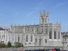
Saint Patrick's Church was built in 1578 on the instructions of Nicholas Bagenal, who was granted the monastery lands by Edward VI, and is considered to be the first Protestant church in Ireland. The Cathedral of SS Patrick and Colman on Hill Street was built in 1829 at a cost of £8,000. The structure, which consists of local granite, was designed and built by Thomas Duff, arguably Newry's greatest architect to date.[33]
Incidentally, Thomas Duff also was the architect for the Cathedral in Dundalk, a town just over the border in County Louth, and it is said that he mixed up the plans for both cathedrals and sent Dundalk Cathedral to the builders in Newry, and Newry Cathedral to the builders in Dundalk.
Town Hall is notable for being built over the River Clanrye which is the historic boundary between the counties of Armagh and Down. The city also boasts a museum and an arts centre and, in recent years, has seen a number of art galleries being opened.
The impressive Craigmore Viaduct lies just north of the city on the Northern Ireland Railways Belfast-Dublin mainline. The bridge was designed by Sir John MacNeill with construction beginning in 1849. The bridge was formally opened in 1852. The viaduct consists of eighteen arches the highest being 126 feet, the highest viaduct in Ireland. It is around a quarter of a mile long and was constructed from local granite. The Enterprise Train link from Belfast to Dublin crosses the bridge.
The Newry Reporter every week highlights a historic building in Newry and the surrounding area, giving a brief outline of its history.
Hospitals
Churches
Roman Catholic
- Cathedral of Saints Patrick and Colman, Hill Street (1825–29)
- Church of the Sacred Heart and St Catherine, Dominic Street (1875)
- St Brigid's, Derrybeg (1970)
- St Mary's, Chapel Street (1789; formerly Newry Cathedral)
- Church of the Sacred Heart, Cloghogue (1916)
- Church of the Assumption, Drumalane (1954)
- Church of the Immaculate Conception (Parochial House), 44 Barrack Street
Protestant Churches
- St Patrick's Church of Ireland (1578) -- possibly the first Protestant church ever built in Ireland. It was destroyed by fire and rebuilt.[34]
- St Mary's Church of Ireland (1819)[34]
- Camus Presbyterian Church, The Manse, 5 Nancy's Lane
- Methodist Church, Railway Street
- Newry Baptist Church, Downshire Place
- First Presbyterian Church (Non-Subscribing), John Mitchel Place
- Riverside Reformed Presbyterian Church, Basin Walk
- The Salvation Army, Trevor Hill
- Metropolitan Church, Edward Street
Other
- Kingdom Hall of Jehovah's Witnesses, Belfast Road
Notable people
Arts and Media
- Christine Bleakley, Daybreak host, was born in Daisy Hill Hospital, Newry.
- Margaret Clarke, (1884-1961), portrait painter, was born in Newry.
- Thomas Duff, (1792–1848), architect. Renowned for designing the Cathedral of St. Patrick and St. Colman.
- Julia Glover, 18th and 19th century stage actress.[35]
- Frank Hall, (1921-1995), broadcaster and satirist with RTÉ.
- Seán Hillen, artist, was born and grew up in Newry, and made a large body of photomontage artworks related to the Troubles, many of which are based on his own photographs taken in and around Newry. They include a series satirically titled "LondoNewry, a Mythical Town".
- Valene Kane, actress best known for playing Lyra Erso in Rogue One.
- Michael Legge, actor, best known for his recurring role in the Channel 4 series Shameless and for his part in the film Angela's Ashes.[36]
- Actor siblings John and Susan Lynch, were both born in Newry.
- Tomm Moore, twice Oscar nominated filmmaker, was born in Newry before moving to Kilkenny at an early age.[37]
- Gerard Murphy, actor, was born in Newry, and was a prominent member of the Newpoint Players theatre group.[38]
Groups
- The 4 of Us – local rock band
- Luv Bug, local pop group who represented Ireland at the 1986 Eurovision Song Contest
- Crubeen, a 1970s local folk band
Religion
- John Dunlop, prominent Presbyterian churchman, was born in Newry in 1939.
- John Magee, Roman Catholic Bishop of Cloyne and former private secretary to three popes, Paul VI, John Paul I and John Paul II.
Academia and Science
- Joseph Barcroft, respiratory physiologist, (1872–1947)
- W. J. Barre (1830–1867), architect who designed the Ulster Hall in Belfast in the late 1850s.[39]
Politics and Diplomacy
- Sir Trevor Corry (1724–1780) British diplomat and Baron of Poland, born in Newry[40]
- Sir William Hill Irvine GCMG (6 July 1858 – 20 August 1943), the 21st Premier of Victoria was born in Newry.
- Alfred Ludlam (1810 – 8 November 1877) A leading New Zealand politician and philanthropist
- John Martin (8 September 1812 – 29 March 1875) an Irish nationalist was born in Newry.
- John Mitchel, a 19th-century Irish patriot who inspired the Young Ireland Movement, and apologist for slavery and the Confederate States of America, is buried in the Old Meeting House cemetery in the town.[41]
- William Irvine, Australian Colonial Politician, Premier of Victoria, born Newry 1858. Nephew of John Mitchel.
- Pádraig Ó Cuinn (1898 – August 1974), prominent leader in the Irish Republican Army during the Irish War of Independence was born and later served as a general practitioner in Newry.
- Charles Russell, Baron Russell of Killowen, (1832–1900), Lord Chief Justice of England and Wales, was born in Newry on 10 November 1832.
Sport
- Michael Cusack (1847-1906) - founder of the GAA, taught at St Colman's College, Newry[42]
- Pat Jennings, a former goalkeeper and most capped player for Northern Ireland, was born in the town and played for Newry Town F.C.
- Willie Maley (25 April 1868 – 2 April 1958), the first manager of Celtic was born in Newry.
- Danny McAlinden, former British and Commonwealth champion heavyweight boxer, was born in Newry.
- Ryan McGivern, defender capped for Northern Ireland.
- Peter McParland, a former footballer, who scored for Northern Ireland in 1958 FIFA World Cup, was born in Newry.
- Seán O'Neill, Gaelic footballer
- Ronan Rafferty, golfer, was born in Newry.
Sport
Football
Until 2012, Newry City F.C. played at the Showgrounds before being liquidated. A phoenix club named Newry City AFC was formed to play in amateur leagues in 2013
The local amateur league, the Carnbane League was established in 1968. As of 2011 the teams competing in these leagues at senior level are:
- Newry Celtic
- Rockview United
- Bessbrook United
- Windmill Stars
- Ballybot United
- Woodside
- Finn Harps
- Killeavey United
- Cleary Celtic
- Killowen Celtic
- Kilkeel Athletic
- Damolly United
- Crieve Rovers
First Division
- Grasshoppers
- Whitecross AFC
- North End Strollers
- Midway United
- Drumcashlone
- Millburn United
- Parkview
- Ashgrove Rovers
- Rostrevor Rovers
- Bohemians
- Villa Rovers
- Clanrye Athletic
- Newry Juventus
- Cartwheel United
Gaelic Athletic Association
The Down GAA team has its home ground at Páirc Esler in the city. Local clubs are Newry Bosco GFC, Newry Shamrocks GAC, John Mitchel GFC and Ballyholland GFC, all in Down GAA, and Thomas Davis GFC, Corrinshego and Killeavy St Moninna's GAC, both in Armagh GAA.
Rugby Union
Newry RFC (also known as Newry Rugby Club, Newry RFU or Newry) is an Irish amateur rugby union club, founded in 1925. The club is a member of the Irish Rugby Football Union's Ulster branch. The club currently fields three senior teams and several junior teams ranging from under-12 to under-18 and a women's team for the first time in 2010–2011 season. The club's home ground is known as Telford Park. The team currently has two playing fields located at this ground along with the clubhouse on the outskirts of Newry.
Hockey
Newry Olympic Hockey Club is located at the north of the city; the men's first XI currently play in the ONE1918 Senior 1 league.
Education
Primary Schools
- Ballyholland Primary School
- Bunscoil an Iúir
- Cloughoge Primary School
- Killean Primary School
- Mullaglass Primary School
- St Clare's Convent Primary School
- St. Colman's Abbey Christian Brothers' Primary School
- St Colman's Primary School, Saval
- St Joseph's Convent Primary School
- St Malachy's Primary School
- St. Patrick's Primary School, Newry|St Patrick's Primary School
- Windsor Hill Primary School
- St Ronan's Primary School
Post-Primary Schools
- Abbey Christian Brothers Grammar School
- Newry High School
- Our Lady's Grammar School
- Sacred Heart Grammar School
- St Colman's College
- St. John's Primary School
- St Joseph's Boys' High School
- St. Mary's High School
- St. Paul's High School, Bessbrook
Further Education
See also
References
- ↑ 2010 annual report in Ulster-Scots North/South Ministerial Council.
- ↑ 2002 annual report in Ulster-Scots North/South Ministerial Council.
- ↑ Guide to Inch Abbey in Ulster-Scots Archived 25 October 2013 at the Wayback Machine. Department of the Environment.
- ↑ "Usual Resident Population: KS101NI – Newry". Northern Ireland Neighbourhood Information Service (NINIS). Northern Ireland Statistics and Research.
- ↑ Dictionary.com. "Dictionary.com – Newry". Retrieved 26 January 2012.
- 1 2 "Newry and Mourne (C. Dunbar)" (PDF). Retrieved 26 September 2011.
Newry (town), County Armagh/County Down. The modern Irish name of Newry is An tIúr 'the yew tree' being an abbreviation of Iúr Cinn Trá 'yew tree at the head of the strand'. The anglicised form comes from An Iúraigh an oblique form of An Iúrach 'the grove of yew trees' (PNI vol. I).
- 1 2 http://www.planningni.gov.uk/index/policy/dev_plans/devplans_az/bnm_2015/bnm_district_proposals/bnm_proposals_newry/bnm_newry_city/bnm_newrycity_background.htm
- ↑ http://www.newrychamber.com/areainfo/index.asp
- ↑ NI Planning Service: District Proposal For Newry City Archived 27 November 2007 at the Wayback Machine., newrychamber.com; accessed 9 December 2016.
- ↑ BBC report
- 1 2 Placenames NI: Newry
- ↑ Welcome sign in Newry, Northern Ireland, in English and Irish
- ↑ H.E Kilbride-Jones Craftmanship in Bronze, free to read in Google books
- ↑ Anthony Mamions Ancient and Modern History of the Maritime Ports of Ireland (1855)
- ↑ See Flanagan, M.: Irish Royal Charters – Texts and Contexts (2005) Oxford University Press: London.
- ↑ http://www.newryjournal.co.uk/2006/06/20/nicholas-bagenal-1509-1590/ Newry Journal
- ↑ Michael Farrell Northern Ireland: The Orange State
- ↑ BBC News http://news.bbc.co.uk/mobile/bbc_news/northern_ireland/623/62355/story6235514.shtml?=. Retrieved 7 April 2010. Missing or empty
|title=(help) - ↑ Soldiers depart Bessbrook Mill for the final time
- ↑ Ordnance Survey Ireland: Online map viewer (choose "historic" to see townland boundaries)
- ↑ The Northern Ireland Place-Name Project
- ↑ Placenames NI – The Northern Ireland Place-Name Project. "Townland of Carneyhough".
- ↑ Placenames NI – The Northern Ireland Place-Name Project. "Townland of Commons". Retrieved 27 September 2011.
- ↑ "Census 2011 Population Statistics for Coleraine Settlement". Northern Ireland Statistics and Research Agency (NISRA). 2011. Retrieved 5 June 2018.
- ↑ "Newry Climate". UK Met Office. Retrieved 28 May 2013.
- ↑ "David McKittrick: The great nappy rush (no, not rash)". The Independent. London. 1 January 2009. Retrieved 7 April 2010.
- ↑ Halifax House Price Survey
- ↑ Article by Frances McDonnell, Belfast Briefing, page 21, Irish Times, 9 December 2008, quoting Dr Gerard O'Hare
- ↑ Quinn, Eamon (18 December 2008). "A Northern Ireland Town Is a Shoppers' Paradise". The New York Times. Retrieved 7 April 2010.
- ↑ Irish Times, 9 December 2008, op cit
- ↑ http://www.u.tv/News/New-%C2%A3150m-Newry-bypass-opens/7afdae52-9da9-4d54-9ff1-c21f4fe58474
- ↑ "Northern Ireland Assembly debates, 9 March 2009, 2:45 pm". mySociety. Retrieved 1 December 2009.
- ↑ "Newry Cathedral". Newry and Mourne District Council. Archived from the original on 13 October 2006. Retrieved 25 June 2008.
- 1 2 Newry and Mourne District Council. "Newry City, The town's history". Archived from the original on 16 September 2007. Retrieved 16 January 2008.
- ↑ Taylor & Francis Group; Cathy Hartley; Susan Leckey (2003). A Historical Dictionary of British Women. Routledge. p. 186. ISBN 1-85743-228-2.
- ↑ Michael Legge on IMDb
- ↑ Tomm Moore on IMDb
- ↑ Gerard Murphy on IMDb
- ↑ http://www.belfastcity.gov.uk/ulsterhall/faqs.asp
- ↑ Journal of the Association for the Preservation of Memorials of the Dead in Ireland (1898), p. 255
- ↑ Culture Northern Ireland
- ↑ "Down to celebrate the Michael Cusack Connection". Retrieved 1 December 2017.
External links
| Wikivoyage has a travel guide for Newry. |
- Newry Times
- Destination Newry and Mourne
- Newry at Curlie (based on DMOZ)
- Newry and Mourne District Council
- ActivNewry.com – Newry's business, events, and community directory
- Newry City.com
- Newry.ie – All things Newry with Events, Photograph Archive from the 80's and latest News
- Newry Memoirs
| Large |  | |
|---|---|---|
| Medium | ||
| Small | ||
Italics denote settlements that are classed as towns but also have city status | ||
Geography of County Armagh | ||
|---|---|---|
| Cities and towns | 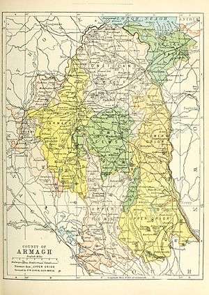 | |
| Villages and townlands |
| |
| Landforms | ||
| Baronies | ||
| ||
