St Davids
St Davids
| |
|---|---|
| City | |
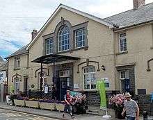
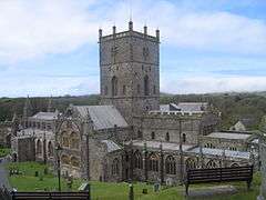 St Davids Cathedral | |
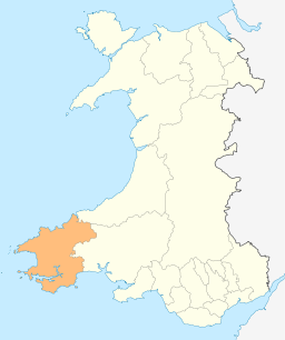
 St Davids St Davids shown within Pembrokeshire | |
| Area |
17.93 sq mi (46.4 km2) (community) 0.23 sq mi (0.60 km2) (urban area) |
| Population | 1,841 [1] (2011) |
| • Density | 103/sq mi (40/km2) |
| OS grid reference | SM755255 |
| Community |
|
| Principal area | |
| Ceremonial county | |
| Country | Wales |
| Sovereign state | United Kingdom |
| Post town | HAVERFORDWEST |
| Postcode district | SA62 |
| Dialling code | 01437 |
| Police | Dyfed-Powys |
| Fire | Mid and West Wales |
| Ambulance | Welsh |
| EU Parliament | Wales |
| UK Parliament | |
| Welsh Assembly | |
St Davids or St David's[2][3] (Welsh: Tyddewi, [tɨː ˈðɛwi], lit. "David's house") is a city[4] and a community (named St Davids and the Cathedral Close)[5] with a cathedral in Pembrokeshire, Wales, lying on the River Alun. It is the final resting place of Saint David, Wales's patron saint, and named after him. St Davids is the United Kingdom's smallest city in terms of population (1,841 in 2011)[6] and urban area; however, the smallest city by formal definition of local authority boundary area is the City of London.
In the 16th century, St Davids was given city status. The status does not apply automatically on the basis of any particular criteria, although in England and Wales it was traditionally given to towns with diocesan cathedrals. This association between having a cathedral and being called a city was established in the early 1540s when King Henry VIII founded dioceses. City status was lost in 1886 but, at the request of Queen Elizabeth II, restored in 1994.

History
Tradition states that David was born to Saint Non at what is now St Non's, just to the south of the city, in about AD 500. It is said that he was baptised at Porthclais, now the city's port, and was brought up by his mother at Llanon. St David may also have been educated at Ty Gwyn, Whitesands, by St Paulinus.
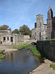
In the 6th century, David founded a monastery and church at Glyn Rhosyn (Rose Vale) on the banks of the River Alun. The area was originally known in the Welsh language as Mynyw and to the Romans as Meneva or Menevia. The monastic brotherhood that David founded was very strict — besides praying and celebrating masses, they cultivated the land and carried out many crafts, including beekeeping, in order to feed themselves and the many pilgrims and travellers who needed lodgings. They also fed and clothed the poor and needy.[7] The settlement that grew up around the monastery was called Tyddewi meaning "David's house". In 519 the archbishopric of Caerleon in the county of Monmouth was transferred to Mynyw, which was renamed "St Davids" in honour of the archbishop and saint by whom the transfer was accomplished.[8] The original cathedral built on the site was often plundered by the Vikings and was finally burnt and destroyed in 1087. The present cathedral was built by the Normans and contained many relics, including the remains of St David. It was visited by many pilgrims, many of whom were nobles and kings, including William the Conqueror in 1077, Henry II in 1171, and Edward I and Queen Eleanor in 1284.[8] Pope Calixtus II decreed that two pilgrimages to St Davids were equivalent to one to Rome ("Roma semel quantum dat bis Menevia tantum"). Because of this, a vast income was raised from visiting pilgrims in the Middle Ages.[9] Pilgrimages later fell out of favour due to practices such as the selling of indulgences, and the income from them faded away. By the 19th century, the city of St Davids was isolated and neglected and was described in the Penny Cyclopaedia,[8]
At present its appearance is that of a poor village, the houses, excepting those of the clergy, being in a ruinous state. The locality is lonely, and the neighbouring district wild and unimproved; but it is still an interesting place as the seat of a large episcopal see, with a fine cathedral and the remains of other magnificent religious edifices.
Since then, better transport and the advent of tourism have helped the city prosper again. Next to the cathedral, the 13th-century Bishop's Palace is a ruin maintained by Cadw and open to visitors. The city was once a marcher borough, within which lay the hundred of Dewisland. In 1603, the antiquarian George Owen described it as one of five Pembrokeshire boroughs overseen by a portreeve.[10]
In addition to the cathedral, notable features of the city include the 14th-century Tower Gate, the Celtic Old Cross and a number of art galleries. St Davids is also a base for walking and water sports. It has several hotels, a pharmacy, shops and galleries, a youth hostel and a number of pubs.
Geography
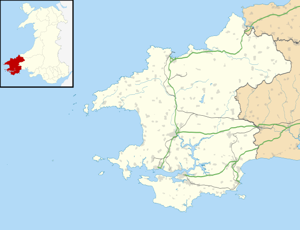
The community council area sits at the southern end of the Irish Sea on a peninsula, between Cardigan Bay, St George's Channel and St Brides Bay. It covers not just the mainland area, but also several islands off the coast, of which Ramsey Island is the largest and the only one inhabited, separated by the Ramsey Sound. The most westerly mainland point of Wales is at Pen Dal-aderyn. To the north lie Whitesands Bay and St Davids Head, which are locally notable landscape features. The mainland contains much area used for farming, but contains very small scattered residences and several campsites. St Davids Lifeboat Station, at St Justinian, has saved an estimated 360 people since the first lifeboat was located there in 1869; four lifeboatmen have died while saving others.[11] The Irish Sea includes a large number of offshore rocks and islands and is notorious for strong tides.[12] The entire coastline around St Davids forms part of the Pembrokeshire Coast National Park. Saint Non's Well overlooks the Pembrokeshire Coast Path and St Brides Bay. St David's Airfield, although named after the city when opened in 1943, is in the neighbouring community of Solva. The highest point is Carn Llidi at 181 metres (594 ft)
Several isolated hamlets are located throughout the community:
- Berea
- Caerfarchell
- Carnhedryn
- Fachelich/Vachelich
- Llandruidion
- Rhodiad-y-brenin
- Treleddyd-fawr
- Trelerw
- Tretio
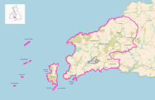
Several islands and islets, lie within a few miles from the coast. These are administratively within St Davids:
- Ramsey Island also known as Ynys Dewi (the largest)
- Carreg Yr Esgob
- Carreg Fran
- Ynys Eilun
- Ynys Bery
The islands below are part of the Bishop And Clerks grouping, and were included in 1987:[13]
- Carreg Rhoson
- Carreg Rhoson East Island
- Carreg-trai
- Cribog
- Daufraich
- Llechau-isaf
- Llechau-uchaf
- Maen Daufraich
- Maen Rhoson
- Moelyn
- North Bishop
- South Bishop also known as Em-sger, is the furthest away from Pen Dal-aderyn at 4 miles.
City status
In the 16th century a town was recognised as a city by the English Crown if it had a diocesan cathedral within its limits, but this link was abolished in 1888[14], and amid borough reorganisation,[15] St Davids lost the right to call itself a city. In 1991 St Davids town council proposed that a case for city status, which the residents had long considered it to have anyway, should be promoted in connection with the 40th anniversary of the coronation of Queen Elizabeth II, and in 1992 the Home Office agreed to refer the matter to Buckingham Palace. In 1994, at the request of the Queen, St Davids was again granted city status along with the Northern Irish town of Armagh, "In recognition of their important Christian heritage and their status as cities in the last century".[14] The letters patent conferring city status were formally presented by the Queen in a ceremony at St Davids Cathedral on 1 June 1995.[16]
The award of city status is typically granted to a local authority,[17] whose administrative area is then considered to be the formal borders of the city. By this definition, the whole community area of St Davids and the Cathedral Close, including the settlement of St Davids, its surrounding rural area, and islands off the coast, is considered to be the limits of the city. St Davids contains the lowest population of all the cities of the UK, and has the smallest urban area, at 0.23 sq mi (0.60 km2). However, with the formal city area defined by its community council extent of 17.93 sq mi (46.4 km2), this sizeable expanse including offshore islands does mean that several other UK cities are physically smaller, with the City of London being the smallest at 1.12 sq mi (2.9 km2). In Wales, St Davids is third smallest behind the community areas of St Asaph at 2.49 sq mi (6.4 km2), and Bangor with 2.79 sq mi (7.2 km2).
Governance
St Davids was a borough from 1115[18] until 1886, when this was abolished by the Municipal Corporations Act 1883, its corporation deemed to be long extinct. This, in turn, appears to have caused the loss of city status, as there was no corporate body available to petition for a renewal of its charter.[15] The borough lay across two parishes, and by the time of the creation of registration districts in 1837 these were:[19][20]
- Cathedral Close of St. David's – the close surrounding the cathedral and associated church buildings;
- St Davids – the rest of the city and rural areas.
These were split from the church into civil parishes during 1866, converted to Welsh community administrative areas in 1974, and merged in 1987[5] to form the present day St Davids and the Cathedral Close.
St Davids City Council is the community council body, and is composed of twelve councillors.[21] The City Council employs one City Clerk and one Financial Officer.[21] The currently elected presiding officer is The Rt Wp The Mayor of St Davids Cllr John George.[21] Sir David Jones of Fachelich was recently presented with the key to the city.
The parishes were part of the Haverfordwest rural sanitary district, then Haverfordwest rural district from 1894 until 1974 when they changed to communities and placed into Preseli district.[22] Preseli was abolished in 1996 under further local government reform, and the city presently comes under Pembrokeshire County Council for all principal government services.
The electoral ward of St Davids elects a county councillor to Pembrokeshire County Council.
Culture and sport
The city hosted the National Eisteddfod in 2002. The Archbishop-designate of Canterbury, Dr Rowan Williams, was inducted into the Gorsedd of Bards, a historic order of Druids.[23]
The St Davids Penknife Club is a group of people dedicated to voluntary fund raising for local groups and charities.[24]
St Davids has a rugby union club, St Davids RFC, which competes in the SWALEC League Six West.[25]
Whitesands Bay, about two miles west of St Davids, is a popular watersports resort. It has been described as the best surfing beach in Pembrokeshire and one of the best tourist beaches in the world.[26]
Education
Ysgol Dewi Sant (St David's School) is the local secondary school, with pupils in Years 7–13 (i.e. aged from 11 to 18).[27] Ysgol Bro Dewi (Dewisland School) is a Voluntary Controlled Primary School, with pupils from Reception to Year 6.
Notable people
- Asser, mentor of King Alfred the Great, and writer of his biography, was a monk at St Davids before being called into Alfred's service.
- William Barlow, expert on magnetism and Anglican cleric, was born in St Davids some time during the tenure of his father, also William Barlow, as bishop (1536–48).
- Henry Hicks (1837–1899), eminent surgeon and geologist, was born at St Davids and practised there from 1862 until 1871.
- Thomas Tomkins (1572–1656), eminent musician and composer, was born in St Davids.
Twin towns
St Davids is twinned with: [28]


See also
References
- ↑ Office for National Statistics 2011 census – St David's and the Cathedral Close C
- ↑ Parish Headcounts for Pembrokeshire (based on 2001 Census) at Office for National Statistics. Retrieved 2011-08-01
- ↑ As specified in New Oxford Dictionary for Writers and Editors OUP 2005. The name is often spelt without its possessive apostrophe, including by the St Davids City Council
- ↑ "GENUKI: St David's". Retrieved 7 March 2016.
- 1 2 "The Preseli (Communities) Order 1987". www.legislation.gov.uk.
Communities 6. In the District as altered....
(3) the... existing communities of ...Cathedral Close of St. David's, ...St. Davids, ...shall be abolished;
(4) ...new communities to be known as ...St. Davids and the Cathedral Close, ...shall be constituted; - ↑ "Office for National Statistics 2011 – census – St David's and the Cathedral Close C".
- ↑ Jones,, Rhys James (28 February 1994). "Saint David and Saint David's Day". Retrieved 21 June 2012.
- 1 2 3 Anon (1837). "David's, St". The Penny Cyclopædia of the Society for the Diffusion of Useful Knowledge. London: Charles Knight and Co. 7–8: 317. Retrieved 21 June 2012.
- ↑ St David's day, Pembrokeshire Archived 2011-09-27 at the Wayback Machine. at History.UK.com, 16 February 2003. Retrieved on 1 August 2011
- ↑ Owen, George, The Description of Penbrokshire by George Owen of Henllys Lord of Kemes, Henry Owen (Ed), London, 1892
- ↑ St Davids Lifeboat Station: Introduction Archived 2011-08-11 at the Wayback Machine. at Royal National Lifeboat Institution (RNLI). Accessed on 1 August 2011
- ↑ St Davids Lifeboat Station Archived 2011-08-22 at the Wayback Machine. at Royal National Lifeboat Institution (RNLI). Accessed on 1 August 2011
- ↑ "The Preseli (Communities) Order 1987". www.legislation.gov.uk.
Communities
6.
(6) the Bishops and Clerks shall be included in the new community of St. Davids and the Cathedral Close - 1 2 Beckett, J. V. (2005). City status in the British Isles, 1830–2002. Ashgate Publishing, Ltd. p. 22. Retrieved 31 January 2012.
- 1 2 "Agenda Item No: 5 COMMITTEE REGENERATION AND COMMUNITY OVERVIEW AND SCRUTINY COMMITTEE DATE 4 MARCH 2003 TITLE OF REPORT ROCHESTER CITY STATUS RESPONSIBLE OFFICER Mark Bowen, Assistant Director, Legal and Contract Services" (PDF). democracy.medway.gov.uk. Medway Council.
St. David’s in Wales lost City Status through local government re-organisation at the end of the 19th century.
- ↑ Alderson, Alf (3 March 2001). "The small city with the big kicks". The Guardian. Guardian News and Media Limited. Retrieved 21 June 2012.
- ↑ "Corby City Bid" (PDF). www.corby.gov.uk. Corby Borough Council.
Applications may only be made by an elected local authority – normally, in respect of the entire local authority area.
- ↑ "PROPOSED DEVELOPMENT SITE NUN STREET, ST DAVIDS, PEMBROKESHIRE: HISTORIC ENVIRONMENT APPRAISAL" (PDF). www.haystonplanning.co.uk.
Nothing is known of any civilian settlement prior to 1115 when St Davids was established as a borough, receiving its first charter from King Henry I.
- ↑ https://www.ukbmd.org.uk/reg/places/regindex2-3.pdf
- ↑ https://www.ukbmd.org.uk/reg/districts/haverfordwest.html
- 1 2 3 http://www.stdavids.gov.uk/council-information/
- ↑ "Haverfordwest RSD through time | Census tables with data for the Sanitary District". www.visionofbritain.org.uk.
- ↑ St Davids and St Davids Cathedral, Pembrokeshire at Wales in Style. Accessed on 1 August 2011
- ↑ "St Davids Penknife Club". Retrieved 2011-07-03.
- ↑ SWALEC League Six West at Welsh Rugby Union
- ↑ "Pembrokeshire County Council". 19 September 2017.
- ↑ "The Curriculum". Ysgol Dewi Sant website. 2014. Retrieved 15 January 2014.
- ↑ "St Davids City Council – Twin towns". Retrieved 20 September 2014.
Further reading
- O'Malley, Brian Brendan, comp. (1985) A Pilgrim's Manual: St Davids. Marlborough: Paulinus Press ISBN 0-907740-13-8
External links
| Wikimedia Commons has media related to St David's. |
| Wikivoyage has a travel guide for St Davids. |
- St Davids City Council
- St Davids at www.visitpembrokeshire.com (official council tourism website)
- St Davids at Curlie (based on DMOZ)