City of Winchester
| City of Winchester | |
|---|---|
| Non-metropolitan district, Borough, City | |
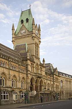 Winchester Guildhall | |
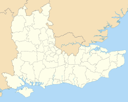
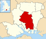 Winchester shown within Hampshire | |
| Sovereign state | United Kingdom |
| Constituent country | England |
| Region | South East England |
| Non-metropolitan county | Hampshire |
| Status | Non-metropolitan district, Borough, City |
| Admin HQ | Winchester |
| Incorporated | 1 April 1974 |
| Government | |
| • Type | Non-metropolitan district council |
| • Body | Winchester City Council |
| • Leadership | Leader & Cabinet (Conservative) |
| • MPs | Steve Brine |
| Area | |
| • Total | 255.20 sq mi (660.97 km2) |
| Area rank | 59th (of 326) |
| Population (mid-2017 est.) | |
| • Total | 123,900 |
| • Rank | 185th (of 326) |
| • Density | 490/sq mi (190/km2) |
| • Ethnicity | 97.8% White |
| Time zone | UTC0 (GMT) |
| • Summer (DST) | UTC+1 (BST) |
| ONS code |
24UP (ONS) E07000094 (GSS) |
| OS grid reference | SU485295 |
| Website |
www |
.jpg)
The City of Winchester (/ˈwɪntʃɪstər/) is a local government district in Hampshire, England, with city status.
It covers an area of central Hampshire including the ancient settlement of the city of Winchester itself, and neighbouring towns and villages. For a full list of these, see the "Settlements and parishes" section below.
The current city boundaries were set on 1 April 1974 when the City of Winchester merged with the former Droxford Rural District and part of the former Winchester Rural District council areas.
Elections
Elections to the council are held in three out of every four years, with one third of the seats on the council being elected at each election. From 1995 to the 2004 election the Liberal Democrats had a majority on the council, but after 2 years when no party held a majority the 2006 election saw the Conservative party gain control.[1] The elections on 6 May 2010 saw the Liberal Democrats re take control of the council, however the council soon switched to NOC a year later in 2011. In 2012, the Conservative Party made their only Council gain of the entire English local elections and won a majority in Winchester once again.[2] Subsequently, two Conservative councillors defected to the Liberal Democrat group, placing the council under No Overall Control.[3] Following local elections on 7 May 2015, the Conservatives re-gained majority control of the council. [4]
The council is currently led by a Conservative administration. The make up of the council as of May 2015 is:[5]
- Conservatives - 33
- Liberal Democrats - 22
- Labour - 2
| Election | Member[4] | Ward | |
|---|---|---|---|
| 2014 | David McLean | Bishops Waltham | |
| 2015 | Tom Ruffell | Bishops Waltham | |
| 2012 | Steve Miller | Bishops Waltham | |
| 2012 | Neil Cutler | Boarhunt and Southwick | |
| 2015 | Amber Thacker | Cheriton and Bishops Sutton | |
| 2015 | Susan Cook | Colden Common and Twyford | |
| 2014 | Richard Izard | Colden Common and Twyford | |
| 2012 | Peter Kent Mason | Colden Common and Twyford | |
| 2012 | Mike Southgate | Compton and Otterbourne | |
| 2015 | Jan Warwick | Compton and Otterbourne | |
| 2014 | Kirk Phillips | Denmead | |
| 2012 | Michael Read | Denmead | |
| 2015 | Patricia Stallard | Denmead | |
| 2014 | Caroline Dibden | Droxford Soberton and Hambledon | |
| 2015 | Kim Gottlieb | Itchen Valley | |
| 2012 | Robert Johnston | Kings Worthy | |
| 2014 | Jane Rutter | Kings Worthy | |
| 2012 | James Byrnes | Littleton and Harestock | |
| 2015 | Paul Twelftree | Littleton and Harestock | |
| 2014 | Patrick Fancett | Oliver's Battery and Badger Farm | |
| 2012 | Brian Laming | Oliver's Battery and Badger Farm | |
| 2015 | Robert Humby | Owlesbury and Curdridge | |
| 2014 | Laurence Ruffell | Owlesbury and Curdridge | |
| 2012 | Linda Gemell | Shedfield | |
| 2014 | Roger Huxstep | Shedfield | |
| 2014 | Caroline Horrill | Sparsholt | |
| 2015 | Eileen Berry | St Barnabas | |
| 2014 | Helen Osborne | St Barnabas | |
| 2012 | Anne Weir | St Barnabas | |
| 2014 | Dominic Hiscock | St Bartholomew | |
| 2012 | Jim/James Maynard | St Bartholomew | |
| 2015 | Rosemary Burns | St Bartholomew | |
| 2012 | Janet Berry | St John & All Saints | |
| 2014 | Clive Gosling | St John & All Saints | |
| 2015 | Jonathan Scowen | St John & All Saints | |
| 2014 | Rose Prowse | St Luke | |
| 2011 | Jamie Scott | St Luke | |
| 2012 | Derek Green | St Luke | |
| 2011 | Fiona Mather | St Michael | |
| 2012 | Robert Sanders | St Michael | |
| 2014 | Ian Tait | St Michael | |
| 2015 | Liz Hutchison | St Paul | |
| 2014 | Lucille Thompson | St Paul | |
| 2012 | Martin Tod | St Paul | |
| 2015 | Frank Pearson | Swanmore and Newtown | |
| 2014 | Victoria Weston | Swanmore and Newtown | |
| 2012 | Simon Cook | The Alresfords | |
| 2015 | Ernest Jeffs | The Alresfords | |
| 2014 | Margot Power | The Alresfords | |
| 2015 | Norma Bodtger | Upper Meon Valley | |
| 2012 | Vivian Achwal | Whiteley | |
| 2015 | Sam Newman-McKie | Whiteley | |
| 2015 | Angela Clear | Wickham | |
| 2012 | Therese Evans | Wickham | |
| 2015 | Malcolm Wright | Wonston and Micheldever | |
| 2012 | Barry Lipscomb | Wonston and Micheldever | |
| 2014 | Stephen Godfrey | Wonston and Micheldever | |
Winchester in elections every four years elects three representatives to Hampshire County Council, currently:
| Election | Member[6] | Ward | |
|---|---|---|---|
| 2013 | Fiona Mather | Winchester Eastgate | |
| 2013 | Phil Bailey | Winchester Downlands | |
| 2013 | Martin Tod | Winchester Westgate | |
Demographics
A Legatum Prosperity Index published by the Legatum Institute in October 2016 showed the City of Winchester as the third most prosperous council area in the United Kingdom, after the Borough of Waverley and Mole Valley.[7]
Settlements and parishes
Settlements in the district include:
- Abbotts Barton, Abbots Worthy, Avington
- Badger Farm, Beauworth, Bighton, Bishops Sutton, Bishops Waltham, Boarhunt, Bramdean, Brockwood Park
- Cheriton, Chilcomb, Colden Common, Compton and Shawford, Corhampton, Crawley, Curdridge
- Denmead, Droxford, Durley
- Easton, Exton
- Hambledon, Headbourne Worthy, Hinton Ampner, Hursley
- Itchen Abbas, Itchen Stoke, Itchen Valley
- Kilmeston, Kings Worthy
- Littleton and Harestock
- Martyr Worthy, Meonstoke, Micheldever, Morestead
- New Alresford, Northington
- Old Alresford, Olivers Battery, Otterbourne, Ovington, Owslebury
- Shedfield, Soberton, Southwick, South Wonston, Sparsholt, Stoke Charity, Sutton Scotney, Swanmore
- Tichborne, Twyford
- Upham
- Warnford, West Meon, Whiteley (part), Wickham, Widley, Winchester, Winnall, Wonston
References
- ↑ "Local elections: Winchester". BBC News Online. Retrieved 2010-02-04.
- ↑ "City Councillors". Winchester City Council. Archived from the original on 18 February 2010. Retrieved 29 May 2010.
- ↑ . Winchester Liberal Democrats. 2014 http://www.winld.org.uk/2014/01/22/two-conservative-councillors-join-the-liberal-democrats/. Retrieved 2014-01-22. Missing or empty
|title=(help) - 1 2 . Winchester City Council. 2015 http://www.winchester.gov.uk/elections/election-results/district/district-election-results-may-2015/. Retrieved 2015-08-05. Missing or empty
|title=(help) - ↑ . Winchester City Council. 2015 http://www.winchester.gov.uk/elections/election-results/district/district-election-results-may-2015/. Retrieved 2015-08-05. Missing or empty
|title=(help) - ↑ Hampshire County Councillors. Retrieved 2012-05-30
- ↑ Emily Chan, Jessica Duncan, It's wonderful in Waverley but hell in Hull! League table of most prosperous places to live show it's grim up north - but how does your town rate? in Daily Mail online dated 22 October 2016, accessed 22 October 2016