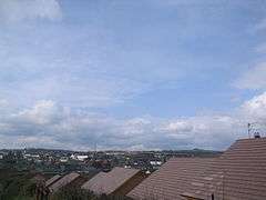
Banbridge
| Banbridge | |
|---|---|
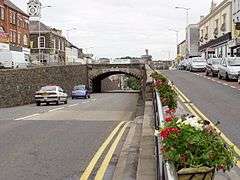 'The Cut' in Banbridge | |
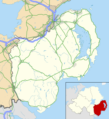 Banbridge Banbridge shown within County Down | |
| Population | 16,653 (2011 Census) |
| District | |
| County | |
| Country | Northern Ireland |
| Sovereign state | United Kingdom |
| Post town | BANBRIDGE |
| Postcode district | BT32 |
| Dialling code | 028 |
| Police | Northern Ireland |
| Fire | Northern Ireland |
| Ambulance | Northern Ireland |
| EU Parliament | Northern Ireland |
| UK Parliament | |
| NI Assembly | |
Banbridge (/bænˈbrɪdʒ/ ban-BRIJ)[2] is a town in County Down, Northern Ireland. It lies on the River Bann and the A1 road and is named after a bridge built over the River Bann in 1712. It is situated in the civil parish of Seapatrick and the historic barony of Iveagh Upper, Upper Half.[3] The town began as a coaching stop on the road from Belfast to Dublin and thrived from Irish linen manufacturing. The town is the headquarters for Banbridge District Council. It had a population of 16,653 people in the 2011 Census.[4]
The town's main street is very unusual, and rises to a steep hill before levelling out. In 1834 an underpass was built as horses with heavy loads would faint before reaching the top of the hill. It was built by William Dargan and is officially named 'Downshire Bridge', though it is often called "The Cut".
History
Banbridge, home to the "Star of the County Down", is a relatively young town, first entering recorded history around 1691 during the aftermath of the struggle between William III and James II. An Outlawry Court was set up in the town to deal with the followers of James.[5] The town grew up around the site where the main road from Belfast to Dublin crossed the River Bann over an Old Bridge which was situated where the present bridge now stands.
The town owes its success to flax and the linen industry, becoming the principal linen producing district in Ireland by 1772 with a total of 26 bleachgreens along the Bann. By 1820 the town was the centre of the 'Linen Homelands' and its prominence grew when it became a staging post on the mail coach route between Dublin and Belfast. A gift of £500 from the Marquis of Downshire around this time helped to alleviate some problems with the steepness of the road and paid for significant improvements.[6] This industry has now greatly diminished in prominence, but Banbridge still has three of the major producers in Ulster; Weavers, Thomas Ferguson & Co, and John England Irish Linen.
Banbridge has staged an annual busking competition and music festival called Buskfest since 2004. Performers often travel long distances to participate. The competition closes with an evening concert composed of performances by world-famous artists.
Recently, Banbridge has been twinned with Ruelle in France.
The Troubles
Banbridge had three major bombings during the Troubles. On 15 March 1982, a Provisional IRA bomb on Bridge Street killed a schoolboy and injured 36 people.[7][8] On 4 April 1991, another IRA bomb of 1,000 lb of explosives caused widespread damage and injured a police officer.[9] There was also a dissident republican bombing on 1 August 1998 after the signing of the Good Friday Agreement (see 1998 Banbridge bombing).
Townlands
Like the rest of Ireland, the Banbridge area has long been divided into townlands, whose names mostly come from the Irish language. Banbridge sprang up in a townland called Ballyvally. Over time, the surrounding townlands have been built upon and they have lent their names to many streets, roads and housing estates. The following is a list of townlands within Banbridge's urban area, alongside their likely etymologies:[10][11]
- Ballydown (from Baile an Dúin meaning "townland of the stronghold")
- Ballymoney (from Baile Muine meaning "townland of the thicket")
- Ballyvally (from Baile an Bhealaigh meaning "townland of the routeway")
- Drumnagally (from Dromainn Ó gCeallaigh meaning "O'Kelly's ridge")
- Edenderry (from Éadan Doire meaning "hill-brow of the oak-wood")
- Tullyear (from Tulaigh Eirre meaning "hillock of the boundary")
Demography
Banbridge is classified as a medium town (i.e. with population between 10,000 and 18,000 people) by the Northern Ireland Statistics and Research Agency (NISRA).[12]:11
2011 Census
On Census day (27 March 2011) there were 16,637 people living in Banbridge (6,693 households), accounting for 0.92% of the NI total.[13] Of these:
- 21.92% were aged under 16 years and 13.69% were aged 65 and over;
- 51.21% of the usually resident population were female and 48.79% were male;
- 59.17% belong to or were brought up in a 'Protestant and Other Christian (including Christian related)' religion and 34.38% belong to or were brought up in the Catholic religion;
- 61.59% indicated that they had a British national identity, 31.48% had a Northern Irish national identity and 15.39% had an Irish national identity (respondents could indicate more than one national identity);
- 37 years was the average (median) age of the population;
- 6.83% had some knowledge of Irish (Gaelic) and 6.35% had some knowledge of Ulster-Scots.
2001 Census
On Census day (29 April 2001), there were 14,744 people living in Banbridge. Of these:
- 24.4% were aged under 16 years and 16.1% were aged 60 and over
- 49.5% of the population were male and 50.5% were female
- 33.7% were from a Catholic background and 63.7% were from a Protestant background
- 3.3% of people aged 16–74 were unemployed.
Places of interest
- Near the town lie the ancient Lisnagade Fort, Legannany Dolmen, and the Loughbrickland Crannóg, constructed around the year 500 AD
- Thomas Ferguson & Co Ltd factory tours.
- The town is situated a short distance from the Brontë Homeland in Rathfriland- the church at which Patrick Brontë preached often hosts musical performances by well-known artists, e.g. Eddi Reader.
Notable people
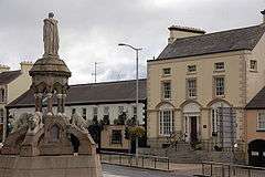
- Captain Francis Crozier, British naval officer and Arctic explorer, was born in Banbridge in 1796. A monument to him stands in the town square; four polar bears are carved on the base.
- F. E. McWilliam, surrealist sculptor.
- John Mitchel, Irish nationalist activist and political journalist.
- John Butler Yeats, artist and father of four artistic children. Among them were William Butler Yeats and Jack Butler Yeats.
- Robbie Dennison, former Wolverhampton Wanderers FC winger and Northern Ireland football international.
- Samuel Fryar, politician from the 1930s.
- Dermott Lennon world show jumping champion hails from Ballinaskeagh just outside Banbridge.
- Jonathan Tuffey, Northern Ireland No 2 goalkeeper, currently playing for Glenavon in the Irish League.
- Dame Anna Hassan, educator, school principal.
- Joseph M. Scriven, writer of the poem which became the hymn "What a Friend We Have in Jesus".
- Samantha Lewthwaite, terrorism suspect.[14]
- Cyril Scott, actor
- Arthur Cox, actor
Transport
Banbridge is on the A1 main road between Belfast and Newry. The nearest railway station is Scarva on Northern Ireland Railways' Belfast–Newry railway line, about 4 miles (6.4 km) west of Banbridge.
Banbridge had its own railway station from 1859 until 1956. The Banbridge, Newry, Dublin and Belfast Junction Railway opened Banbridge (BJR) railway station on 23 March 1859.[15][16] In contrast with its very long name, this was a short branch line between Banbridge and Scarva.[15][16] This was followed by the opening of the Banbridge, Lisburn and Belfast Junction Railway between Knockmore Junction and Banbridge on 13 July 1863,[16] which gave Banbridge a more direct link via Lisburn with Belfast Great Victoria Street. Banbridge (BJR) railway station was closed in favour of the new Banbridge (BLBR) railway station.
The Great Northern Railway took over both companies in 1877[17] and opened a branch line from Banbridge to Ballyroney in 1880.[16] In 1906 the GNR opened an extension from Ballyroney to Castlewellan, where it connected with a new Belfast and County Down Railway branch line to Newcastle, County Down.[16]
In 1953 the governments of Northern Ireland and the Irish Republic jointly nationalised the GNR as the GNR Board.[18] On 1 May 1955 the GNRB closed Banbridge's lines to Scarva and Castlewellan.[19] Banbridge (BLBR) railway station closed on 29 April 1956, when the GNRB closed the line from Knockmore Junction.[19]
Education
Primary
- Abercorn Primary School
- Ballydown Primary School
- Bridge Primary School(Integrated)
- Bronte Primary School
- Edenderry Primary School
- Milltown Cemetery Primary School
- St. Mary's Primary School (Catholic)
Post-primary
- Banbridge Academy (Grammar)
- Banbridge High School
- St Patrick's College (Catholic)
- New-Bridge Integrated College(Integrated)
Sport
- One of the Banbridge sporting highlights probably was the 1920 - Ireland v. Scotland International Hockey Match played at Banbridge.
- The Banbridge Hockey Club wins in 1985 as the second team from Ireland, after Cookstown HC in 1981, the EuroHockey Club Champions Trophy.
Current sports clubs include: Banbridge Bowling Club
- Banbridge Town F.C.
- Banbridge Hockey Club
- Banbridge Rugby Club
- Banbridge Rangers F.C.
- Banbridge A.F.C.
- Moneyslane F.C.
- Banbridge Ladies Hockey Club
- Banbridge Athletics Club
- Banbridge Cycling Club
- Banbridge Golf Club
- Clann na Banna G.A.A Club
- Banbridge Rangers Football Club
- Banbridge Weight Training Club
- Banbridge AFC
- Banbridge Amateur Swimming Club
- Banbridge Boxing Club
- Banbridge Netball Club
Pop culture
- "The Star of the County Down" is a well known song associated with Banbridge.
- In the film The Day After Tomorrow (2004), a fictitious Sky News broadcast shows a depiction of Banbridge in the midst of an apocalyptic blizzard.
- One of the Game of Thrones sets is in Linen Mills Studio, which was converted from a failed linen mill.
See also
| Wikimedia Commons has media related to Banbridge. |
References
- ↑ Daein Gairdens fur Wilelife Northern Ireland Department of the Environment.
- ↑ G.M. Miller, BBC Pronouncing Dictionary of British Names (Oxford UP, 1971), p. 10.
- ↑ "Banbridge". IreAtlas Townlands Database. Retrieved 15 April 2015.
- ↑ "Banbridge". Census 2011 Results. NI Statistics and Research Agency. Retrieved 30 April 2015.
- ↑ Young, Alex F. (2002). Old Banbridge. Catrine, Ayrshire: Stenlake Publishing. p. 3. ISBN 9781840332049.
- ↑ Young, Alex. Ibid. p. 3.
- ↑ https://www.upi.com/Archives/1982/03/16/An-IRA-bomb-blitz-killed-a-schoolboy-and-injured/2812385102800/
- ↑ http://cain.ulst.ac.uk/othelem/chron/ch82.htm
- ↑ https://www.apnews.com/9189213c377b88108543d0e97dc2e7f0
- ↑ "Placenames Database of Ireland". Retrieved 30 February 2010. Check date values in:
|accessdate=(help) - ↑ "Northern Ireland Placenames Project". Archived from the original on 1 October 2010. Retrieved 30 May 2010.
- ↑ "Statistical Classification and Delineation of Settlements" (PDF). NI Statistics and Research Agency (NISRA). February 2005. Table 3 / Band C - Large Town. Retrieved 26 September 2018.
- ↑ "Census 2011 Population Statistics for Coleraine Settlement". Northern Ireland Statistics and Research Agency (NISRA). 2011. Retrieved 5 June 2018.
- ↑ "White Widow Samantha Lewthwaite now world's most wanted woman" – via www.belfasttelegraph.co.uk.
- 1 2 Hajducki, 1974, map 8
- 1 2 3 4 5 Hajducki, 1974, map 9
- ↑ Hajducki 1974, p. xiii.
- ↑ Baker 1972, pp. 146, 147.
- 1 2 Baker 1972, p. 207.
Sources
- Baker, Michael H.C. (1972). Irish Railways since 1916. London: Ian Allan. ISBN 978-0-7110-0282-1.
- Hajducki, S. Maxwell (1974). A Railway Atlas of Ireland. Newton Abbott: David & Charles. ISBN 0-7153-5167-2.
External links
| Large |  | |
|---|---|---|
| Medium | ||
| Small | ||
Italics denote settlements that are classed as towns but also have city status | ||
