Antrim, County Antrim
| Antrim | |
|---|---|
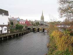 Church of Ireland and bridge over the Six Mile Water | |
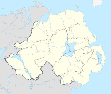 Antrim Antrim shown within Northern Ireland | |
| Population | 20,001 (2001 Census) |
| Irish grid reference | J1588 |
| • Belfast | 19 miles (31 km) |
| District | |
| County | |
| Country | Northern Ireland |
| Sovereign state | United Kingdom |
| Post town | ANTRIM |
| Postcode district | BT41 |
| Dialling code | 028 94 |
| Police | Northern Ireland |
| Fire | Northern Ireland |
| Ambulance | Northern Ireland |
| EU Parliament | Northern Ireland |
| UK Parliament | |
| NI Assembly | |
| Website | |
Antrim (from Irish: Aontroim, meaning "lone ridge", [ˈeːnˠt̪ˠɾˠɪmʲ])[4] is a town and civil parish in County Antrim in the northeast of Northern Ireland, on the banks of the Six Mile Water, half a mile northeast of Lough Neagh. It had a population of 20,001 people in the 2001 Census. It is the county town of County Antrim and was the administrative centre of Antrim Borough Council. It is 22 miles (35 km) northwest of Belfast by rail.
History
At the beginning of recorded history, the Antrim area was populated by Irish Gaels and was within the territory of Dál nAraidi. According to tradition, a monastery was founded near the present site of the round tower in 495, thirty years after the death of Saint Patrick, to take forward his ministry, with a small settlement growing up around it.[5]
By 1596, an English settlement had grown up around a ford across the Sixmilewater River and All Saints Parish Church has a datestone of 1596 with the words 'Gall-Antrum' written on it meaning 'The Antrum of the English'. Hugh Clotworthy, father of the Anglo-Irish politician John Clotworthy, 1st Viscount Massereene, supervised the building of secure military quarters beside the old Norman motte. This later became the site of Antrim Castle. Hugh was knighted in 1617 and appointed High Sheriff of County Antrim.[5]
A battle was fought near Antrim between the English and Irish in the reign of Edward III; and in 1642 a naval engagement took place on Lough Neagh, for Viscount Massereene and Ferrard (who founded Antrim Castle in 1662) had a right to maintain a fighting fleet on the lough.[6]
The Society of United Irishmen launched a rebellion in 1798, which began in Leinster and quickly spread to Ulster. The United Irishmen had been founded in 1791 by liberal Protestants in Belfast. Its goal was to unite Catholics and Protestants and make Ireland an independent republic. Although its membership was mainly Catholic, many of its leaders and members in northeast Ulster were Protestant Presbyterians. On 7 June 1798, about 4000 United Irishmen led by Henry Joy McCracken attacked the town. The rebels were on the verge of taking the town until British reinforcements arrived. Thanks to a rebel band led by James Hope, most of the United Irishmen were able to withdraw safely. This is known as the Battle of Antrim.
Before the Act of Union, Antrim returned two members to parliament by virtue of letters patent granted in 1666 by Charles II.[6]
The Troubles
See also the UDA South East Antrim Brigade
Geography
Divisions and suburbs of Antrim include Ballycraigy, Carnbeg, Caulside, Dublin Road, Greenvale, Greystone, Islandbawn, Meadowlands, Muckamore, Newpark, Niblock, Parkhall, Rathenraw, Riverside, Belmont Heights, Springfarm, Steeple, Stiles, The Folly, Townparks, Massereene.
Climate
As with the rest of Ireland, Antrim experiences a maritime climate with cool summers and mild winters. The nearest official Met Office weather station for which online records are available is at Aldergrove,[7] under 4 miles to the south of the town centre.
In a typical year the warmest day should reach a temperature of 25.4 °C (77.7 °F)[8] and 2.1 days[9] should attain a temperature of 25.1 °C (77.2 °F) or above in total.
The coldest night of the year averages −6.6 °C (20.1 °F)[10] and 39 nights should register an air frost.[11] The absolute minimum temperature of −14.2 °C (6.4 °F) was reported during the record cold spell of December 2010.[12] In total during that month 10 nights fell to −10.0 °C (14.0 °F) or below, and the 21st recorded a daytime maximum of just −7.7 °C (18.1 °F)
| Climate data for Aldergrove 63m asl, 1971–2000, Extremes 1926– (Weather Station 3.8 Miles South of Antrim) | |||||||||||||
|---|---|---|---|---|---|---|---|---|---|---|---|---|---|
| Month | Jan | Feb | Mar | Apr | May | Jun | Jul | Aug | Sep | Oct | Nov | Dec | Year |
| Record high °C (°F) | 14.0 (57.2) |
14.9 (58.8) |
20.2 (68.4) |
21.8 (71.2) |
26.1 (79) |
29.0 (84.2) |
29.4 (84.9) |
28.0 (82.4) |
25.6 (78.1) |
21.8 (71.2) |
16.4 (61.5) |
14.4 (57.9) |
29.4 (84.9) |
| Average high °C (°F) | 6.8 (44.2) |
7.3 (45.1) |
9.1 (48.4) |
11.6 (52.9) |
14.7 (58.5) |
17.1 (62.8) |
19.0 (66.2) |
18.6 (65.5) |
16.1 (61) |
12.8 (55) |
9.3 (48.7) |
7.5 (45.5) |
12.5 (54.5) |
| Average low °C (°F) | 1.5 (34.7) |
1.6 (34.9) |
2.6 (36.7) |
3.9 (39) |
6.3 (43.3) |
9.1 (48.4) |
11.4 (52.5) |
11.1 (52) |
9.1 (48.4) |
6.8 (44.2) |
3.5 (38.3) |
2.3 (36.1) |
5.8 (42.4) |
| Record low °C (°F) | −12.8 (9) |
−11.7 (10.9) |
−12.2 (10) |
−5.1 (22.8) |
−3.3 (26.1) |
−1.2 (29.8) |
2.2 (36) |
1.1 (34) |
−2.2 (28) |
−4.4 (24.1) |
−8.6 (16.5) |
−14.2 (6.4) |
−14.2 (6.4) |
| Average precipitation mm (inches) | 86.9 (3.421) |
59.7 (2.35) |
68.1 (2.681) |
56.9 (2.24) |
56.3 (2.217) |
60.8 (2.394) |
66.2 (2.606) |
76.5 (3.012) |
80.1 (3.154) |
88.0 (3.465) |
79.6 (3.134) |
83.3 (3.28) |
862.4 (33.953) |
| Average rainy days | 15.3 | 11.9 | 14.5 | 11.0 | 11.4 | 11.2 | 12.2 | 13.0 | 12.9 | 13.9 | 14.1 | 14.3 | 155.7 |
| Mean monthly sunshine hours | 45.6 | 64.4 | 93.3 | 150.6 | 189.4 | 166.5 | 151.9 | 146.0 | 117.6 | 90.5 | 58.5 | 39.4 | 1,313.7 |
| Source: Met Office[13] | |||||||||||||
Demography
Antrim is classified as a large town (i.e. with population between 18,000 and 75,000 people).[14]:11
Census 2011
On Census day (27 March 2011) there were 23,375 people living in Antrim, accounting for 1.29% of the NI total.[15] Of these:
- 21.47% were aged under 16 years and 13.33% were aged 65 and over;
- 48.72% of the usually resident population were male and 51.28% were female;
- 54.80% belong to or were brought up in a 'Protestant and Other Christian (including Christian related)' religion and 34.12% belong to or were brought up in the Catholic religion;
- 61.47% indicated that they had a British national identity, 30.76% had a Northern Irish national identity and 11.56% had an Irish national identity (respondents could indicate more than one national identity);
- 35 years was the average (median) age of the population.
- 8.43% had some knowledge of Ulster-Scots and 5.20% had some knowledge of Irish (Gaelic).
Census 2001
On Census day (29 April 2001) there were 20,001 people living in Antrim. Of these:
- 23.1% were aged under 16 years and 15.7% were aged 60 and over
- 48.6% of the population were male and 51.4% were female
- 32.9% were from a Catholic background and 61.5% were from a Protestant background
- 3.8% of people aged 16–74 were unemployed.
For more details see: Northern Ireland Neighbourhood Information Service[16]
Landmarks
There are many buildings of historic note in the town, especially in and around High Street. The courthouse sits at the end of the street, near the Barbican Gate, the old gateway to Antrim Castle. There are also hidden gems, such as a 19th-century smithy (now a shop) on Bridge Street with a distinctive horseshoe entrance.
- Shane's Castle and Antrim Castle
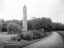
- About a mile from the town is one of the most perfect of the round towers of Ireland, 93 feet high and 50 feet in circumference at the base. It stands in the grounds of Steeple, where there is also the "Witches' Stone", a prehistoric monument.[6]
- There was a Castle, near the Six Mile Water, which was destroyed in a fire in 1922. All that remains is an octagonal tower.
- The river allowed the linen industry to be established. The linen industry has been replaced by a Technology Park, the only one in Northern Ireland.
- Antrim Market House is a 2–story building, nine bays long, three deep built in 1726. Formerly a Court House, it has recently been refurbished and is currently used as a tourist information centre and has a small theatre and cafe.
- The Castle Grounds, that is beside the Antrim Castle.
- The Springfarm Rath
Transport
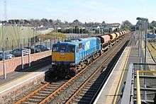
Antrim railway station was opened on 11 April 1848, and closed for goods traffic on 4 January 1965.[17] Served by passenger trains on the Belfast-Derry railway line run by Northern Ireland Railways.
Antrim's Aldergrove Airport known as Belfast International Airport is the largest airport in Northern Ireland, serving destinations in Britain, Europe and North America. However, Aldergrove does not have a proper Airport rail link connection.
%2C_August_2009.JPG)
Junction One / The Junction
Is a Retail Park With Restaurants and a Hotel
Antrim Supermarkets
Asda Superstore at The Junction / Junction One Near Antrim
lidl The Junction /. Junction One Near Antrim
Tesco Extra Castle Way Antrim
Iceland (supermarket) Market Square Antrim
Castle Mall Antrim
Castle Mall, located on High Street in the town, was formerly known as Castle Centre. It has a selection of every day shops, including the town's main Post Office.
Education
Junior Schools
- Antrim Primary School
- St Comgall's Primary School
- Greystone Primary
- Ballycraigy Primary School
- Parkhall Primary School
- St Joseph's Primary School
- Rathenraw Primary School
- Round Tower Primary School
High Schools and Colleges
- Antrim Grammar School
- Parkhall College
- St Benedict's College
- Greenmount Campus of the College of Agriculture, Food and Rural Enterprise (CAFRE)
Sport
- Naomh Comhghall Clg [18]
- Antrim Hockey Club
- Antrim Forum activity centre[19]
- Chimney Corner F.C.
- Muckamore Cricket Club
People
- Thomas McCord (1750-1824) - businessman and politician in Lower Canada
- Andrew Hunter (1813-1902) - Methodist preacher
- Joseph Stephenson-Jellie (1874-1960) - cricketer
- Eva McGown (1883-1972) - Official Hostess of Fairbanks and Honorary Hostess of Alaska
- Joe Holmes (1906-1978) - traditional musician
- Mark Allen (b. 1986) - snooker player
See also
References
- ↑ "Ballycopelann Wun-mäll – Department of the Environment" (PDF). doeni.gov.uk. Archived (PDF) from the original on 30 August 2011. Retrieved 9 May 2018.
- ↑ Languages/Cultural Diversity Archived 29 August 2011 at the Wayback Machine. Dep. of Culture, Arts and Leisure.
- ↑ The Ulster-Scot, July 2011 Archived 1 September 2011 at the Wayback Machine. Charlie 'Tha Poocher' Rennals.
- ↑ Postal Towns/Bailte Poist Archived 7 February 2012 at the Wayback Machine., Northern Ireland Place-name Project. Queen's University Belfast. Retrieved 8 March 2012.
- 1 2 Hanna, John (2002). Old Antrim. Catrine, Ayrshire: Stenlake Publishing. p. 3. ISBN 9781840331868. Archived from the original on 25 August 2015.
- 1 2 3

- ↑ "Station Locations". MetOffice. Archived from the original on 6 October 2012.
- ↑ "Annual average warmest day". Archived from the original on 7 November 2011. Retrieved 22 September 2011.
- ↑ ">25c days". Archived from the original on 6 November 2011. Retrieved 22 September 2011.
- ↑ ">Annual average coldest night". Archived from the original on 7 November 2011. Retrieved 22 September 2011.
- ↑ ">Average frost incidence". Archived from the original on 7 November 2011. Retrieved 22 September 2011.
- ↑ ">2010 minimum". Archived from the original on 18 July 2011. Retrieved 22 September 2011.
- ↑ "Aldergrove 1971–2000 averages". Met Office. Archived from the original on 13 September 2011. Retrieved 22 September 2011.
- ↑ "Statistical Classification and Delineation of Settlements" (PDF). NI Statistics and Research Agency (NISRA). February 2005. Table 3 / Band C - Large Town. Retrieved 26 September 2018.
- ↑ "Census 2011 Population Statistics for Coleraine Settlement". Northern Ireland Statistics and Research Agency (NISRA). 2011. Retrieved 5 June 2018.
- ↑ Agency, Northern Ireland Statistics and Research. "statistics". www.ninis.nisra.gov.uk. Archived from the original on 1 July 2013. Retrieved 9 May 2018.
- ↑ "Antrim" (PDF). Railscot – Irish Railways. Archived (PDF) from the original on 26 September 2007. Retrieved 27 August 2007.
- ↑ "St. Comgalls Antrim - CLG Naomh Comhghall". St. Comgalls Antrim. Archived from the original on 22 March 2018. Retrieved 9 May 2018.
- ↑ Antrim Forum website. Archived 19 May 2006 at the Wayback Machine.
External links
| Wikivoyage has a travel guide for Antrim (town). |
| Wikimedia Commons has media related to Antrim, County Antrim. |
| Large |  | |
|---|---|---|
| Medium | ||
| Small | ||
Italics denote settlements that are classed as towns but also have city status | ||
