East 180th Street (IRT White Plains Road Line)
East 180 Street | |||||||||||||||||
|---|---|---|---|---|---|---|---|---|---|---|---|---|---|---|---|---|---|
|
| |||||||||||||||||
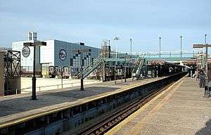 Northbound view of the station platforms, with the East 180th Street Yard off to the left. | |||||||||||||||||
| Station statistics | |||||||||||||||||
| Address |
East 180th Street & Morris Park Avenue Bronx, NY 10460 | ||||||||||||||||
| Borough | The Bronx | ||||||||||||||||
| Locale | Van Nest and West Farms | ||||||||||||||||
| Coordinates | 40°50′28″N 73°52′26″W / 40.841°N 73.874°WCoordinates: 40°50′28″N 73°52′26″W / 40.841°N 73.874°W | ||||||||||||||||
| Division | A (IRT) | ||||||||||||||||
| Line | IRT White Plains Road Line | ||||||||||||||||
| Services |
2 5 | ||||||||||||||||
| Transit connections |
| ||||||||||||||||
| Structure | Elevated | ||||||||||||||||
| Platforms |
2 island platforms cross-platform interchange | ||||||||||||||||
| Tracks | 3 | ||||||||||||||||
| Other information | |||||||||||||||||
| Opened | March 3, 1917 | ||||||||||||||||
| Station code | 426[1] | ||||||||||||||||
| Accessible |
| ||||||||||||||||
| Former/other names | East 180th Street–Morris Park Avenue | ||||||||||||||||
| Traffic | |||||||||||||||||
| Passengers (2017) |
2,589,024[2] | ||||||||||||||||
| Rank | 198 out of 425 | ||||||||||||||||
| Station succession | |||||||||||||||||
| Next north |
Gun Hill Road (White Plains express): no regular service Bronx Park East (White Plains local): 2 Pelham Parkway (Dyre express): no regular service Morris Park (Dyre local): 5 | ||||||||||||||||
| Next south |
West Farms Square–East Tremont Avenue (local): 2 Third Avenue–149th Street (express): 5 (Terminal): 5 | ||||||||||||||||
|
| |||||||||||||||||
| Next |
Gun Hill Road (White Plains express): no regular service Pelham Parkway (White Plains local): 2 none (Dyre Avenue services): 5 | ||||||||||||||||
| Next |
Simpson Street (local): 2 Third Avenue–149th Street (express): 5 none (Dyre Avenue shuttle): 5 | ||||||||||||||||
| |||||||||||||||||
| |||||||||||||||||
| |||||||||||||||||


East 180th Street (originally East 180th Street–Morris Park Avenue) is an elevated express station on the IRT White Plains Road Line of the New York City Subway. Located at the intersection of East 180th Street and Morris Park Avenue in the Bronx, it is served by the 2 and 5 trains at all times.
Station layout
| 3F | Crossover | Restricted access |
| 2F Platforms |
Southbound local | ← ← |
| Island platform, doors will open on the left, right | ||
| Peak-direction express | ← → (No service: Pelham Parkway/Esplanade (Dyre)) → (No service: Gun Hill Road/White Plains Road (Nereid)) | |
| Island platform, doors will open on the left, right | ||
| Northbound local | → → → (No service: Pelham Parkway/Esplanade (Dyre)) | |
| Gap between platforms | ||
| Former NYW&B southbound | ← No service | |
| Island platform, not in service | ||
| Former NYW&B northbound | → No service | |
| 1F | Mezzanine | Fare control, station agent |
| G | Street Level | Exit / Entrance |
The station was opened on March 3, 1917, as part of the Dual Contracts program,[3] and was one of the first in a series of stations extending the White Plains Road Line from 177th Street to 238th Street. It also served as a connection to the 1912-built New York, Westchester and Boston Railroad Administration Building and East 180th Street NYW&B station.
The NYPD's Transit District #12 resides directly across the street from the East 180th Street station at 460 Morris Park Ave.[4]
New York City Subway platforms
The New York City Subway station has two island platforms and three tracks. All 2 trains, and 5 trains at all times except rush hours and late nights, stop at the outer tracks. The center track is used by 5 service during rush hours in the peak direction (when it runs express to or from Third Avenue–149th Street) and late nights (when shuttle trains from Eastchester–Dyre Avenue terminate here). The express run to Third Avenue–149th Street is 3.4 miles (5.5 km) long and bypasses seven stations, making it the second-longest express run in the system, after the 3.5-mile (5.6 km) express run between 125th Street and 59th Street–Columbus Circle on the IND Eighth Avenue Line, which also bypasses seven stations.
The south end of the platforms has a staff-only bridge allowing access from the platforms to the East 180th Street Yard directly to the west.
Heading north, after West Farms Square–East Tremont Avenue, trains turn east and enter the S-curve to East 180th Street. To the northeast are the Unionport Yard and a signal tower; just to the northwest is the flyover that carries the southbound track of the IRT Dyre Avenue Line. The 2 train continues on the IRT White Plains Road Line to Wakefield–241st Street, while the 5 train diverges to the Dyre Avenue Line northeast. Some 5 trains continue on the White Plains Road Line during rush hours and run local to Nereid Avenue.
Exits
Until the 1980s, the station had escalators to the street level via a mezzanine, the remains of which are visible beneath the tracks. A walk is now required to reach fare control, which is in the former New York, Westchester and Boston Railway station house. A secondary exit leads to 180th Street.[5]
New York, Westchester and Boston Railway platforms
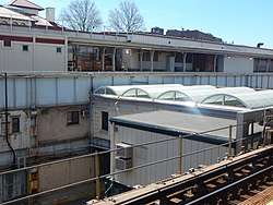
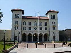
Directly to the east of the platforms are the platforms of the old New York, Westchester and Boston Railway's 180th Street station.[6] The station was designed by Fellheimer & Long with Allen H. Stem Associated Architects.[7] Its design is reminiscent of late 19th and early 20th century revivals. After the demise of NYW&B in 1937, a portion of the main line was bought by the city of New York, which converted it into the subway and renamed it the IRT Dyre Avenue Line. The line north of Dyre Avenue and south of East 180th Street was abandoned and demolished, leaving the Dyre Avenue Line with no rail connections, so subway service debuted in 1940 as a full-time shuttle.
In 1957, a flyover connection between the IRT White Plains Road and Dyre Avenue Lines opened, allowing trains from the latter to travel to Manhattan and Brooklyn. All services that formerly used the NYW&B tracks and platforms moved to the White Plains Road Line platforms and tracks. It was placed on the National Register of Historic Places on April 23, 1980.[8]
The original NYW&B station house on Morris Park Avenue is still in use as the main entrance. It is also home to some office space, a small convenience store, and until recently, a New York City Transit Police precinct (which now has a building across the street from the station entrance). Restoration of the station house was completed by MTA in 2013.[9]
Rehabilitation
From March 2010 to 2013, the station underwent a rehabilitation coordinated by Lee Harris Pomeroy Architects and completed by Citnalta Construction Corporation.[10][11] Improvements included fixing up the entrance and forecourt; replacing parts of the canopy roof, track beds, platforms and platform edges; adding new elevator access to improve circulation; and repairing electrical, mechanical, plumbing, lighting and communication equipment. Community groups hoped to see the return of businesses inside the station such as a barber shop, shoe repair, and dry cleaners which existed many decades ago.[12]
The New York City Transit Authority paid $66.6 million for the station's renovation and the Citnalta Construction Corporation contributed the cost of the 45-inch clock with Roman numerals on the facade.[13] The East 180th Street Station rehab project was completed and closed out in May 2013 at a $49.5 million cost, with another $10.4 million included for ADA access. It had been delayed six months to resolve and complete punch work.[14]
References
- ↑ "Station Developers' Information". Metropolitan Transportation Authority. Retrieved June 13, 2017.
- ↑ "Facts and Figures: Annual Subway Ridership 2012–2017". Metropolitan Transportation Authority. July 12, 2018. Retrieved July 12, 2018.
- ↑ "The Dual System of Rapid Transit (1912)". nycsubway.org.
- ↑ "Transit Bureau". New York City Police Department. June 18, 2016. Retrieved 2016-06-18.
- ↑ "MTA Neighborhood Maps: Bronx Zoo" (PDF). mta.info. Metropolitan Transportation Authority. 2015. Retrieved 20 July 2016.
- ↑ "100 Years Later, a Railroad Landmark Is Revived". The New York Times City Room Blogs.
- ↑ Potter, Janet Greenstein (1996). Great American Railroad Stations. New York: John Wiley & Sons, Inc. p. 174. ISBN 978-0471143895.
- ↑ "State Listings New York". National Register of Historic Places. Retrieved 2010-08-18.
- ↑ "MTA Restores Historic Bronx Subway Station". Metropolitan Transportation Authority. March 13, 2013.
- ↑ Dunlap, David W. (January 31, 2013). "100 Years Later, a Railroad Landmark Is Revived". The New York Times. p. A22. Retrieved November 1, 2015.
- ↑ "Lee Harris Pomery Architects, P.C." East 180th Street Station Restoration. Retrieved 2011-10-16.
- ↑ Mitchell, Max (August 25, 2010). "Station rehab may bring in new stores". Bronx-Times Reporter. p. 8. Retrieved 2011-02-09.
- ↑ Dunlap, David W. (January 31, 2013). "100 Years Later, a Railroad Landmark Is Revived". The New York Times. Retrieved 2013-03-11.
- ↑ "May 2013 Capital Program Status Report - Transit and Bus Committee" (PDF). Metropolitan Transportation Authority. July 2013. p. 4.95 (PDF p. 150).
External links
| Wikimedia Commons has media related to East 180th Street (IRT White Plains Road Line). |
- nycsubway.org – IRT White Plains Road Line: East 180th Street
- Station Reporter — 2 Train
- Station Reporter — 5 Train
- The Subway Nut — East 180th Street Pictures
- New York, Westchester and Boston Railway - East 180th Street Station
- Morris Park Avenue entrance from Google Maps Street View
- East 180th Street entrance from Google Maps Street View
- Tracks and platforms from Google Maps Street View
- Platforms from Google Maps Street View
| Preceding station | New York, Westchester and Boston Railway | Following station | ||
|---|---|---|---|---|
| Former services | ||||
| Westchester Avenue | Main Line | Morris Park | ||
| White Plains Rd. Line |
|
|---|---|
| |