Magnat-l'Étrange
| Magnat-l’Etrange | |
|---|---|
| Commune | |
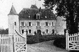 The Château du Bost, in Magnat-l'Etrange | |
 Magnat-l’Etrange Location within Nouvelle-Aquitaine region  Magnat-l’Etrange | |
| Coordinates: 45°47′41″N 2°16′45″E / 45.7947°N 2.2792°ECoordinates: 45°47′41″N 2°16′45″E / 45.7947°N 2.2792°E | |
| Country | France |
| Region | Nouvelle-Aquitaine |
| Department | Creuse |
| Arrondissement | Aubusson |
| Canton | Auzances |
| Intercommunality | Haute-Corrèze Communauté |
| Government | |
| • Mayor (2008–2014) | Lucien Mestat |
| Area1 | 25.87 km2 (9.99 sq mi) |
| Population (2008)2 | 229 |
| • Density | 8.9/km2 (23/sq mi) |
| Time zone | UTC+1 (CET) |
| • Summer (DST) | UTC+2 (CEST) |
| INSEE/Postal code | 23115 /23260 |
| Elevation | 636–868 m (2,087–2,848 ft) |
|
1 French Land Register data, which excludes lakes, ponds, glaciers > 1 km2 (0.386 sq mi or 247 acres) and river estuaries. 2 Population without double counting: residents of multiple communes (e.g., students and military personnel) only counted once. | |
Magnat-l’Etrange is a commune in the Creuse department in the Nouvelle-Aquitaine region in central France.
Geography
An area of farming and forestry, lakes and streams, comprising the village and several hamlets situated some 14 miles (23 km) southeast of Aubusson, at the junction of the D25, D28, D31 and the D32 roads. The commune is within the natural park of the Millevaches (1000 lakes, not cows).
Population
| Historical population | ||
|---|---|---|
| Year | Pop. | ±% |
| 1962 | 460 | — |
| 1968 | 462 | +0.4% |
| 1975 | 384 | −16.9% |
| 1982 | 318 | −17.2% |
| 1990 | 245 | −23.0% |
| 1999 | 212 | −13.5% |
| 2008 | 229 | +8.0% |
Sights
- The church, dating from the eleventh century.
- The fifteenth-century château.
- The Château Dubost, dating from the sixteenth century.
See also
References
External links
| Wikimedia Commons has media related to Magnat-l'Étrange. |
- Magnat-l’Etrange on the Quid website (in French)
This article is issued from
Wikipedia.
The text is licensed under Creative Commons - Attribution - Sharealike.
Additional terms may apply for the media files.