Arthur County, Nebraska
| Arthur County, Nebraska | |
|---|---|
 Arthur County Courthouse in Arthur | |
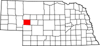 Location in the U.S. state of Nebraska | |
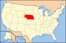 Nebraska's location in the U.S. | |
| Founded | 1913 |
| Named for | Chester A. Arthur |
| Seat | Arthur |
| Largest village | Arthur |
| Area | |
| • Total | 718 sq mi (1,860 km2) |
| • Land | 715 sq mi (1,852 km2) |
| • Water | 3.0 sq mi (8 km2), 0.4% |
| Population | |
| • (2010) | 460 |
| • Density | 0.6/sq mi (0.2/km2) |
| Congressional district | 3rd |
| Time zone | Mountain: UTC−7/−6 |
Arthur County is a county in the U.S. state of Nebraska. As of the 2010 census, the population was 460,[1] making it Nebraska's least populous county and the fifth-least populous county in the United States (behind only Loving County, Texas, Kalawao County, Hawaii, King County, Texas, and Kenedy County, Texas). Its county seat and only incorporated community is Arthur.[2]
In the Nebraska license plate system, Arthur County is represented by the prefix 91 (it had the 91st-largest number of vehicles registered in the county when the license plate system was established in 1922).
Arthur County contains the historic First Arthur County Courthouse and Jail, believed to be the smallest courthouse in the United States.[3]
History
Arthur County was formally established in 1913 from what had been the western part of McPherson County following an effort to move the McPherson County seat from Tryon to the more centrally located Flats: rather than lose the county seat, the residents of Tryon, Nebraska agreed to have the county divided approximately in half, according to boundaries for sandhills counties originally proposed in 1887. The half which became Arthur County had been in the process of settlement by 1884, by ranchers seeking open grazing land. The placement of a post office at Lena in 1894 and the passage of the homesteading act in 1904 further influenced the county's founding and expedited the new county's establishment processes.
The new county was named after President Chester A. Arthur, and the village of Arthur, similarly named, was established to serve as the county seat.[4] Principal postal service moved from Lena to the village of Arthur in 1914, which also held the county's public schools, general store, bank and co-op, principal churches, newspaper and other businesses and services, all aimed at facilitating the county's rural lifestyle.
As of the 1920 census, 1,412 people made their homes and livings in Arthur County, which was then and has remained entirely rural, essentially ranching. Although the village of Arthur underwent electrification in the 1920s, most of the county did not see power or telephone services until 1950-1951. At that time also, highway construction and improvements facilitated transportation, which was especially dependent upon the north-south running State Highway 61 and the east-west running Highway 92: motor vehicles were the sole means of mechanical transportation throughout Arthur's history as no railroad ever crossed into it. Irrigation of the sandhills land had been begun by 1900 and continued through the first half of the twentieth century, with center-pivot irrigaton dominating. The population peaked around 1930 at 1,344 persons, but began to decline in response to the Great Depression. By 1950, the county population was down to 803, by 1980 down to 513.
Geography
According to the U.S. Census Bureau, the county has an area of 718 square miles (1,860 km2), of which 715 square miles (1,850 km2) is land and 3.0 square miles (7.8 km2) (0.4%) is water.[5]
Major highways
Adjacent counties
- Grant County, Nebraska - north
- Hooker County, Nebraska - northeast
- McPherson County, Nebraska - east
- Keith County, Nebraska - south
- Garden County, Nebraska - west
Demographics
| Historical population | |||
|---|---|---|---|
| Census | Pop. | %± | |
| 1920 | 1,412 | — | |
| 1930 | 1,344 | −4.8% | |
| 1940 | 1,045 | −22.2% | |
| 1950 | 803 | −23.2% | |
| 1960 | 680 | −15.3% | |
| 1970 | 606 | −10.9% | |
| 1980 | 513 | −15.3% | |
| 1990 | 462 | −9.9% | |
| 2000 | 444 | −3.9% | |
| 2010 | 460 | 3.6% | |
| Est. 2016 | 469 | [6] | 2.0% |
| U.S. Decennial Census[7] 1790-1960[8] 1900-1990[9] 1990-2000[10] 2010-2013[1] | |||
As of the census[11] of 2000, there were 444 people, 185 households, and 138 families residing in the county. The population density was 0.618 people per square mile (0.239/km²). There were 273 housing units at an average density of 0.380 per square mile (0.147/km²). The racial makeup of the county was 96.40% White, 0.23% Native American, 0.68% Asian, 0.23% Pacific Islander, 0.90% from other races, and 1.58% from two or more races. 1.35% of the population were Hispanic or Latino of any race. 50.4% were of German, 13.1% English, 6.2% Irish and 5.7% Swedish ancestry according to Census 2000.
There were 185 households out of which 27.60% had children under the age of 18 living with them, 63.20% were married couples living together, 7.60% had a female householder with no husband present, and 25.40% were non-families. 21.60% of all households were made up of individuals and 10.80% had someone living alone who was 65 years of age or older. The average household size was 2.40 and the average family size was 2.80.
In the county, the population was spread out with 23.90% under the age of 18, 5.40% from 18 to 24, 29.50% from 25 to 44, 24.80% from 45 to 64, and 16.40% who were 65 years of age or older. The median age was 40 years. For every 100 females there were 101.80 males. For every 100 females age 18 and over, there were 107.40 males.
The median income for a household in the county was $27,375, and the median income for a family was $31,979. Males had a median income of $21,544 versus $13,125 for females. The per capita income for the county was $15,810. About 7.90% of families and 13.80% of the population were below the poverty line, including 15.10% of those under age 18 and 7.80% of those age 65 or over.
Religion
More than 50% of the county residents are Baptists,[12] making it the most northern majority Baptist county in the United States.[12]
Communities
Village
- Arthur (county seat)
Unincorporated communities
See also
References
- 1 2 "State & County QuickFacts". United States Census Bureau. Retrieved September 17, 2013.
- ↑ "Find a County". National Association of Counties. Archived from the original on 2011-05-31. Retrieved 2011-06-07.
- ↑ Jones, Melissa (2005). Superlatives USA: The Largest, Smallest, Longest, Shortest, and Wackiest Sites in America. Capital Books. p. 82. ISBN 978-1-931868-85-3.
- ↑ "Archived copy". Archived from the original on 2008-07-04. Retrieved 2008-03-15. Retrieved on March 15, 2008.
- ↑ "2010 Census Gazetteer Files". United States Census Bureau. August 22, 2012. Archived from the original on November 13, 2013. Retrieved December 3, 2014.
- ↑ "Population and Housing Unit Estimates". Retrieved June 9, 2017.
- ↑ "U.S. Decennial Census". United States Census Bureau. Archived from the original on May 12, 2015. Retrieved December 3, 2014.
- ↑ "Historical Census Browser". University of Virginia Library. Retrieved December 3, 2014.
- ↑ "Population of Counties by Decennial Census: 1900 to 1990". United States Census Bureau. Retrieved December 3, 2014.
- ↑ "Census 2000 PHC-T-4. Ranking Tables for Counties: 1990 and 2000" (PDF). United States Census Bureau. Retrieved December 3, 2014.
- ↑ "American FactFinder". United States Census Bureau. Archived from the original on 2013-09-11. Retrieved 2008-01-31.
- 1 2 "Archived copy". Archived from the original on 2010-05-22. Retrieved 2004-09-27.
Places adjacent to Arthur County, Nebraska | ||||||||||
|---|---|---|---|---|---|---|---|---|---|---|
| ||||||||||
External links
Municipalities and communities of Arthur County, Nebraska, United States | ||
|---|---|---|
| Village | ||
| Unincorporated communities | ||