| Park name |
County or counties |
Size[2] |
Date
founded |
River / lake / other |
Image |
Remarks |
| acres |
ha |
| Alewife Brook Reservation | Middlesex
42°23′48″N 71°8′38″W / 42.39667°N 71.14389°W / 42.39667; -71.14389 (Alewife Brook Reservation) | 136 acres |
55 ha | | Little Pond, Little River, Alewife Brook | | A major portion of the Alewife Reservation is designated wetland. The Reservation is located at the end of the Minuteman Bike Path in Arlington |
| Ames Nowell State Park | Plymouth
42°7′12.8994″N 70°59′13.632″W / 42.120249833°N 70.98712000°W / 42.120249833; -70.98712000 (Ames Nowell State Park) | 612 acres |
248 ha | | Cleveland Pond | | The park is primarily used for boating and fishing. |
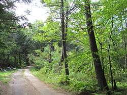
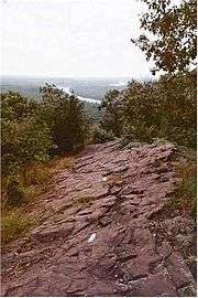
| Appalachian Trail | Berkshire
42°28′57.8″N 73°10′46.7″W / 42.482722°N 73.179639°W / 42.482722; -73.179639 (Appalachian Trail) | 90 mi |
140 km | | | | 90 miles (145 km) of this trail are in Massachusetts. |
| Ashland State Park | Middlesex
42°14′30″N 71°27′58″W / 42.24167°N 71.46611°W / 42.24167; -71.46611 (Ashland State Park) | 472 acres |
191 ha | | Ashland Reservoir | | |
| Ashuwillticook Rail Trail | Berkshire
42°33′14″N 73°9′55″W / 42.55389°N 73.16528°W / 42.55389; -73.16528 (Ashuwillticook Rail Trail) | 11 mi |
18 km | | Cheshire Reservoir, Hoosic River | | |
| Bash Bish Falls State Park | Berkshire
42°06′53″N 73°29′34″W / 42.11472°N 73.49278°W / 42.11472; -73.49278 (Bash Bish Falls State Park) | 424 acres |
172 ha | | Bash Bish Falls | | Massachusetts' highest single-drop waterfall lies within the park borders. |
| Beartown State Forest | Berkshire
42°14′00″N 73°16′28″W / 42.23333°N 73.27444°W / 42.23333; -73.27444 (Beartown State Forest) | 120 acres |
49 ha | | Benedict Pond | | Approximately 7.5 miles (12.1 km) of the Appalachian Trail travels through the forest. |
| Beaver Brook Reservation | Middlesex
42°23′26″N 71°11′52″W / 42.39056°N 71.19778°W / 42.39056; -71.19778 (Beaver Brook Reservation) | 303 acres |
123 ha | | | | The park includes a cascading waterfall and a wading pool. |
| Belle Isle Marsh Reservation | Suffolk
42°23′21″N 70°59′21″W / 42.38917°N 70.98917°W / 42.38917; -70.98917 (Belle Isle Marsh Reservation) | 188 acres |
76 ha | | Belle Isle Marsh | | The reservation includes landscaped pathways, benches, and an observation tower. A portion of the Boston Harborwalk runs through the reservation. |
| Blackstone River and Canal Heritage State Park | Worcester
42°05′40″N 71°37′23″W / 42.09444°N 71.62306°W / 42.09444; -71.62306 (Blackstone River and Canal Heritage State Park) | 1,066 acres |
431 ha | | Blackstone River | | The park is the midpoint of the Blackstone River Valley National Heritage Corridor of the National Park System. |
| Blue Hills Reservation | Norfolk
42°12′40″N 71°7′40″W / 42.21111°N 71.12778°W / 42.21111; -71.12778 (Blue Hills Reservation) | 6,165 acres |
2,495 ha | | Houghton's Pond, Ponkapoag Pond | | The reservation has the distinction of being the largest conservation land within a major metropolitan area. |
| Borderland State Park | Bristol, Norfolk
42°4′3″N 71°9′13″W / 42.06750°N 71.15361°W / 42.06750; -71.15361 (Borderland State Park) | 1,843 acres |
746 ha | 1971 | | | On National Register of Historic Places |
| Boston Harbor Islands State Park | Norfolk, Plymouth, Suffolk
42°19′11.6″N 70°55′45.6″W / 42.319889°N 70.929333°W / 42.319889; -70.929333 (Boston Harbor Islands State Park) | 404 acres |
163 ha | 1996 | Boston Harbor | | |
| Bradley Palmer State Park | Essex
42°38′0″N 70°53′43″W / 42.63333°N 70.89528°W / 42.63333; -70.89528 (Bradley Palmer State Park) | 736 acres |
298 ha | | Ipswich River | | The park that features rolling meadows, lush evergreens and old carriage roads lined with rhododendrons. |
| Breakheart Reservation | Essex, Middlesex
42°29′21″N 71°2′23″W / 42.48917°N 71.03972°W / 42.48917; -71.03972 (Breakheart Reservation) | 652 acres |
264 ha | | Silver Lake, Pearce Lake, Saugus River | | The reservation is hardwood forest principally used for birding, fishing and hiking. |
| Brimfield State Forest | Hampden
42°6′0″N 72°14′56″W / 42.10000°N 72.24889°W / 42.10000; -72.24889 (Brimfield State Forest) | 3,523 acres |
1,426 ha | | Dean Pond | | |
| Bristol Blake State Reservation | Norfolk
42°6′28.6″N 71°19′5″W / 42.107944°N 71.31806°W / 42.107944; -71.31806 (Bristol Blake State Reservation) | 140 acres |
57 ha | | | | Adjacent to Stony Brook Wildlife Sanctuary |
| Brook Farm Historic Site | Suffolk
42°17′29″N 71°10′26.7″W / 42.29139°N 71.174083°W / 42.29139; -71.174083 (Brook Farm Historic Site) | 141 acres |
57 ha | | | | |
| C. M. Gardner State Park | Hampden
42°16′31″N 72°52′14.5″W / 42.27528°N 72.870694°W / 42.27528; -72.870694 (C. M. Gardner State Park) | 85 acres |
34 ha | | Westfield River | | |
| Callahan State Park | Middlesex
42°20′35″N 71°26′55″W / 42.34306°N 71.44861°W / 42.34306; -71.44861 (Callahan State Park) | 958 acres |
388 ha | | | | |
| Camp Nihan Environmental Education Camp | Essex
42°29′32.6″N 71°1′11.4″W / 42.492389°N 71.019833°W / 42.492389; -71.019833 (Camp Nihan Environmental Education Camp) | 65 acres |
26 ha | 1929 | Saugus River | | Part of Breakheart Reservation |
| Canalside Rail Trail | Franklin
42°36′37.2″N 72°33′18.1″W / 42.610333°N 72.555028°W / 42.610333; -72.555028 (Canalside Rail Trail) | 3.7 mi |
6.0 km | 2008 | | | Trail along the Connecticut River |
| Cape Cod Rail Trail | Barnstable
41°46′32.1″N 70°1′54.4″W / 41.775583°N 70.031778°W / 41.775583; -70.031778 (Cape Cod Rail Trail) | 188 acres |
76 ha | | | | 22-mile trail on Cape Cod |
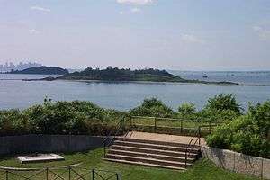
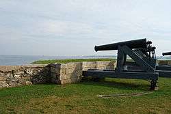
| Castle Island | Suffolk
42°20′15″N 71°0′38″W / 42.33750°N 71.01056°W / 42.33750; -71.01056 (Castle Island) | 22 acres |
8.9 ha | | Boston Harbor | | The present fort, built between 1834 and 1851, is the eighth generation of forts and it is one of the oldest fortified sites in British North America. |
| Charles River Reservation | Suffolk, Middlesex
42°21′20″N 71°6′56″W / 42.35556°N 71.11556°W / 42.35556; -71.11556 (Charles River Reservation) | 863 acres |
349 ha | | Charles River | | Includes Charles River Dam, Charles River Basin and Esplanade, John F. Kennedy Park, and Teddy Ebersol’s Red Sox Fields. Covers Charles River below Watertown Dam; see also Upper Charles River Reservation |
| Chester-Blandford State Forest | Hampden
42°14′58″N 72°56′58″W / 42.24944°N 72.94944°W / 42.24944; -72.94944 (Chester-Blandford State Forest) | 2,776 acres |
1,123 ha | | | | |
| Chestnut Hill Reservation | Suffolk
42°20′7″N 71°9′29″W / 42.33528°N 71.15806°W / 42.33528; -71.15806 (Chestnut Hill Reservation) | 1 acre |
0.40 ha | 1870 | Chestnut Hill Reservoir | | The Chestnut Hill Reservoir Historic District is considered a nineteenth-century masterpiece of engineering, urban planning and landscape design. |
| Chicopee Memorial State Park | Hampden
42°10′45″N 72°32′13″W / 42.17917°N 72.53694°W / 42.17917; -72.53694 (Chicopee Memorial State Park) | 562 acres |
227 ha | | Cooley Brook Reservoir | | The park includes two 25-acre (10 ha) ponds. |
| Clarksburg State Park | Berkshire
42°44′5″N 73°4′35″W / 42.73472°N 73.07639°W / 42.73472; -73.07639 (Clarksburg State Park) | 3,629 acres |
1,469 ha | | Mauserts Pond | | Adjoins 7003301100000000000♠3,011 acre Clarksburg State Forest |
| Cochituate State Park | Middlesex
42°18′45″N 71°22′27″W / 42.31250°N 71.37417°W / 42.31250; -71.37417 (Cochituate State Park) | 872 acres |
353 ha | | Lake Cochituate | | |
| Connecticut River Greenway State Park | Franklin, Hampden, Hampshire
42°36′27″N 72°32′30″W / 42.60750°N 72.54167°W / 42.60750; -72.54167 (Connecticut River Greenway State Park) | 1,048 acres |
424 ha | | Connecticut River | | Multiple state land holdings in the Pioneer Valley of Western Massachusetts |
| Constitution Beach | Suffolk
42°23′5.5″N 71°0′36.2″W / 42.384861°N 71.010056°W / 42.384861; -71.010056 (Constitution Beach) | 82 acres |
33 ha | | Boston Harbor | | |
| Cutler Park Reservation | Norfolk
42°16′16″N 71°11′45″W / 42.27111°N 71.19583°W / 42.27111; -71.19583 (Cutler Park Reservation) | 739 acres |
299 ha | | Charles River | | It contains the largest remaining fresh water marsh on the middle Charles, and includes a boardwalk through a cattail marsh out onto an island. |
| D.A.R. State Forest | Hampshire
42°27′25″N 72°47′50″W / 42.45694°N 72.79722°W / 42.45694; -72.79722 (D.A.R. State Forest) | 1,728 acres |
699 ha | 1929 | Upper and Lower Highland Lake | | |
| Demarest Lloyd State Park | Bristol
41°31′44″N 70°59′0″W / 41.52889°N 70.98333°W / 41.52889; -70.98333 (Demarest Lloyd State Park) | 200 acres |
81 ha | | Buzzards Bay | | |
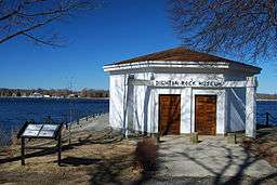
| Dighton Rock State Park | Bristol
41°48′46″N 71°6′23″W / 41.81278°N 71.10639°W / 41.81278; -71.10639 (Dighton Rock State Park) | 98 acres |
40 ha | | Taunton River | | Dighton Rock is an 11-foot (3.4 m) high glacial erratic covered with petroglyphs and has since been moved to a museum at the park. |
| Dorchester Shores Reservation | Suffolk
42°17′50″N 71°2′44″W / 42.29722°N 71.04556°W / 42.29722; -71.04556 (Dorchester Shores Reservation) | 44 acres |
18 ha | | Neponset River | | The reservation comprises two beaches and a park. |
| Douglas State Forest | Worcester
42°3′30″N 71°47′13″W / 42.05833°N 71.78694°W / 42.05833; -71.78694 (Douglas State Forest) | 5,525 acres |
2,236 ha | | Wallum Lake | | Features include a rare Atlantic White Cedar swamp and 7.8 miles (12.6 km) of the Midstate Trail |
| Dunn State Park | Worcester
42°34′48″N 71°58′12″W / 42.58000°N 71.97000°W / 42.58000; -71.97000 (Dunn State Park) | 132 acres |
53 ha | | Dunn Pond | | |
| Ellisville Harbor State Park | Plymouth
41°50′34″N 70°32′13″W / 41.84278°N 70.53694°W / 41.84278; -70.53694 (Ellisville Harbor State Park) | 97 acres |
39 ha | | Cape Cod Bay | | Walking trails overlooking a tidal marsh, sandy/rocky beach at trail end |
| Elm Bank Reservation | Norfolk
42°16′34″N 71°18′9″W / 42.27611°N 71.30250°W / 42.27611; -71.30250 (Elm Bank Reservation) | 175 acres |
71 ha | c. 1996 | Charles River | | Benjamin Pierce Cheney's property, now run by Massachusetts Horticultural Society |
| Erving State Forest | Franklin
42°37′21″N 72°22′41″W / 42.62250°N 72.37806°W / 42.62250; -72.37806 (Erving State Forest) | 2,422 acres |
980 ha | | Millers River | | The 110-mile (180 km) Metacomet-Monadnock Trail passes through a western parcel of the state forest. |
| F. Gilbert Hills State Forest | Norfolk
42°3′28″N 71°17′0″W / 42.05778°N 71.28333°W / 42.05778; -71.28333 (F. Gilbert Hills State Forest) | 1,030 acres |
420 ha | | | | |
| Fall River Heritage State Park | Bristol
41°42′20″N 71°9′38″W / 41.70556°N 71.16056°W / 41.70556; -71.16056 (Fall River Heritage State Park) | 14 acres |
5.7 ha | | Taunton River | | |
| Federated Women's Club State Forest | Worcester
42°29′27″N 72°15′15″W / 42.49083°N 72.25417°W / 42.49083; -72.25417 (Federated Women's Club State Forest) | 970 acres |
390 ha | | Fever Brook | | |
| Fort Phoenix State Reservation | Bristol
41°37′27″N 70°53′56″W / 41.62417°N 70.89889°W / 41.62417; -70.89889 (Fort Phoenix State Reservation) | 1 acre |
0.40 ha | | Atlantic Ocean | | Revolutionary War fort; 1/2 mile of Buzzards Bay beachfront |
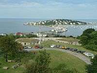
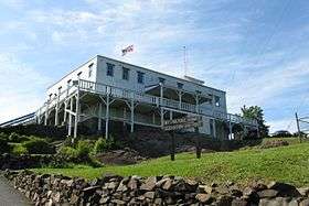
| Fort Revere Park | Plymouth
42°18′17″N 70°54′21″W / 42.30472°N 70.90583°W / 42.30472; -70.90583 (Fort Revere Park) | 6 acres |
2.4 ha | | Atlantic Ocean | | On Telegraph Hill in Hull, Massachusetts. Remnants of two seacoast fortifications, water tower with observation deck, military history museum and picnic facilities |
| Francis D. Martini Memorial Shell Park and Moynihan Recreation Area | Suffolk
42°14′36″N 71°7′37″W / 42.24333°N 71.12694°W / 42.24333; -71.12694 (Francis D. Martini Memorial Shell Park and Moynihan Recreation Area) | 5.6 acres |
2.3 ha | | Neponset River | | Outdoor theatre and play fields |
| Freetown-Fall River State Forest | Bristol
41°45′28″N 71°3′48″W / 41.75778°N 71.06333°W / 41.75778; -71.06333 (Freetown-Fall River State Forest) | 5,217 acres |
2,111 ha | 1930 | | | The park includes Profile Rock, a granite outcropping which local Native Americans believe to be the image of Chief Massasoit. Also in the forest is a 227-acre (92 ha) Wampanoag reservation |
| Gardner Heritage State Park | Worcester
42°34′38″N 71°59′39″W / 42.57722°N 71.99417°W / 42.57722; -71.99417 (Gardner Heritage State Park) | 0 acres |
0 ha | | | | Restored 19th century fire station with exhibits; closed |
| Georgetown-Rowley State Forest | Essex
42°42′5″N 70°58′26″W / 42.70139°N 70.97389°W / 42.70139; -70.97389 (Georgetown-Rowley State Forest) | 1,041 acres |
421 ha | | | | |
| Granville State Forest | Hampden
42°3′35″N 72°58′17″W / 42.05972°N 72.97139°W / 42.05972; -72.97139 (Granville State Forest) | 2,432 acres |
984 ha | | Hubbard River | | |
| Great Brook Farm State Park | Middlesex
42°33′21″N 71°21′12″W / 42.55583°N 71.35333°W / 42.55583; -71.35333 (Great Brook Farm State Park) | 909 acres |
368 ha | | Meadow Pond | | |
| Greycourt State Park | Essex
42°43′46″N 71°10′51″W / 42.72944°N 71.18083°W / 42.72944; -71.18083 (Greycourt State Park) | 24 acres |
9.7 ha | 2001 | | | The park is built atop the restored ruins of the Charles H. Tenney estate. |
| Halibut Point State Park | Essex
42°41′22″N 70°37′59″W / 42.68944°N 70.63306°W / 42.68944; -70.63306 (Halibut Point State Park) | 55 acres |
22 ha | | | | Features a former granite quarry and 60-foot (18 m) tower with coastal views |
| Hammond Pond Reservation | Middlesex
42°19′30″N 71°10′36″W / 42.32500°N 71.17667°W / 42.32500; -71.17667 (Hammond Pond Reservation) | 59 acres |
24 ha | | | | |
| Hampton Ponds State Park | Hampden
42°10′45″N 72°41′22″W / 42.17917°N 72.68944°W / 42.17917; -72.68944 (Hampton Ponds State Park) | 47 acres |
19 ha | | Pequot Pond | | |
| Harold Parker State Forest | Essex
42°37′33″N 71°4′54″W / 42.62583°N 71.08167°W / 42.62583; -71.08167 (Harold Parker State Forest) | 3,320 acres |
1,340 ha | | Stearns Pond | | |
| Hemlock Gorge Reservation | Middlesex
42°18′52″N 71°13′35″W / 42.31444°N 71.22639°W / 42.31444; -71.22639 (Hemlock Gorge Reservation) | 16 acres |
6.5 ha | | Charles River | | |
| Holyoke Heritage State Park | Hampden
42°12′18″N 72°36′26″W / 42.20500°N 72.60722°W / 42.20500; -72.60722 (Holyoke Heritage State Park) | 7 acres |
2.8 ha | | | | The park features include a visitor center with exhibits about paper manufacturing and Holyoke's industrial and cultural history. |
| Hopkinton State Park | Middlesex
42°14′57″N 71°31′32″W / 42.24917°N 71.52556°W / 42.24917; -71.52556 (Hopkinton State Park) | 1,245 acres |
504 ha | | Hopkinton Reservoir | | The park features a bathing pond for swimming that is physically separated from the reservoir, where nonmotorized boating is permitted |
| Horseneck Beach State Reservation | Bristol
41°30′28″N 71°2′55″W / 41.50778°N 71.04861°W / 41.50778; -71.04861 (Horseneck Beach State Reservation) | 815 acres |
330 ha | | | | Popular for its two-mile (3 km) long sandy beach on the shore of Buzzards Bay. Also camping, fishing and a salt marsh. |
| Jug End State Reservation and Wildlife Management Area | Berkshire | 1,191 acres |
482 ha | | | | |
| Kenneth Dubuque Memorial State Forest | Franklin | 7,405 acres |
2,997 ha | 1997 | Hallockville Pond, Crooked Pond | | |
| Lake Dennison Recreation Area | Worcester | 121 acres |
49 ha | | Lake Dennison | | The park is an extension of Otter River State Forest |
| Lake Lorraine State Park | Hampden | 3 acres |
1.2 ha | | | | |
| Lake Wyola State Park | Franklin | 42 acres |
17 ha | | Lake Wyola | | |
| Lawrence Heritage State Park | Essex | 0 acres |
0 ha | | | | |
| Leominster State Forest | Worcester | 4,246 acres |
1,718 ha | | | | The Midstate Trail runs through the western edge of the forest. |
| Lowell-Dracut-Tyngsboro State Forest | Middlesex | 1,109 acres |
449 ha | | | | |
| Lowell Heritage State Park | Middlesex | 60 acres |
24 ha | 1975 | Merrimack River | | Precursor to Lowell National Historical Park; preserves the city's seminal role in the American Industrial Revolution |
| Lower Neponset River Trail | Suffolk | 2.4 mi |
3.9 km | | | | |
| Lynn Heritage State Park | Essex | 4 acres |
1.6 ha | | | | |
| Lynn Shore Reservation | Essex | 22 acres |
8.9 ha | | | | |
| Mahican-Mohawk Trail | Berkshire, Franklin | 30 mi |
48 km | | Deerfield River | | In development |
| Manuel F. Correllus State Forest | Dukes | 5,215 acres |
2,110 ha | 1908 | Little Pond | | In the interior of Martha's Vineyard, the park is the focus of one of the largest environmental restoration projects in the country. |
| Massasoit State Park | Bristol | 1,207 acres |
488 ha | | Lake Rico, Furnace Pond, King's Pond, Middle Pond, Little Bearhole Pond, and Big Bearhole Pond | | |
| Maudslay State Park | Essex | 483 acres |
195 ha | | Merrimack River | | |
| Middlesex Fells Reservation | Middlesex | 2,283 acres |
924 ha | | Bellevue and Spot Ponds | | |
| Mohawk Trail State Forest | Franklin | 7,758 acres |
3,140 ha | | | | Includes Cold River Virgin Forest, National Natural Landmark |
| Monroe State Forest | Franklin | 3,750 acres |
1,520 ha | | Dunbar Brook | | |
| Moore State Park | Worcester | 737 acres |
298 ha | | Eames Pond | | |
| Mount Everett State Reservation | Berkshire | 2,492 acres |
1,008 ha | | Guilder Pond | | |
| Mount Grace State Forest | Franklin | 1,578 acres |
639 ha | | | | |
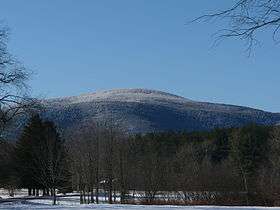
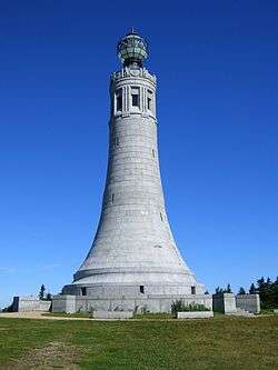
| Mount Greylock State Reservation | Berkshire | 12,455 acres |
5,040 ha | 1898 | | | |
| Mount Holyoke Range State Park | Hampshire | 3,000 acres |
1,200 ha | | | | |
| Mount Sugarloaf State Reservation | Franklin | 533 acres |
216 ha | | | | |
| Mount Tom State Reservation | Hampden | 1,967 acres |
796 ha | | | | |
| Mount Washington State Forest | Berkshire | 4,619 acres |
1,869 ha | | | | |
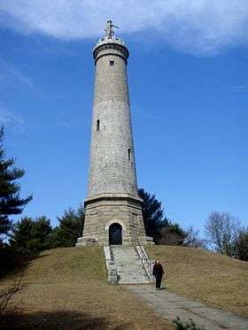
| Myles Standish Monument State Reservation | Plymouth | 30 acres |
12 ha | | | | A 120-foot (37 m) tower with 125 steps that overlooks Plymouth Harbor and Duxbury Beach. |
| Myles Standish State Forest | Plymouth | 12,029 acres |
4,868 ha | | | | Pitch pine and scrub oak forest with sixteen ponds for fishing, canoeing, swimming. Camping on four of the ponds, bicycle trails, equestrian trails, and horse camping. |
| Mystic River Reservation | Middlesex | 359 acres |
145 ha | 1893 | Mystic Lakes; Mystic River | | |
| Nahant Beach Reservation | Essex | 67 acres |
27 ha | | Atlantic Ocean | | |
| Nantasket Beach Reservation | Plymouth | 39 acres |
16 ha | | | | |
| Nashua River Rail Trail | Middlesex | 57 acres |
23 ha | | | | |
| Nasketucket Bay State Reservation | Plymouth | 210 acres |
85 ha | 1999 | | | |
| Natural Bridge State Park | Berkshire | 44 acres |
18 ha | | Hudson Brook | | It contains the only natural white marble arch/bridge in North America. The natural bridge spanning Hudson Brook, was formed by glacial melt about 11,000 BC, from 550 million year old bedrock. |
| Neponset River Reservation | Suffolk | 1,880 acres |
760 ha | | | | |
| Nickerson State Park | Barnstable | 1,967 acres |
796 ha | | Cliff Pond | | |
| Norwottuck Rail Trail | Hampshire | 61 acres |
25 ha | 1992 | Connecticut River | | |
| October Mountain State Forest | Berkshire | 16,460 acres |
6,660 ha | | | | |
| Otter River State Forest | Worcester | 1,022 acres |
414 ha | 1915 | Otter River, Millers River | | |
| Pearl Hill State Park | Middlesex | 1,000 acres |
400 ha | | Park Hill Brook | | |
| Pilgrim Memorial State Park | Plymouth | 6 acres |
2.4 ha | | | | Site of Plymouth Rock |
| Pittsfield State Forest | Berkshire | 10,601 acres |
4,290 ha | | | | |
| Pope John Paul II Park Reservation | Suffolk | 66 acres |
27 ha | 2001 | Neponset River Estuary | | Reclaimed former landfill and commercial area |
| Purgatory Chasm State Reservation | Worcester | 100 acres |
40 ha | 1919 | | | The Chasm was created when glacial meltwater from a burst ice dam ripped out blocks of bedrock at the end of the last Ice Age (14,000 years ago). |
| Quabbin Reservoir | Hampshire | 39 sq mi |
100 km2 | | | | |
| Quincy Quarries Reservation | Norfolk | 22 acres |
8.9 ha | 1985 | | | |
| Quincy Shores Reservation | Norfolk | 87 acres |
35 ha | | | | |
| Quinsigamond State Park | Worcester | 38 acres |
15 ha | | | | |
| Revere Beach Reservation | Suffolk | 84 acres |
34 ha | 1896 | | | |
| Robinson State Park | Hampden | 1,025 acres |
415 ha | | Westfield River | | |
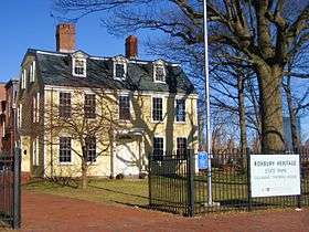
| Roxbury Heritage State Park | Suffolk | 3 acres |
1.2 ha | | | | The 1750 Dillaway-Thomas House and a small park |
| Rumney Marsh Reservation | Essex, Suffolk | 815 acres |
330 ha | | Saugus River; Pines River | | |
| Rutland State Park | Worcester | 284 acres |
115 ha | | Whitehall Pond | | Swimming, picnicking and boating. |
| Salisbury Beach State Reservation | Essex | 355 acres |
144 ha | | | | The park's main feature is its 3.8-mile (6.1 km)-long beach, one of the most popular in the Commonwealth. |
| Sandisfield State Forest | Berkshire | 4,190 acres |
1,700 ha | | York Lake | | |
| Sandy Point State Reservation | Essex | 134 acres |
54 ha | | | | |
| Savoy Mountain State Forest | Berkshire | 10,457 acres |
4,232 ha | | | | |
| Scusset Beach State Reservation | Barnstable | 459 acres |
186 ha | | | | On Cape Cod Bay at the east end of the Cape Cod Canal, a popular swimming and camping area. |
| Shawme-Crowell State Forest | Barnstable | 624 acres |
253 ha | | | | Forested 285 site campground |
| J.A. Skinner State Park | Hampshire | 843 acres |
341 ha | | Connecticut River | | |
| South Cape Beach State Park | Barnstable | 460 acres |
190 ha | | | | A component of the Waquoit Bay National Estuarine Research Reserve with a one-mile (1.6 km) stretch of beach. |
| Southern New England Trunkline Trail | Norfolk, Worcester | 33 acres |
13 ha | | | | 22-mile trail from Franklin State Forest to Douglas State Forest |
| Southwest Corridor Park | Suffolk | 221 acres |
89 ha | | | | Greenway of 4.7 miles (7.6 km) that runs South End, Back Bay, Roxbury and Jamaica Plain neighborhoods |
| Spencer State Forest | Worcester | 903 acres |
365 ha | | Howe Pond | | |
| Squantum Point Park | Norfolk | 46 acres |
19 ha | 2001 | | | |
| Stony Brook Reservation | Suffolk | 616 acres |
249 ha | | Turtle Pond | | |
| Streeter Point Recreation Area | Worcester | 1 acre |
0.40 ha | | East Brimfield Reservoir | | Fishing, swimming, picnicking |
| Sudbury Reservoir | Middlesex; Worcester | 4,943 acres |
2,000 ha | | Sudbury Reservoir | | |
| Tolland State Forest | Berkshire | 4,415 acres |
1,787 ha | | Otis Reservoir | | |
| Upper Charles River Reservation | Middlesex, Norfolk, Suffolk | 863 acres |
349 ha | | Charles River | | Covers Charles River between Watertown Dam and Riverdale Park, West Roxbury; see also Charles River Reservation |
| Upton State Forest | Worcester | 2,790 acres |
1,130 ha | | | | Has Civilian Conservation Corps structures |
| Wachusett Mountain State Reservation | Worcester | 2,288 acres |
926 ha | | | | |
| Wachusett Reservoir | Worcester | 4,135 acres |
1,673 ha | | Nashua River; Quinapoxet River | | |
| Wahconah Falls State Park | Berkshire | 48 acres |
19 ha | | Wahconah Falls Brook | | |
| Walden Pond State Reservation | Middlesex | 335 acres |
136 ha | 1922 | Walden Pond | | |
| Waquoit Bay National Estuarine Research Reserve | Barnstable | 110 acres |
45 ha | | Waquoit Bay; Quashnet River; Childs River; ponds | | |
| Ware River Watershed Area | Worcester | 23,000 acres |
9,300 ha | | | | |
| Watson Pond State Park | Bristol | 163 acres |
66 ha | | | | |
| Webb Memorial State Park | Norfolk | 59 acres |
24 ha | 1980 | Hingham Bay | | |
| Wells State Park | Worcester | 1,445 acres |
585 ha | | Walker Pond | | |
| Wendell State Forest | Franklin | 8,000 acres |
3,200 ha | | Millers River, Quabbin Reservoir | | |
| Western Gateway Heritage State Park | Berkshire | 8 acres |
3.2 ha | | | | |
| Weymouth Back River Reservation | Norfolk | 35 acres |
14 ha | | | | Site of Stodder's Neck and Abigail Adams Park |
| Whitehall State Park | Middlesex | 837 acres |
339 ha | | Whitehall Reservoir | | |
| Willard Brook State Forest | Middlesex | 2,929 acres |
1,185 ha | | | | |
| Willowdale State Forest | Essex | 2,491 acres |
1,008 ha | | Hood Pond | | |
| Wilson Mountain Reservation | Norfolk | 215 acres |
87 ha | 1995 | | | |
| Windsor State Forest | Berkshire | 1,824 acres |
738 ha | | Westfield River | | |
| Winthrop Shore Reservation | Suffolk | 18 acres |
7.3 ha | | Atlantic Ocean | | |
| Wompatuck State Park | Plymouth | 3,579 acres |
1,448 ha | 1967 | Aaron River Reservoir | | |
|


_-_DSC00727.JPG)


_-_DSC09456.JPG)


.jpg)