Blue Hills Reservation is a 6,000-acre (2,400 ha) state park in Norfolk County, Massachusetts. Managed by the Massachusetts Department of Conservation and Recreation, it covers parts of Milton, Quincy, Braintree, Canton, Randolph, and Dedham. Located approximately ten miles south of downtown Boston, the reservation is one of the largest parcels of undeveloped conservation land within the metropolitan area. The park's varied terrain and scenic views make it a popular destination for hikers from the Boston area.[4]
History
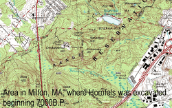
European explorers sailing the coastline noticed the bluish hue of the mountains, which is caused by the presence of riebeckite,[5] which gave area its modern name.[4] The name of the state of Massachusetts derives from the Massachusett Indian tribe's name of the hill: massa-adchu-es-et.[6] In 1893, the Metropolitan Parks Commission purchased the lands of Blue Hills Reservation as one of the state's first areas dedicated to public recreation.[4]
The practice of First Day Hikes to mark New Year's Day with an outdoor activity began in 1992 at Blue Hills Reservation.[7] By the 2010s, the idea had spread and such hikes were taking place in state parks nationwide.[7]
Flora and fauna
The ecology of the Blue Hills is diverse and includes marshes, swamps, upland and bottomland forests, meadows, and an Atlantic white cedar bog. A number of endangered species in Massachusetts, such as the timber rattlesnake, reside in the reservation. Other flora and fauna include dogwood, lady's slipper, white-tailed deer, coyotes, wild turkey, red fox, turkey vultures, and copperheads.[4]
Points of interest
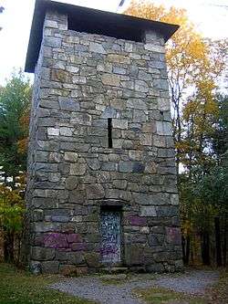
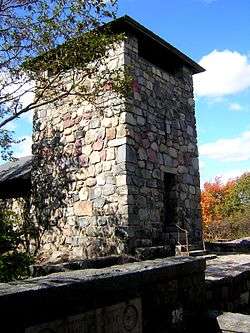
Features listed on the National Register of Historic Places
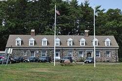
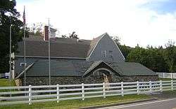
Blue Hills Trailside Museum
The Blue Hills Trailside Museum, which is affiliated with the Massachusetts Audubon Society, offers indoor and outdoor animal exhibits.[9]
Activities and amenities
Blue Hills Reservation is primarily used for hiking and mountain biking. It is also used for snowshoeing, downhill skiing, and cross country skiing during winter, and rock climbing (in certain areas) and horseback riding during permissible months. Between approximately December and March, Great Blue Hill offers a ski area. Houghton's Pond and nearby Ponkapoag Pond are popular swimming and recreation areas during the summer. Other recreational opportunities include non-motorized boating, camping, fishing, picnicking, playing fields, ice skating, and interpretive programs.
External links
|
|---|
| Coastal reservations | |
|---|
| River reservations | |
|---|
| Woodland reservations | |
|---|
| Heritage state parks | |
|---|
| Parkways and roads | |
|---|
|
|
|---|
|
|
|
|
|---|
Wildlife
Management Areas | |
|---|
Wildlife
Sanctuaries |
- Billingsgate Island
- Carr Island
- E. Howe Forbush
- Egg Rock
- Grace A. Robson
- J.C. Phillips
- Knight
- Penikese Island
- Ram Island (Salisbury)
- Ram Island (Mattapoisett)
- Susan B. Minns
- Tarpaulin Cove
- Watatic Mountain
|
|---|
|
|
|
|---|
- Black Pond Bog
- Boat Meadow
- Francis Newhall Woods
- Grassy Pond
- Greene Swamp
- Halfway Pond Island
- Hawley Bog
- Hockomock Swamp
- Hoft Farm
- Homer-Watcha Preserve
- Katama Plains
- McElwain-Olsen
- Miacomet Moors
- Reed Brook
- Drury
- Sandy Neck
- David H. Smith Preserve and Fire Trail
- Stacy Mountain
- Tatkon
|
|
|
|
|---|
- Allens Pond
- Arcadia
- Ashumet Holly
- Attleboro Springs
- Barnstable Great Marsh
- Blue Hills Trailside Museum
- Boston Nature Center
- Broad Meadow Brook
- Broadmoor
- Burncoat Pond
- Canoe Meadows
- Daniel Webster
- Drumlin Farm
- Eagle Lake
- Eastern Point
- Endicott
- Felix Neck
- Flat Rock
- Graves Farm
- Great Neck
- Habitat
- High Ledges
- Ipswich River
- Joppa Flats
- Kettle Island
- Lake Wampanoag
- Laughing Brook
- Lime Kiln Farm
- Lincoln Woods
- Long Pasture
- Lynes Woods
- Marblehead Neck
- Moose Hill
- Museum of American Bird Art
- Nahant Thicket
- Nashoba Brook
- North Hill Marsh
- North River
- Oak Knoll
- Pierpont Meadow
- Pleasant Valley
- Poor Farm Hill
- Richardson Brook
- Road's End
- Rough Meadows
- Rutland Brook
- Sampsons Island
- Sesachacha Heathlands
- Skunknett River
- Stony Brook
- Wachusett Meadow
- Waseeka
- Wellfleet Bay
- Wildwood Camp
|
|
|
|