History
The reservation was established in 1893 by the newly formed Metropolitan Parks Commission (later renamed the Metropolitan District Commission),[5] making it one of the first official nature preserves in Massachusetts, and one of five designed by the commission in that year.[6] Of these five, three were planned as woodland river reservations: the Mystic River Reservation, Charles River Reservation, and Neponset River Reservation.[5] The Mystic River Reservation originally comprised a little over 250 acres (100 ha) of land.[6] By the early 20th century, most of the land along the Mystic River in Medford, Arlington, and Somerville had become public (i.e. state-owned) land.[3][5]
In 2010, the DCR unveiled a plan for restoring and preserving the reservation, called the Mystic River Master Plan. Proposed projects included a partnership between the DCR and the City of Medford to restore the Condon Shell (an outdoor amphitheater located just outside Medford Square); restoration of the Amelia Earhart Dam basin parklands; and a $3.6 million federally funded link between the reservation, the Minuteman Bikeway, and the Alewife "T" Station.[3] The lower parkland is being redeveloped as part of Assembly Square construction.
Activities and amenities
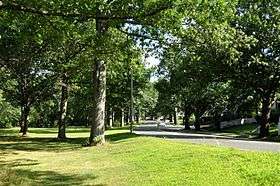
Facilities for field sports, picnicking, cycling, and sailing are found at four riverside parks: Draw Seven Park in Somerville, Torbert MacDonald Park in Medford, the Mystic Lakes in Winchester, Arlington, and Medford, and Mary O'Malley Waterfront Park in Chelsea.[4]
External links
|
|---|
|
|
|
|
|---|
Wildlife
Management Areas | |
|---|
Wildlife
Sanctuaries |
- Billingsgate Island
- Carr Island
- E. Howe Forbush
- Egg Rock
- Grace A. Robson
- J.C. Phillips
- Knight
- Penikese Island
- Ram Island (Salisbury)
- Ram Island (Mattapoisett)
- Susan B. Minns
- Tarpaulin Cove
- Watatic Mountain
|
|---|
|
|
|
|---|
- Black Pond Bog
- Boat Meadow
- Francis Newhall Woods
- Grassy Pond
- Greene Swamp
- Halfway Pond Island
- Hawley Bog
- Hockomock Swamp
- Hoft Farm
- Homer-Watcha Preserve
- Katama Plains
- McElwain-Olsen
- Miacomet Moors
- Reed Brook
- Drury
- Sandy Neck
- David H. Smith Preserve and Fire Trail
- Stacy Mountain
- Tatkon
|
|
|
|
|---|
- Allens Pond
- Arcadia
- Ashumet Holly
- Attleboro Springs
- Barnstable Great Marsh
- Blue Hills Trailside Museum
- Boston Nature Center
- Broad Meadow Brook
- Broadmoor
- Burncoat Pond
- Canoe Meadows
- Daniel Webster
- Drumlin Farm
- Eagle Lake
- Eastern Point
- Endicott
- Felix Neck
- Flat Rock
- Graves Farm
- Great Neck
- Habitat
- High Ledges
- Ipswich River
- Joppa Flats
- Kettle Island
- Lake Wampanoag
- Laughing Brook
- Lime Kiln Farm
- Lincoln Woods
- Long Pasture
- Lynes Woods
- Marblehead Neck
- Moose Hill
- Museum of American Bird Art
- Nahant Thicket
- Nashoba Brook
- North Hill Marsh
- North River
- Oak Knoll
- Pierpont Meadow
- Pleasant Valley
- Poor Farm Hill
- Richardson Brook
- Road's End
- Rough Meadows
- Rutland Brook
- Sampsons Island
- Sesachacha Heathlands
- Skunknett River
- Stony Brook
- Wachusett Meadow
- Waseeka
- Wellfleet Bay
- Wildwood Camp
|
|
|
|
|
|---|
| Coastal reservations | |
|---|
| River reservations | |
|---|
| Woodland reservations | |
|---|
| Heritage state parks | |
|---|
| Parkways and roads | |
|---|
|
