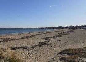
Quincy Shore Reservation is a public recreation area and protected shoreline on Quincy Bay, Boston Harbor, in Quincy, Massachusetts. Its primary attraction is a 2.3-mile-long (3.7 km) beach, accessible along its entire length by Quincy Shore Drive. The largest beach on Boston Harbor, it is known locally as Wollaston Beach, named for the adjacent Wollaston neighborhood.
The reservation is part of the Metropolitan Park System of Greater Boston and was established in 1899.[3] Also included in the reservation are Moswetuset Hummock, site of the first encounter of Plymouth Colony commander Myles Standish with the local native sachem, or leader, Chickatawbut in 1621 and cited as a source for the name of Massachusetts; and Caddy Park, a preserved salt marsh with nearby picnic facilities.[4]
External links
|
|---|
|
|
|
|
|---|
Wildlife
Management Areas | |
|---|
Wildlife
Sanctuaries |
- Billingsgate Island
- Carr Island
- E. Howe Forbush
- Egg Rock
- Grace A. Robson
- J.C. Phillips
- Knight
- Penikese Island
- Ram Island (Salisbury)
- Ram Island (Mattapoisett)
- Susan B. Minns
- Tarpaulin Cove
- Watatic Mountain
|
|---|
|
|
|
|---|
- Black Pond Bog
- Boat Meadow
- Francis Newhall Woods
- Grassy Pond
- Greene Swamp
- Halfway Pond Island
- Hawley Bog
- Hockomock Swamp
- Hoft Farm
- Homer-Watcha Preserve
- Katama Plains
- McElwain-Olsen
- Miacomet Moors
- Reed Brook
- Drury
- Sandy Neck
- David H. Smith Preserve and Fire Trail
- Stacy Mountain
- Tatkon
|
|
|
|
|---|
- Allens Pond
- Arcadia
- Ashumet Holly
- Attleboro Springs
- Barnstable Great Marsh
- Blue Hills Trailside Museum
- Boston Nature Center
- Broad Meadow Brook
- Broadmoor
- Burncoat Pond
- Canoe Meadows
- Daniel Webster
- Drumlin Farm
- Eagle Lake
- Eastern Point
- Endicott
- Felix Neck
- Flat Rock
- Graves Farm
- Great Neck
- Habitat
- High Ledges
- Ipswich River
- Joppa Flats
- Kettle Island
- Lake Wampanoag
- Laughing Brook
- Lime Kiln Farm
- Lincoln Woods
- Long Pasture
- Lynes Woods
- Marblehead Neck
- Moose Hill
- Museum of American Bird Art
- Nahant Thicket
- Nashoba Brook
- North Hill Marsh
- North River
- Oak Knoll
- Pierpont Meadow
- Pleasant Valley
- Poor Farm Hill
- Richardson Brook
- Road's End
- Rough Meadows
- Rutland Brook
- Sampsons Island
- Sesachacha Heathlands
- Skunknett River
- Stony Brook
- Wachusett Meadow
- Waseeka
- Wellfleet Bay
- Wildwood Camp
|
|
|
|
|
|---|
| Coastal reservations | |
|---|
| River reservations | |
|---|
| Woodland reservations | |
|---|
| Heritage state parks | |
|---|
| Parkways and roads | |
|---|
|