History
The park opened with 435 acres in 1970.[6] It was officially named in honor of local newspaperman Raymond J. Callahan by an act of the Massachusetts legislature in 1971.[7]
Flora and fauna
The park is home to a wide variety of trees both coniferous and deciduous. Wildlife include snapping turtles, spotted turtles, red bellied turtles, white tail deer, water snakes, tree frogs, most New England frog and toad varieties, minks, fisher cat, red fox, coyote, largemouth bass at Eagle Pond, various common trout, sunfish and blue gills, herons, egrets, bobolinks, goldfinches, orioles, red tail hawks, mocking birds, sparrows, swifts, swallows, grackles, cow birds, cat birds, barred owl, other various birds of prey, robins, cardinals, and blue jays. Deer flies, ticks, and mosquitoes are common. Garter snakes can be seen basking on dirt paths in spring and summer.
Activities and amenities
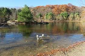
The park has 7 miles (11 km) of trails for hiking, mountain biking, cross-country skiing, and horseback riding.[5] Dog walking is a common activity.[8] The Bay Circuit Trail crosses through the park. Parking areas are situated on Millwood Street, Edmands Road, and Broadmeadow Road.[9]
References
- 1 2 "Richard Callahan State Park". Geographic Names Information System. United States Geological Survey.
- ↑ "Gibbs Mountain". Geographic Names Information System. United States Geological Survey.
- ↑ "2012 Acreage Listing" (PDF). Department of Conservation and Recreation. April 2012. Retrieved January 19, 2014.
- ↑ "Trail Map" (PDF). Callahan State Park. Executive Office of Energy and Environmental Affairs. Retrieved February 2, 2014.
- 1 2 "Callahan State Park". MassParks. Executive Office of Energy and Environmental Affairs. Retrieved February 2, 2014.
- ↑ Harris, Randy. "A Timeline of Framingham History". Framingham.com. Retrieved February 27, 2017.
- ↑ "Chapter 489" (PDF). Acts, 1971. Massachusetts Legislature. July 1, 1971. p. 343. Retrieved February 2, 2014.
- ↑ "Callahan State Park". Callahan Dog Owners Group. Retrieved April 10, 2017.
- ↑ "Callahan State Park". New England Mountain Bike Association. Retrieved April 10, 2017.
External links
|
|---|
|
|
|
|
|---|
Wildlife
Management Areas | |
|---|
Wildlife
Sanctuaries |
- Billingsgate Island
- Carr Island
- E. Howe Forbush
- Egg Rock
- Grace A. Robson
- J.C. Phillips
- Knight
- Penikese Island
- Ram Island (Salisbury)
- Ram Island (Mattapoisett)
- Susan B. Minns
- Tarpaulin Cove
- Watatic Mountain
|
|---|
|
|
|
|---|
- Black Pond Bog
- Boat Meadow
- Francis Newhall Woods
- Grassy Pond
- Greene Swamp
- Halfway Pond Island
- Hawley Bog
- Hockomock Swamp
- Hoft Farm
- Homer-Watcha Preserve
- Katama Plains
- McElwain-Olsen
- Miacomet Moors
- Reed Brook
- Drury
- Sandy Neck
- David H. Smith Preserve and Fire Trail
- Stacy Mountain
- Tatkon
|
|
|
|
|---|
- Allens Pond
- Arcadia
- Ashumet Holly
- Attleboro Springs
- Barnstable Great Marsh
- Blue Hills Trailside Museum
- Boston Nature Center
- Broad Meadow Brook
- Broadmoor
- Burncoat Pond
- Canoe Meadows
- Daniel Webster
- Drumlin Farm
- Eagle Lake
- Eastern Point
- Endicott
- Felix Neck
- Flat Rock
- Graves Farm
- Great Neck
- Habitat
- High Ledges
- Ipswich River
- Joppa Flats
- Kettle Island
- Lake Wampanoag
- Laughing Brook
- Lime Kiln Farm
- Lincoln Woods
- Long Pasture
- Lynes Woods
- Marblehead Neck
- Moose Hill
- Museum of American Bird Art
- Nahant Thicket
- Nashoba Brook
- North Hill Marsh
- North River
- Oak Knoll
- Pierpont Meadow
- Pleasant Valley
- Poor Farm Hill
- Richardson Brook
- Road's End
- Rough Meadows
- Rutland Brook
- Sampsons Island
- Sesachacha Heathlands
- Skunknett River
- Stony Brook
- Wachusett Meadow
- Waseeka
- Wellfleet Bay
- Wildwood Camp
|
|
|
|