Lamphun Province
| Lamphun ลำพูน | |||
|---|---|---|---|
| Province | |||
| |||
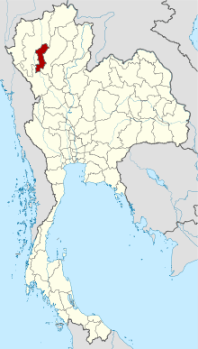 Map of Thailand highlighting Lamphun Province | |||
| Country | Thailand | ||
| Capital | Lamphun town | ||
| Government | |||
| • Governor | Wirachai Phuphiangchai (since October 2016) | ||
| Area | |||
| • Total | 4,506 km2 (1,740 sq mi) | ||
| Area rank | Ranked 49th | ||
| Population (2014) | |||
| • Total | 405,468[1] | ||
| • Rank | Ranked 60th | ||
| • Density rank | Ranked 48th | ||
| HDI | |||
| • HDI (2009) | 0.729 (medium) (43rd) | ||
| Time zone | UTC+7 (ICT) | ||
| Area code(s) | 053 | ||
| ISO 3166 code | TH-51 | ||
| Vehicle registration | ลำพูน | ||


Lamphun (Thai: ลำพูน, pronounced [lām.pʰūːn]) is one of the northern provinces (changwat) of Thailand. Neighboring provinces are (from north clockwise) Chiang Mai, Lampang, and Tak.
Geography
Lamphun is in the Ping River valley. It is surrounded by mountain chains, with the Thanon Thong Chai Range in the west and the Khun Tan Range in the east of the province. It is some 670 kilometres from Bangkok and 26 kilometres from Chiang Mai.
History
Under its old name of Haripunchai, Lamphun was the northernmost city of the Mon kingdom of the Dvaravati period,[2] and also the last to fall to the Thai. In the late-12th century it came under siege from the Khmer, but did not fall. However, in 1281 King Mengrai of Lanna finally seized the city, and made it part of his kingdom. After Burmese expansion in the 16th century, Lamphun was under Burmese rule for two centuries. In the 18th century, with the rise of Thonburi and Bangkok against Burmese rule, local leaders from Lampang agreed to be their allies. Lamphun was finally freed from the Burmese and ruled by relatives of Lampang's leader, gaining vassal status from Bangkok. Eventually, after the administrative reform of Bangkok government in the late-19th century, Lamphun became part, as a province, of Siam.[3]
Symbols
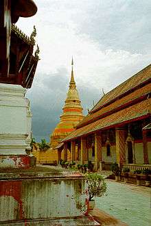
The provincial seal shows the temple Wat Phra That Haripunchai, which was already the main temple of the city Lamphun during Mon times. The gold-covered chedi is said to contain a relic of Buddha.
The provincial flower is the Flame of the Forest (Butea monosperma), and the provincial tree is the Rain Tree (Samanea saman).
Administrative divisions
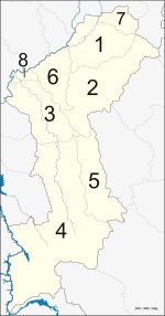
The province is divided into eight districts (amphoe). These are further subdivided into 51 sub-districts (tambon) and 551 villages (muban).
Municipal (thesaban) areas in the province are the town (thesaban mueang) Lamphun and 12 townships (thesaban tambon). The non-municipal area is administered by 45 tambon administrative arganizations (TAO) and two tambon councils.
For national elections the province is divided into three constituencies. Constituency 1 covers the Mueang District except Tambon Makhuea Chae, constituency 2 the districts Pa Sang, Mae Tha, and Tambon Makhuea Chae of Mueang District, and constituency 3 the districts Ban Hong, Thung Hua Chang, and Li.
Transport
- Air: Lamphun is served by Lamphun Airport.
- Rail: Lamphun's main station is Lamphun Railway Station.
Food
- Kaeng khae, a spicy curry consisting mainly of vegetables with chicken, frog, fish or snails.[4]
References
- ↑ "Population of the Kingdom" (PDF). Department of Provincial Affairs (DOPA) Thailand (in Thai). 2014-12-31. Retrieved 19 Mar 2015.
- ↑ "Historic Lamphun: Capital of the Mon Kingdom of Haripunchai", in: Forbes, Andrew, and Henley, David, Ancient Chiang Mai Volume 4. Chiang Mai, Cognoscenti Books, 2012. ASIN: B006J541LE
- ↑ "Archived copy". Archived from the original on 2007-01-29. Retrieved 2008-07-20.
- ↑ Lamphun food : Kaeng Khae Kai
External links

- Website of the province
- [http://www.tourismthailand.org/destinationguide/list.aspx?provinceid=39 Province page from the Tourist Authority of Thailand]
Places adjacent to Lamphun Province | ||||||||||
|---|---|---|---|---|---|---|---|---|---|---|
| ||||||||||