Ban Hong District
| Ban Hong บ้านโฮ่ง | |
|---|---|
| Amphoe | |
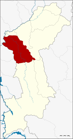 Amphoe location in Lamphun Province | |
| Coordinates: 18°19′52″N 98°49′8″E / 18.33111°N 98.81889°ECoordinates: 18°19′52″N 98°49′8″E / 18.33111°N 98.81889°E | |
| Country | Thailand |
| Province | Lamphun |
| Area | |
| • Total | 596.9 km2 (230.5 sq mi) |
| Population (2005) | |
| • Total | 42,697 |
| • Density | 71.5/km2 (185/sq mi) |
| Time zone | UTC+7 |
| Postal code | 51130 |
| Geocode | 5103 |
Ban Hong (Thai: บ้านโฮ่ง; IPA: [bâːn hôːŋ]) is a district (amphoe) of Lamphun Province, northern Thailand.
History
The minor district (king amphoe) Ban Hong was established in 1917, when it was split off from Pa Sang District. It was upgraded to a full district on 24 June 1956.[1]
Geography
Neighboring districts are (from the north clockwise): Wiang Nong Long, Pa Sang, Mae Tha, Thung Hua Chang and Li of Lamphun Province, Hot and Chom Thong of Chiang Mai Province .
Administration
The district is divided into five sub-district (tambon), which are further subdivided into 59 villages (muban). Ban Hong is a township (thesaban tambon) which covers parts of tambon Ban Hong. There are a further five tambon administrative organizations (TAO).
| No. | Name | Thai name | Villages | Pop. | |
|---|---|---|---|---|---|
| 1. | Ban Hong | บ้านโฮ่ง | 18 | 15,186 | |
| 2. | Pa Phlu | ป่าพลู | 12 | 7,758 | |
| 3. | Lao Yao | เหล่ายาว | 12 | 9,641 | |
| 4. | Si Tia | ศรีเตี้ย | 9 | 6,031 | |
| 5. | Nong Pla Sawai | หนองปลาสะวาย | 8 | 4,081 |
References
- ↑ พระราชกฤษฎีกาจัดตั้งอำเภอนาทวี อำเภอสะบ้าย้อย อำเภอคำชะอี อำเภอย่านตาขาว อำเภอวัดโบสถ์ อำเภอหนองบัว อำเภอวัฒนานคร อำเภอแสวงหา อำเภอท่าชนะ อำเภอพระพุทธบาท อำเภอโนนสัง อำเภอบำเหน็จณรงค์ อำเภอคอนสวรรค์ อำเภอบ้านโฮ่ง อำเภอคีรีมาศ อำเภอชนแดน อำเภอแม่แจ่ม อำเภอไทรน้อย และอำเภอบ้านแพง พ.ศ. ๒๔๙๙ (PDF). Royal Gazette (in Thai). 73 (46 ก): 657. June 5, 1956.
External links
- amphoe.com (Thai)
This article is issued from
Wikipedia.
The text is licensed under Creative Commons - Attribution - Sharealike.
Additional terms may apply for the media files.