Gero, Gifu
| Gero 下呂市 | |||
|---|---|---|---|
| City | |||
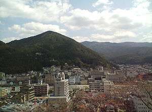 Gero Onsen | |||
| |||
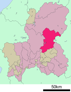 Location of Gero in Gifu Prefecture | |||
 Gero | |||
| Coordinates: 35°48′21.2″N 137°14′38.9″E / 35.805889°N 137.244139°ECoordinates: 35°48′21.2″N 137°14′38.9″E / 35.805889°N 137.244139°E | |||
| Country | Japan | ||
| Region | Chūbu | ||
| Prefecture | Gifu | ||
| Government | |||
| • Mayor | Makoto Nomura | ||
| Area | |||
| • Total | 851.21 km2 (328.65 sq mi) | ||
| Population (November 1, 2017) | |||
| • Total | 33,283 | ||
| • Density | 39/km2 (100/sq mi) | ||
| Time zone | UTC+9 (Japan Standard Time) | ||
| City symbols | |||
| - Tree | Maple[1] | ||
| - Flower | Satsuki azalea[1] | ||
| Phone number | 0576-24-2222 | ||
| Address | 960 Mori, Gero-shi, Gifu-ken, Japan 509-2202 | ||
| Website | Official website | ||


Gero (下呂市 Gero-shi) is a city located in Gifu, Japan. As of 31 October 2017, the city had an estimated population of 33283, and a population density of 39 persons per km2, in 12,253 households.[2] The total area of the city was 851.21 square kilometres (328.65 sq mi). The city is famous for its hot springs.
Geography
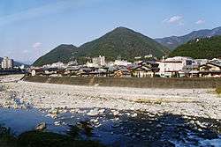
Gero is located in east-central Gifu Prefecture. The Hida River and the Maze River run throughout the city. Over 91% of the city area is covered by mountains and forest. Much of the city is within the borders of the Hida-Kisogawa Quasi-National Park. the volcano, Mount Ontake is located in Gero.
Climate
The city has a climate characterized by characterized by hot and humid summers, and mild winters (Köppen climate classification Cfa). The average annual temperature in Gero is 13.0 °C. The average annual rainfall is 2103 mm with September as the wettest month. The temperatures are highest on average in August, at around 26.0 °C, and lowest in January, at around 0.5 °C.[3]
Neighbouring municipalities
- Gifu Prefecture
- Nagano Prefecture
Demographics
Per Japanese census data,[4] the population of Gero has declined steadily over the past 40 years.
| Census Year | Population |
|---|---|
| 1970 | 44,254 |
| 1980 | 42,581 |
| 1990 | 41,576 |
| 2000 | 40,102 |
| 2010 | 36,314 |
History
The area around Gero was part of traditional Hida Province. During the Edo period, it was part of the tenryō controlled directly by the Tokugawa shogunate. During the post-Meiji restoration cadastral reforms, the area was organised into Mashita District, Gifu. The village of Gero of created on July 1, 1889 with the establishment of the modern municipalities system. It was raised to town status on January 1 1925. Gero merged with the towns of Hagiwara, Kanayama and Osaka, and the village of Maze (all from Mashita District) on March 1, 2004 to form the city of Gero.
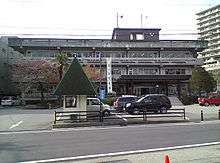
Government
Gero has a mayor-council form of government with a directly elected mayor and a unicameral city legislature of 14 members.
Economy
Gero's major industry is tourism. It is known throughout Japan for its onsen, which are mentioned even in the Nara period Shoku Nihongi. Gero has many hotels that can be visited by guests that are looking for accommodations near the hot springs. Large tubs are located in some hotels allowing couples to bathe together. Some hotels lend yukatas to the couples. It's not unusual to see people wearing yukatas on the streets and even in stores. Besides those in hotels, there are many inexpensive and convenient onsens located near railway stations, residential areas, and commercial centers up and down the valley. [5] Forestry and agriculture also play significant roles in the local economy.
Education
Gero has 13 public elementary schools and six public middle schools operated by the city government, and one public high school operated by the Gifu Prefectural Board of Education. The prefecture also operates two special education schools.
Transportation
Railway
- Hida-Kanayama - Yakeishi - Gero - Zenshōji - Hida-Hagiwara - Jōro - Hida-Miyada - Hida-Osaka
Highway
Sister city relations
International
Domestic
References
- 1 2 市章と市の花・木. Gero official webpage (in Japanese). Retrieved 10 August 2011.
- ↑ Official home page
- ↑ Gero climate data
- ↑ Gero population statistics
- ↑ "About Gero Onsen - Gifu Travel Guide | Planetyze". Planetyze. Retrieved 2017-10-19.
External links
![]()
![]()