Mount Ontake
| Mount Ontake Japan | |
|---|---|
| 御嶽山 | |
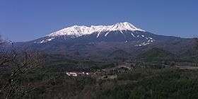 Viewed from Kuzo Pass of Route 361 | |
| Highest point | |
| Elevation | 3,067 m (10,062 ft) [1] |
| Prominence | 1,712 m (5,617 ft) [2] |
| Listing |
Ultra 100 famous mountains in Japan |
| Coordinates | 35°53′34″N 137°28′49″E / 35.89278°N 137.48028°ECoordinates: 35°53′34″N 137°28′49″E / 35.89278°N 137.48028°E [1] |
| Geography | |
 Mount Ontake Japan Japan | |
| Location | Gifu and Nagano, Chūbu region, Japan |
| Topo map | Geographical Survey Institute, 25000:1 御嶽山, 50000:1 御嶽山 |
| Geology | |
| Mountain type | Stratovolcano |
| Last eruption | September 2014 |
Mount Ontake (御嶽山 Ontake-san), also referred to as Mount Kiso Ontake (木曽御嶽山 Kiso Ontake-san), is the 14th highest mountain and second highest volcano in Japan (after Mount Fuji) at 3,067 m (10,062 ft).[3]
Description
Mt. Ontake is located around 100 km (62 mi) northeast of Nagoya, and around 200 km (125 mi) west of Tokyo, at the borders of Kiso and Ōtaki, Nagano Prefecture, and Gero, Gifu Prefecture.
The volcano has five crater lakes, with Ni no Ike (二ノ池) at 2,905 m (9,531 ft) being the highest mountain lake in Japan.
Ontake is a major sacred mountain, and following older shamanistic practices, actors and artists have gone to the mountain to put themselves into trances in order to get divine inspiration for their creative activities.[4]
Eruptions
Ontake was thought to be inactive until October 1979, when it underwent a series of explosive phreatic eruptions which ejected 200,000 tons of ash, and had a volcanic explosivity index (VEI) of 2.[5]
There were minor non-explosive (VEI 0) phreatic eruptions in 1991 and 2007.[5]
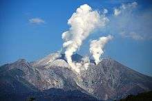
On Saturday, September 27, 2014, at around 11:53 a.m. Japan Standard Time (UTC +9),[6] the volcano erupted with a VEI of 3.[7][8] There were no significant earthquakes that might have warned authorities in the lead up to the phreatic eruption—caused by ground water flashing to steam in a hydrothermal explosion.[9] The Mount Ontake volcano eruption was an extremely rare phenomenon which made it difficult to take precautionary measures.[10][11] Sixty-three people were killed; five bodies remain un-recovered. The Japan Self-Defense Forces began carrying out helicopter searches for missing people after the eruption.[12]
See also
References
- 1 2 "Mountains altitude list in Japan(Gifu prefecture)" (in Japanese). Geospatial Information Authority of Japan. Retrieved December 18, 2010.
- ↑ "Japan Ultra-Prominences". Peaklist.org. Retrieved March 20, 2013.
- ↑ "On-take". Global Volcanism Program. Smithsonian Institution.
- ↑ Bernbaum, Edwin (1997). Sacred Mountains of the World. Berkeley & Los Angeles: University of California Press.
- 1 2 御嶽山 有史以降の火山活動 (in Japanese). Japan Meteorological Agency. Retrieved 2014-09-29.
- ↑ "御嶽山が噴火 火口から4キロ程度は警戒を". NHK. September 27, 2014. Archived from the original on September 27, 2014. Retrieved September 27, 2014.
- ↑ "御嶽山噴火、7人が灰に埋まる 山に残留44人 警察庁". Asahi Shimbun. Retrieved September 27, 2014.
- ↑ "3 buried under volcanic ash". NHK. Archived from the original on September 29, 2014. Retrieved September 27, 2014.
- ↑ "Experts warn of further eruptions". NHK. September 28, 2014. Archived from the original on October 2, 2014.
- ↑ "Why Japan missed volcano's warning signs". Nature: International Weekly Journal of Science. 29 September 2014.
- ↑ "Japan volcano Ontake an extremely rare eruption". Australian Geographic. 29 September 2014.
- ↑ "Japanese troops head for volcano after eruption to search for missing climbers". Chatham Daily News. Ontario. 27 September 2014. Retrieved 29 September 2014.
External links
| Wikimedia Commons has media related to Mount Ontake. |
- Ontakesan - Japan Meteorological Agency (in Japanese)
- "Ontakesan: National catalogue of the active volcanoes in Japan" (PDF). - Japan Meteorological Agency
- Ontakesan - Smithsonian Institution: Global Volcanism Program
| Hokkaidō | |||||||||
|---|---|---|---|---|---|---|---|---|---|
| Tōhoku region Jōshinetsu region |
| ||||||||
| Kantō region | |||||||||
| Chūbu region |
| ||||||||
| Western Japan | |||||||||
| |||||||||