Satpura Range
| Satpura Range | |
|---|---|
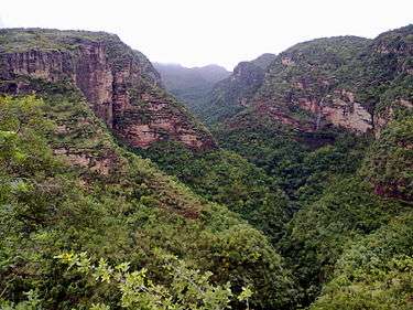 Pachmarhi valley | |
| Highest point | |
| Peak | Dhupgarh |
| Elevation | 1,350 m (4,430 ft) |
| Coordinates | 22°27′2″N 78°22′14″E / 22.45056°N 78.37056°E |
| Geography | |
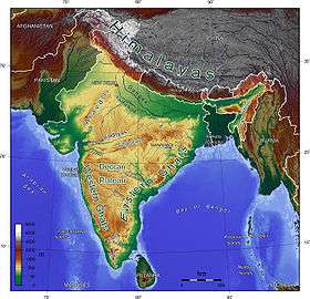 Topographic map of India showing the Satpura range in the Central region
| |
| Country |
|
| States | Madhya Pradesh, Maharashtra, Chhattisgarh and Gujarat |
| Range coordinates | 21°59′N 74°52′E / 21.983°N 74.867°ECoordinates: 21°59′N 74°52′E / 21.983°N 74.867°E |
| Rivers | Narmada, Mahanadi and Tapti |
| Geology | |
| Orogeny | a study |
The Satpura Range is a range of hills in central India. The range rises in eastern Gujarat state running east through the border of Maharashtra and Madhya Pradesh to the east till Chhattisgarh. The range parallels the Vindhya Range to the north, and these two east-west ranges divide Indian Subcontinent into the Indo-Gangetic plain of northern India and the Deccan Plateau of the south. The Narmada River originates from north-eastern end of Satpura and runs in the depression between the Satpura and Vindhya ranges, draining the northern slope of the Satpura range, running west towards the Arabian Sea. The Tapti River originates in the eastern-central part of Satpura, crossing the range in the center and running west at the range's southern slopes before meeting the Arabian Sea at Surat, draining the central and southern slopes of the range. The Godavari River and its tributaries drain the Deccan plateau, which lies south of the range, and the Mahanadi River drains the easternmost portion of the range. The Godavari and Mahanadi rivers flow into the Bay of Bengal. At its eastern end, the Satpura range meets the hills of the Chotanagpur Plateau. The Satpura Range is a horst mountain and is flanked by Narmada Graben in the north and much smaller but parallel Tapi Graben in the south.[1][2]
Etymology
Satpura is originally derived from Sanskrit word "Shatpura" (Devnagari: शतपुरा), which means "Hundred Mountains."
Geography
The eastern portion of the range receives more rainfall than the western portion, and the eastern range, together with the Eastern Ghats, constitute the eastern highlands moist deciduous forests ecoregion. The seasonally dry western portion of the range, together with the Narmada valley and the western Vindhya Range, are within the Narmada valley dry deciduous forests ecoregion.
The Narmada and the Tapti are major rivers that drain into the Arabian Sea. The Narmada originates in eastern Madhya Pradesh ( India) and flows west across the state, through a narrow valley between the Vindhya Range and spurs of the Satpura Range. It flows into the Gulf of Khambhat. The Tapi (also known as Tapti) follows a shorter, parallel course, between 80 and 160 kilometres (50 and 100 miles) south of the Narmada, flowing through the states of Maharashtra and Gujarat to drain into the Gulf of Khambhat.
Ecology
Most of the Satpura range was heavily forested; but the area has been subject to gradual deforestation in recent decades, although significant stands of forests remain. These forest enclaves provide habitat to several at risk and endangered species, including the Bengal tiger (Panthera tigris tigris), gaur (Bos gaurus), dhole (Cuon alpinus), sloth bear (Melursus ursinus), chousingha (Tetracerus quadricornis), and blackbuck (Antilope cervicapra).
However, Satpura is now famous for numerous tiger reserves. Once upon a time, it was ruled by wild Indian elephants and lions.[3]
Several protected areas have been earmarked in the area, including the Kanha, Pench, Gugamal and Satpura National Parks, Pachmarhi Biosphere Reserve, Melghat Tiger Reserve and the Bori Reserve Forest.
The Satpura Foundation, is a grass-roots organization that coordinates conservation efforts in the area, which continue to face challenges from development and infrastructure projects, logging and poaching.
Mythology
According to Harivamsa Purana 2.74.43 ff. there is an underground city of the Danavas (Daityas) under that mountain called "Satpur". Sri Krishna locked the doors of that city to prevent the Danavas (Daityas) to come out.
Tourism
The national parks, hill stations, reserves and towns in the Satpura range attract hundreds of thousands of visitors each year.
- Pachmarhi, a hill station in the range is located in Madhya Pradesh, has a number of attractions from its forests, animal reserve, rivers and rocky terrain. It is a tourist destination for trekking, fishing and adventure activities. It is also known as 'Queen of Satpura', and became a destination for Bollywood film shootings. The highest point of the Satpura range, Dhupgarh, is located in Pachmarhi.
- Satpura National Park is located in the district Hoshangabad of Madhya Pradesh. It gets its name from the Satpura ranges. It covers an area of 524 km2 (202 sq mi). Satpura National Park, and along with the adjoining Bori and Panchmarhi Sanctuaries, provides 1,427 km2 (551 sq mi) of unique central Indian highland ecosystem.The terrain of the national park is extremely rugged and consists of sandstone peaks, narrow gorges, ravines and dense forests. Satpura National Park, being part of a unique ecosystem, is very rich in biodiversity. The animals here are the tiger, Indian leopard, sambar, chital, Bhedki, nilgai, four-horned antelope, chinkara, bison (gour), wild boar, wild dog, bear, black buck, fox, porcupine, flying squirrel, mouse deer, Indian giant squirrel, etc. There are a variety of birds. Hornbills and peafowl are common birds found here. The flora consists of mainly sal, teak, tendu, Phyllanthus emblica, mahua, bel, bamboo, and grasses and medicinal plants.
- Kanha National Park is a national park and a tiger reserve near the range in Mandla and Balaghat districts of Madhya Pradesh, India. In the 1930s, Kanha area was divided into two sanctuaries, Hallon and Banjar, of 250 and 300 km2. Kanha National Park was created on 1 June 1955. Today it stretches over an area of 940 km2 in the two districts Mandla and Balaghat. Together with a surrounding buffer zone of 1,067 km2 and the neighboring 110 km2 Phen Sanctuary it forms the Kanha Tiger Reserve. Madhya Pradesh Forest Department. Retrieved 14 April 2010. This makes it the largest national park in Central India. The park has a significant population of royal Bengal tiger, leopards, the sloth bear, barasingha and Indian wild dog. The lush sal and bamboo forests, grassy meadows and ravines of Kanha provided inspiration to Rudyard Kipling for his famous novel "Jungle Book."
- Bori Wildlife Sanctuary, is located in Madhya Pradesh. Bori Wildlife Sanctuary includes India's oldest forest preserve, the Bori Reserve Forest, established in 1865 along the Tewa River. The sanctuary covers an area of 518 km2 (200 sq mi), located in the northern foothills of the Satpura Range. It is bounded by the Satpura National Park to the north and east, and by the Tawa River to the west. The sanctuary, together with Satpura National Park and the Pachmarhi Sanctuary, forms the Pachmarhi Biosphere Reserve. The sanctuary is mostly covered in mixed deciduous and bamboo forests, part of the eastern highlands moist deciduous forests ecoregion. It is an important transition zone between the forests of western and eastern India. Dominant trees include teak (Tectona grandis), dhaora (Anogeissus latifolia), tendu (Diospyros melanoxylon), among others. Large mammal species include tiger, leopard, wild boar, muntjac deer, gaur (Bos gaurus), chital deer (Axis axis), sambar (Cervus unicolor), and rhesus macaques.
- Bandhavgarh National Park, is one of the popular national parks in Madhya Pradesh located near satpura range in the Umaria district of Madhya Pradesh. Bandhavgarh was declared a national park in 1968, with an area of 105 km2. The buffer is spread over the forest divisions of Umaria and Katni and totals 437 km2. The park derives its name from the most prominent hillock of the area, which is said to be given by Hindu Lord Rama to his brother Lakshmana to keep a watch on Lanka (Ceylon). Hence the name Bandhavgarh (Sanskrit: Brother's Fort). This park has a large biodiversity. The density of the tiger population at Bandhavgarh is one of the highest known in India. The park has a large breeding population of leopards, and various species of deer. Maharaja Martand Singh of Rewa captured the first white tiger in this region in 1951. This white tiger, Mohan, is now stuffed and on display in the palace of the Maharajas of Rewa.
- Pench National Park is situated to the south of the Satpura. It is named after the name of the river Pench which flows through this area. This is the 19th project tiger reserve in India and was declared so in 1992. It has tropical moist deciduous forest. Meandering through the park from north to south. It is located on the southern boundary of Madhya Pradesh, bordering Maharashtra, in the districts of Seoni and Chhindwara. Pench National Park, comprising 758 km2 (293 sq mi), out of which a core area of 299 km2 (115 sq mi) of Indira Priyadarshini Pench National Park and the Mowgli Pench Sanctuary and remaining 464 km2 (179 sq mi) of the Pench national park is the buffer area. The area of the present tiger reserve has a glorious history. A description of its natural wealth and richness occurs in Ain-i-Akbari. Pench Tiger Reserve and its neighbourhood is the original setting of Rudyard Kipling's most famous work, The Jungle Book.
- Amarkantak is a pilgrim town in the state of Madhya Pradesh, India. Also called "Teerthraj" (the king of pilgrimages), Amarkantak region is a natural heritage area and is the meeting point of the Vindhyas and the Satpuras, with the Maikal Hills being the fulcrum. This is where the Narmada River, the Sone River and Johila River emerge.
- Chhindwara is one of the larger towns located in the Satpura range. It is situated on a plateau, surrounded by the lush green fields, rivers and sagaun trees. Chhindwara is surrounded by dense forest with diverse flora and fauna. Pench and Kanhan are two important rivers of Chhindwara. Chhindwara is an urban agglomeration and a municipality in Chhindwara district in the Indian state of Madhya Pradesh. It is the administrative headquarters of Chhindwara District. Chhindwara is reachable by rail or road from adjacent cities Nagpur and Jabalpur. The nearest airport is in Nagpur (130 km); however, a small airport (air-strip) is available at Chhindwara for landing charter aeroplanes/helicopters. The population of the District is 2,090,306, with a population growth rate of 13% and a male-to-female sex ratio of 0.966. The literacy rate is 100% .
- Toranmal is a hill retreat in Maharashtra. Its Gorakhnath Temple, dedicated to Lord Shiva and visited by thousands of devotees on Mahashivratri. Pilgrims often walk barefoot for days from surrounding areas in the Nandurbar district and across Maharashtra, Madhya Pradesh and Gujarat to make the yatra to Toranmal through Shahada.
- Chikhaldara is a hill retreat in Maharashtra located in Satpura ranges in Amravati District. It has a number of rivers, waterfalls, dense forests, rocks, mountains, trekking, and cool air. It has various viewing points such as Bhimkund waterfall, Devi point waterfall, Vairat point (highest point), Gavilgarh Fort, Prospect point, Mozari point, coffee garden, Panchbol point, etc. It is the only hill station in Vidharbha region of Maharashtra. Also it is the origin point of many river such as Pili, Chandrabhaga, Shahnoor, Bichhan, Sapan, Sipna, Dolar, Bholeshwari, etc.
- Melghat Tiger Reserve is a tiger reserve located in northern part of Amravati District of Maharashtra State in India. The Tapti River and the Gawilgadh ridge of the Satpura Range form the boundaries of the reserve. In 1985 Melghat Wildlife Sanctuary was created. The Tapi river (also known as Tapti river) flows through the northern end of the Melghat Tiger Reserve, through a forest which lies within the catchment area of the river system. Many different kinds of wildlife, both flora and fauna, are found here. And there many river flowing through the reservoir such as Sipna river, Khurshi River, Dolar river, Garga River, Khapra River, etc.
- Gugamal National Park is another national park located in Maharashtra and in Satpura range has an area of 1,673.93 km2 (646.31 sq mi). Built in 1974, this park is located in Chikhaldara and Dharni Tehsils of Amravati District, Maharashtra, India. It is part of Melghat Tiger Reserve. The forest in rugged and hilly area of Melghat is typical southern dry deciduous forest. This consist mainly of Tectona grandis, Ain, Tiwas, Aola, Lendia, Dhawada, Kusum are the important tree species. Bamboo is widely spread in the forests. There are some orchids and strobilanthes in the upper hills. The area is rich in medicinal plants. The area is rich in wild mammals including tiger, panther, sloth bear, wild dog, jackal, hyena, chousingha, sambar (largest deer) gaur, barking deer, ratel, flying squirrel, cheetal (a deer), nilgai, wild boar, langur, rhesus monkey, and macaque. Also found here are 25 types of fish and many varieties of butterfly. Crocodiles were re-introduced in a systematic manner in March 1990 and February 1991 in Siddu Kund in Gadga river near Dhakna and Hathikund in the Dolar river in the Gugamal National Park.
- Muktagiri is a Jain pilgrimage centre, located on border of Madhya Pradesh and Maharashtra in India. It comes under Bhainsdehi tehsil of Betul district or Baitul district in Madhya Pradesh, India. It is 14 km away from Paratwada, Dist. Amravati, Maharashtra. Muktagiri is 7 km away from Kharpi village on Paratwada - Baitul road. Muktagiri is also called as 'Mendhagiri'. There are 52 temples on the mountain, surrounding a waterfall. The waterfall is generally visible only when there is enough rainfall in the area. One can plan trip to Muktagiri between June to September to see the waterfall. A lot of monkeys can be seen near the 10th Temple – Bhagwan Sheetalnath temple – near which the waterfall is located. The 10th Temple is an ancient temple and is inside an ancient cave. The cave is prone to stonefall (which is generally said to happen only during night). Also, lot of honeybees are at a large distance from the cave. The 1st Temple, 10th Temple, 26th Temple and 40th Temple are the main temples.
- Shoolpaneshwar Wildlife Sanctuary, covering 607.70 km2 (234.63 sq mi), is located in Narmada district of Gujarat. It has 575 species of flowering plants, with vast patches of bamboo and it comprises a deciduous forest with semi-evergreen trees. Many type of animals like sloth bear, leopard, rhesus macaque, chausinga, barking deer, pangolin, herpetofauna, birds including Alexandrian parakeet are found here.
Other
INS Satpura (F48) is a Shivalik class frigate of the Indian Navy named for the range.
See also
References
- ↑ Valdiya, K. S. (2015-11-26). The Making of India: Geodynamic Evolution. Springer. ISBN 9783319250298.
- ↑ "Satpura Horst and Narmada–Tapi Grabens". 22. 2017-01-01: 237–247. doi:10.1016/B978-0-444-63971-4.00010-4. ISSN 0928-2025.
- ↑ "Archived copy". Archived from the original on 11 August 2013. Retrieved 11 August 2013.
External links

- satpuda.org
- ias.ac.in
