Kalpi
| Kalpi Kalpriyanagari | |
|---|---|
| Town | |
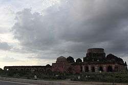 South facing view of Chaurasi Gumbad | |
 Kalpi  Kalpi | |
| Coordinates: 26°07′N 79°44′E / 26.12°N 79.73°ECoordinates: 26°07′N 79°44′E / 26.12°N 79.73°E | |
| Country | India |
| State | Uttar Pradesh |
| District | Jalaun |
| Founded by | Vasu Dev |
| Government | |
| • Type | Municipality |
| • Body | Kalpi Municipal Committee |
| • Chairman | Baikunthi devi |
| Elevation | 112 m (367 ft) |
| Population (2011) | |
| • Total | 51,670 |
| Languages | |
| • Official | Hindi |
| Time zone | UTC+5:30 (IST) |
| PIN | 285204[1] |
| Vehicle registration | UP |
| Website |
up |


Kalpi is a town and a municipal board in Jalaun district in the Indian state of Uttar Pradesh. It is on the right bank of the Yamuna.[2] It is situated 78 kilometre south-west of Kanpur from which it is connected by both road and rail.
History
Ancient
It is believed that the city was known as Kalap dev ki kalpi in the ancient times, later abbreviated to Kalpi. Kalpi is also known as the birthplace of Maharishi Veda vyas, the writer of Mahabharata and Puranas. He collected the chants of Vedas and assembled them in an arranged manner. Kalpi is said to have been founded by King Vasudeva at the end of the 4th century.
Medieval
In 1196 it fell to Qutb-ud-din Aybak, the viceroy of Mohammed Ghori, and during the subsequent Muslim period it played a significant part in the history of central India.[2] During Akbar's reign, Kalpi was a governor's seat and had a mint for copper coinage.[2] The witty Birbal of Akbar's court is considered to be born near this city.About the middle of the 18th century it passed into the hands of the Marathas.[2]
Modern

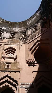
The town was captured by the British in 1803, and after 1806 remained in British possession[2] until India's independence in 1947. Kalpi was a part of Bundelkhand Agency, formed in 1811, and also housed its headquarters from 1818 to 1824. During this period the political agent to Governor General of India was appointed and headquartered in Kalpi. The British East India Company made it one of their principal stations for providing "commercial investment".[2] In May 1858 Hugh Rose (Lord Strathnairn) defeated here a force of Indian freedom fighters led by the Rani of Jhansi.[2] The fortified post of Kalpi, the former residence of the rulers of Jalaun State, was dismantled in 1860 by the British and its place was taken by a market known as Whiteganj.[3] There are many places for visiting like Vyas temple, Lanka Meenar, 84 Gumbaj and lots of Dargah like Khankah the Dargah of Sayyad Meer Tirmiji. Kalpi is also birthplace of Ved Vyas ji. There is a Kali Haveli and Rang Mahal of Beerbal that called Rang Mahal.
Geography
Kalpi is located at 26°07′N 79°44′E / 26.12°N 79.73°E.[4] It has an average elevation of 112 metres (367 feet).The climate in Kalpi is warm and temperate. The rainfall in Kalpi is significant, with precipitation even during the driest month.The temperature here averages 25.9 °C. The average annual rainfall is 892 mm.[5]
Location
.JPG)
The old town, which is on the Yamuna river has the ruin of a fort, and several temples of interest, while in the neighborhood are many ancient tombs.[2] Away from the river to the south-east is a lofty modern town ornamented with representations of the battles of the Ramayana.
Economy
Kalpi is still a centre of local trade (principally in grain, ghee and cotton) with a station on the North Central Railway (India) line from Jhansi to Kanpur, which crosses the Yamuna here.[2] In late 1970s and early 1980s Kalpi was one of the areas in central India affected by dacoits, and was frequented by the much dreaded Phoolan Devi gang.It has been declared an Industrial belt by the Government of India and handmade paper is produced there.
Transport
Railways
Kalpi is a major Railway Station of Kanpur-Jhansi railway section of North Central Railway.
.JPG)
Roadways
Kalpi lies on NH 27 on Kanpur-Jhansi section of National Highway. It is connected to cities of Kanpur, Jhansi and Orai by UPSRTC Buses at Kalpi Bus Station.
Airways
The nearest airport is at Kanpur near Chakeri (100 kilometres) which has flights to Delhi, Mumbai and Varanasi but is expected to be connected to major cities of India by 2019.
References
- ↑ "Kalpi Pincode 285204 STD code 05164".
- 1 2 3 4 5 6 7 8 9

- ↑ Great Britain India Office. The Imperial Gazetteer of India. Oxford: Clarendon Press, 1908.
- ↑ Falling Rain Genomics, Inc - Kalpi
- ↑ https://en.climate-data.org/location/767109/
External links
| Wikimedia Commons has media related to Kalpi. |