Harrison Township, Allegheny County, Pennsylvania
| Harrison Township | |
|---|---|
| Township | |
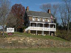 The Burtner Stone House, built in 1821, is along Burtner Road in Harrison Township. | |
 Location in Allegheny County and state of Pennsylvania | |
.svg.png) Location of Pennsylvania in the United States | |
| Coordinates: 40°37′36″N 79°43′29″W / 40.62667°N 79.72472°WCoordinates: 40°37′36″N 79°43′29″W / 40.62667°N 79.72472°W | |
| Country | United States |
| State | Pennsylvania |
| County | Allegheny |
| Government | |
| • Body | Board of Supervisors |
| • President | William Poston (unknown party) (Party Unknown) |
| Area[1] | |
| • Total | 7.89 sq mi (20.42 km2) |
| • Land | 7.36 sq mi (19.06 km2) |
| • Water | 0.53 sq mi (1.36 km2) |
| Population (2010) | |
| • Total | 10,461 |
| • Estimate (2016)[2] | 10,372 |
| • Density | 1,409.24/sq mi (544.08/km2) |
| Time zone | UTC-5 (EST) |
| • Summer (DST) | UTC-4 (EDT) |
| ZIP code | 15065 |
| Area code(s) | 724, 878 |
| FIPS code | 42-003-32832 |
| School district | Highlands |
| Website | http://harrisontwp.com/ |
Harrison Township is a township in Allegheny County in the U.S. state of Pennsylvania. The population was 10,461 at the 2010 census.[3] Pennsylvania Route 28 passes through Harrison Township connecting Kittanning to the northeast and Pittsburgh to the southwest. Allegheny Technologies has extensive steel mill facilities in Harrison Township, including its Allegheny Ludlum Brackenridge Works.[4][5] Harrison Township is located at the far northeast corner of Allegheny County. Its northern border is the Butler County line and the Allegheny River forms the township's eastern boundary with Westmoreland County. Its northeast corner also touches Armstrong County.
Geography
Harrison Township is located at 40°37′36″N 79°43′29″W / 40.62667°N 79.72472°W (40.626826, -79.724797).[6]
According to the United States Census Bureau, the township has a total area of 7.7 square miles (20 km2), of which 7.3 square miles (19 km2) is land and 0.5 square miles (1.3 km2), or 5.95%, is water.
Communities
There are several distinct sections of Harrison Township that form communities:
- Birdville
- Compton (Campton) [7]
- Karns
- Natrona (known as East Tarentum until 1862)
- West Natrona
- Natrona Heights
- Pleasantville
- Sligo, an unincorporated village—now a ghost town
Streams
- Little Bull Creek flows southwest through Harrison Township.[8]
- The entire course of Rachel Carson Run is within Harrison Township.[9] The stream forms a series of falls in Harrison Hills Park.
Demographics
| Historical population | |||
|---|---|---|---|
| Census | Pop. | %± | |
| 2010 | 10,461 | — | |
| Est. 2016 | 10,372 | [2] | −0.9% |
| U.S. Decennial Census[10] | |||
As of the census[11] of 2000, there were 10,934 people, 4,796 households, and 3,126 families residing in the township. The population density was 1,503.6 people per square mile (580.7/km²). There were 5,246 housing units at an average density of 721.4/sq mi (278.6/km²). The racial makeup of the township was 94.81% White, 3.69% Black or African American, 0.05% Native American, 0.41% Asian, 0.11% from other races, and 0.91% from two or more races. Hispanic or Latino of any race were 0.55% of the population.
There were 4,796 households, out of which 25.9% had children under the age of 18 living with them, 48.4% were married couples living together, 13.2% had a female householder with no husband present, and 34.8% were non-families. 31.7% of all households were made up of individuals, and 16.9% had someone living alone who was 65 years of age or older. The average household size was 2.27 and the average family size was 2.83.
In the township, the population was spread out, with 21.0% under the age of 18, 6.7% from 18 to 24, 26.6% from 25 to 44, 23.7% from 45 to 64, and 22.1% who were 65 years of age or older. The median age was 43 years. For every 100 females, there were 86.0 males. For every 100 females age 18 and over, there were 81.5 males.
The median income for a household in the township was $33,482, and the median income for a family was $42,309. Males had a median income of $36,743 versus $22,111 for females. The per capita income for the township was $18,011. About 9.6% of families and 11.4% of the population were below the poverty line, including 20.3% of those under age 18 and 8.1% of those age 65 or over.

Government and Politics
| Year | Republican | Democratic | Third Parties |
|---|---|---|---|
| 2016 | 55% 2,564 | 42% 1,967 | 4% 162 |
| 2012 | 51% 2,265 | 47% 2,089 | 2% 47 |
Museums and other points of interest
The Community Library of Allegheny Valley, Harrison Branch serves the township.[14]
Parks and recreation
Several parks are located throughout the township: Harrison Hills Park is a county park located in the northeast area of the township; the Natrona neighborhood has a community playground and riverfront park.
Education
Current buildings
Harrison Township is within the Highlands School District. Highlands High School (9–12), Highlands Middle School (6–8), the district's Buildings and Grounds Complex (maintenance), and Highlands School District administrative offices are in the township. Highlands Golden Rams Stadium (track and football), tennis courts, a soccer field, and the Highlands Community Center are adjacent to the middle school; and several baseball fields are next to the high school.
Former buildings
Historical schools, which are now closed, include: Natrona High School, later used for the Wood Street Elementary School (K–6), then sold and converted into apartments; Riverview Elementary School, used for the administrative offices since the early 1980s, slated to be sold after January 2012; and Birdville Elementary School, which was converted into the Citizens Hose Volunteer Fire Department. Heights Elementary School (K–5) was reassigned as the Heights Early Childhood Center (Kindergarten, the Pre-K Counts Program, Head Start, and the YMCA Before/After Childcare Program) in late June 2011; it closed in June 2012.
Taxes
School tax millage rate- The Highlands School District (shared with Brackenridge, Fawn Township, Harrison Township and Tarentum) in 2017 was 23.80. This ranked 14th highest/most expensive out of Allegheny County's 45 school districts [between Mt. Lebanon SD (13th highest) and Cornel SD (15th highest)].[15]
Notable natives and residents
- Leon Czolgosz, who assassinated U.S. President William McKinley on September 6, 1901. He lived in Natrona while a teenager, from 1889 until 1892.
References
- ↑ "2016 U.S. Gazetteer Files". United States Census Bureau. Retrieved Aug 13, 2017.
- 1 2 "Population and Housing Unit Estimates". Retrieved June 9, 2017.
- ↑ "Race, Hispanic or Latino, Age, and Housing Occupancy: 2010 Census Redistricting Data (Public Law 94-171) Summary File (QT-PL), Harrison township, Allegheny County, Pennsylvania". U.S. Census Bureau, American FactFinder 2. Retrieved September 27, 2011.
- ↑ "Process and Plant Capabilities at Brackenridge, Pennsylvania". Retrieved 2009-03-28.
- ↑ "Process and Plant Capabilities at Natrona, Pennsylvania". Retrieved 2009-03-28.
- ↑ "US Gazetteer files: 2010, 2000, and 1990". United States Census Bureau. 2011-02-12. Retrieved 2011-04-23.
- ↑ "Compton". Geographic Names Information System. United States Geological Survey. Retrieved 2010-04-30.
- ↑ "Little Bull Creek". Geographic Names Information System. United States Geological Survey. Retrieved 2009-11-25.
- ↑ "Rachel Carson Run". Geographic Names Information System. United States Geological Survey. Retrieved 2011-03-15.
- ↑ "Census of Population and Housing". Census.gov. Retrieved June 4, 2016.
- ↑ "American FactFinder". United States Census Bureau. Retrieved 2008-01-31.
- ↑ EL. "2012 Allegheny County election". Pittsburgh Tribune-Review. Retrieved 15 October 2017.
- ↑ EL. "2016 Pennsylvani general election..." Pittsburgh Post-Gazette. Retrieved 15 October 2017.
- ↑ "Community Library of Allegheny Valley". Retrieved 2010-08-11.
- ↑ EL. "Allegheny County Treasurer". Retrieved 1 September 2017.
External links
| Wikimedia Commons has media related to Harrison Township, Allegheny County, Pennsylvania. |
| Counties |  Map of the Pittsburgh Tri-State with green counties in the metropolitan area and yellow counties in the combined area. | |
|---|---|---|
| Major cities | ||
| Cities and towns 15k-50k (in 2010) | ||
| Airports | ||
| Topics | ||
| ||