Verona, Pennsylvania
| Verona | |
|---|---|
| Borough | |
 | |
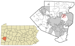 Location in Allegheny County and the U.S. state of Pennsylvania. | |
| Coordinates: 40°30′18″N 79°50′27″W / 40.50500°N 79.84083°WCoordinates: 40°30′18″N 79°50′27″W / 40.50500°N 79.84083°W | |
| Country | United States |
| State | Pennsylvania |
| County | Allegheny |
| Settled | 1769 |
| Incorporated | 1871 |
| Government | |
| • Mayor | David Ricupero (D) |
| Area[1] | |
| • Total | 0.60 sq mi (1.54 km2) |
| • Land | 0.51 sq mi (1.31 km2) |
| • Water | 0.09 sq mi (0.24 km2) |
| Population (2010) | |
| • Total | 2,474 |
| • Estimate (2016)[2] | 2,419 |
| • Density | 4,790.10/sq mi (1,849.45/km2) |
| Time zone | UTC-5 (Eastern (EST)) |
| • Summer (DST) | UTC-4 (EDT) |
| ZIP codes | 15147 |
| Area code(s) | 412 |
| FIPS code | 42-80032 |
| Website | Borough of Verona |
Verona is a borough in Allegheny County, Pennsylvania, in the United States. It is 13 miles (21 km) northeast of downtown Pittsburgh, along the left bank of the Allegheny River. As of the 2010 census it had a population of 2,474.[3]
History
Verona was named by combining the names of the Verner and Iona railroad stops along the Allegheny Valley Railroad.[4] James Verner was town's founder.[5]
Industry
Formerly, railroad shops, tool works, lumber yards, steel-casting works, structural iron works, and a chemical plant operated in the borough. Woodings-Verona Tool Works, Inc. once produced tools in the borough along Jones Street. Producing Daily's cocktail mixes and Little Hugs, American Beverage Corporation currently has a large-scale production facility where the train roundhouse once stood next to Plum Creek. Bunting Graphics, Inc. also has operation in Verona. Bunting Graphics has supplied signage and architecture around the world, including for the National Parks System. In 1900, the number of people living in Verona was 1,904; the population increased to 2,849 in 1910. The population was 2,474 at the 2010 census.
Education
Verona is served by the Riverview School District.
Government and Politics
| Year | Republican | Democratic | Third Parties |
|---|---|---|---|
| 2016 | 42% 475 | 56% 632 | 2% 21 |
| 2012 | 40% 405 | 59% 603 | 1% 17 |
Taxes
School tax millage rate- The Riverview School District (shared with Oakmont borough and Verona borough) in 2017 was 23.01. This ranked 17th highest/most expensive out of Allegheny County's 45 school districts [between Shaler SD (16th highest) and Elizabeth-Forward SD (18th highest)].[8]
Geography
Verona is located at 40°30′18″N 79°50′27″W / 40.50500°N 79.84083°W (40.504882, -79.840935).[9]
According to the United States Census Bureau, the borough has a total area of 0.6 square miles (1.6 km2), of which 0.5 square miles (1.3 km2) is land and 0.1 square miles (0.26 km2), or 14.29%, is water.
Streams
Plum Creek flows through the borough.[10]
Surrounding communities
Verona is bordered by Oakmont to the north and Penn Hills Township to the east and south. To the west, across the Allegheny River, is O'Hara Township.
Demographics
| Historical population | |||
|---|---|---|---|
| Census | Pop. | %± | |
| 1880 | 1,599 | — | |
| 1890 | 1,477 | −7.6% | |
| 1900 | 1,904 | 28.9% | |
| 1910 | 2,849 | 49.6% | |
| 1920 | 3,938 | 38.2% | |
| 1930 | 4,376 | 11.1% | |
| 1940 | 4,396 | 0.5% | |
| 1950 | 4,325 | −1.6% | |
| 1960 | 4,032 | −6.8% | |
| 1970 | 3,737 | −7.3% | |
| 1980 | 3,179 | −14.9% | |
| 1990 | 3,260 | 2.5% | |
| 2000 | 3,124 | −4.2% | |
| 2010 | 2,474 | −20.8% | |
| Est. 2016 | 2,419 | [2] | −2.2% |
| Sources:[11][12][13][14][15][16] | |||
As of the census[15] of 2000, there were 3,124 people, 1,376 households, and 806 families residing in the borough. The population density was 5,841.0 people per square mile (2,275.8/km²). There were 1,480 housing units at an average density of 2,767.2 per square mile (1,078.2/km²). The racial makeup of the borough was 95.77% White, 3.07% African American, 0.13% Native American, 0.35% Asian, 0.16% from other races, and 0.51% from two or more races. Hispanic or Latino of any race were 0.32% of the population.
There were 1,376 households, out of which 28.6% had children under the age of 18 living with them, 36.8% were married couples living together, 16.3% had a female householder with no husband present, and 41.4% were non-families. 36.8% of all households were made up of individuals, and 16.2% had someone living alone who was 65 years of age or older. The average household size was 2.26 and the average family size was 2.98.
In the borough the population was spread out, with 23.9% under the age of 18, 8.1% from 18 to 24, 29.0% from 25 to 44, 21.4% from 45 to 64, and 17.6% who were 65 years of age or older. The median age was 39 years. For every 100 females there were 91.3 males. For every 100 females age 18 and over, there were 85.0 males.
The median income for a household in the borough was $28,245, and the median income for a family was $36,452. Males had a median income of $26,890 versus $25,462 for females. The per capita income for the borough was $15,881. About 10.0% of families and 14.1% of the population were below the poverty line, including 21.9% of those under age 18 and 16.6% of those age 65 or over.
References
- ↑ "2016 U.S. Gazetteer Files". United States Census Bureau. Retrieved Aug 13, 2017.
- 1 2 "Population and Housing Unit Estimates". Retrieved June 9, 2017.
- ↑ "Race, Hispanic or Latino, Age, and Housing Occupancy: 2010 Census Redistricting Data (Public Law 94-171) Summary File (QT-PL), Verona borough, Pennsylvania". U.S. Census Bureau, American FactFinder 2. Archived from the original on September 11, 2013. Retrieved September 26, 2011.
- ↑ Barr, H; Zaccaria, E.; Reed, G. (1971). A Verona Album, 1871-1971. Verona Centennial Book Committee. p. 5.
- ↑ Porter, Thomas J. Jr. (May 10, 1984). "Town names carry a little bit of history". Pittsburgh Post-Gazette. p. 1. Retrieved 26 May 2015.
- ↑ EL. "2012 Allegheny County election". Pittsburgh Tribune-Review. Retrieved 15 October 2017.
- ↑ EL. "2016 Pennsylvani general election..." Pittsburgh Post-Gazette. Retrieved 15 October 2017.
- ↑ EL. "Allegheny County Treasurer". Retrieved 1 September 2017.
- ↑ "US Gazetteer files: 2010, 2000, and 1990". United States Census Bureau. 2011-02-12. Retrieved 2011-04-23.
- ↑ "Plum Creek". Geographic Names Information System. United States Geological Survey. Retrieved 2010-12-18.
- ↑ "Population-Pennsylvania" (PDF). U.S. Census 1910. U.S. Census Bureau. Retrieved 22 November 2013.
- ↑ "Number and Distribution of Inhabitants:Pennsylvania-Tennessee" (PDF). Fifteenth Census. U.S. Census Bureau.
- ↑ "Number of Inhabitants: Pennsylvania" (PDF). 18th Census of the United States. U.S. Census Bureau. Retrieved 22 November 2013.
- ↑ "Pennsylvania: Population and Housing Unit Counts" (PDF). U.S. Census Bureau. Retrieved 22 November 2013.
- 1 2 "American FactFinder". United States Census Bureau. Archived from the original on September 11, 2013. Retrieved 2008-01-31.
- ↑ "Annual Estimates of the Resident Population". U.S. Census Bureau. Archived from the original on 2 June 2013. Retrieved 22 November 2013.
| Counties |  Map of the Pittsburgh Tri-State with green counties in the metropolitan area and yellow counties in the combined area. | |
|---|---|---|
| Major cities | ||
| Cities and towns 15k-50k (in 2010) | ||
| Airports | ||
| Topics | ||
| ||