Greenwood–Afton Rural Historic District
|
Greenwood-Afton Rural Historic District | |
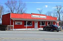 Afton church and post office | |
  | |
| Location | Roughly 5 miles (8.0 km) to 7 miles (11 km) north and south of I-64, near Greenwood, Virginia |
|---|---|
| Coordinates | 38°03′21″N 78°46′12″W / 38.05583°N 78.77000°WCoordinates: 38°03′21″N 78°46′12″W / 38.05583°N 78.77000°W |
| Area | 16,300 acres (6,600 ha) |
| NRHP reference # |
11000258[1] (original) 15001053 (increase) |
| VLR # | 002-5075 |
| Significant dates | |
| Added to NRHP | May 6, 2011 |
| Boundary increase | February 8, 2016 |
| Designated VLR | December 16, 2010[2] |
Greenwood-Afton Rural Historic District is a national historic district located at Greenwood, Albemarle County, Virginia. The district encompasses 839 contributing buildings, 55 contributing sites, 68 contributing structures, and 2 contributing objects. The district is characterized by large farms, historic villages, and crossroads communities. Ten properties are separately listed on the National Register of Historic Places.[3]
It was added to the National Register of Historic Places in 2011,[1] and enlarged by the addition of two properties in 2016.
See also
References
- 1 2 "National Register of Historic Places Listings". Weekly List of Actions Taken on Properties: 5/02/11 through 5/06/11. National Park Service. 2011-05-13.
- ↑ "Virginia Landmarks Register". Virginia Department of Historic Resources. Retrieved 2013-05-12.
- ↑ Jennifer Hallock and Gardiner Hallock (September 2010). "National Register of Historic Places Inventory/Nomination: Greenwood-Afton Rural Historic District" (PDF). and Accompanying four photos


This article is issued from
Wikipedia.
The text is licensed under Creative Commons - Attribution - Sharealike.
Additional terms may apply for the media files.