Coney Island Avenue

Coney Island Avenue is a roadway in the New York City borough of Brooklyn that runs north-south for a distance of roughly five miles, almost parallel to Ocean Parkway and Ocean Avenue. It begins at Brighton Beach Avenue in Coney Island and goes north to Park Circle at the southwest corner of Prospect Park, where it becomes Prospect Park Southwest. Near-parallel Ocean Parkway terminates five blocks south and three blocks west of that intersection, becoming the Prospect Expressway (New York State Route 27). Ocean Parkway originally extended north to Park Circle, where Coney Island Avenue meets Prospect Park, until construction of the Prospect Expressway replaced the northern half-mile of Ocean Parkway but included ramps to the edge of Prospect Park.
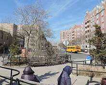
Coney Island Avenue frontage is dominated by mixed-use housing: pre-war apartment buildings, small shops, including a large number of antique shops, and service businesses. The B68 bus line runs along Coney Island Avenue, connecting the Prospect Park area and Downtown Brooklyn to the famous oceanfront attractions of Coney Island and Brighton Beach.
The area surrounding a roughly one-mile stretch of Coney Island Avenue is home to a sizable population of Pakistani Americans, occasioning the informal name "Little Pakistan".[1]
References
- ↑ "The Coney Island of Their Mind". The New York Times. Retrieved 2012-03-14.
External links
- Coney Island Plank Road Forgotten-NY
Coordinates: 40°36′44.56″N 73°57′46.11″W / 40.6123778°N 73.9628083°W