Kissena Boulevard
Route map:
Kissena Blvd | |
|---|---|
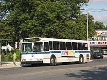 The Q25 bus traveling northboun on Kissena Boulevard in Kew Gardens Hills | |
| Owner | City of New York |
| Maintained by | NYCDOT |
| Length | 2.7 mi[1] (4.3 km) |
| Location | Queens, New York City |
| South end | Parsons Boulevard / 75th Avenue in Kew Gardens Hills |
| Major junctions |
|
| North end | Main Street in Flushing |
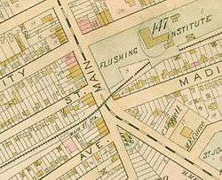
Kissena Boulevard is a thoroughfare spanning the central neighborhoods of the borough of Queens in New York City, extending from Main Street in the Flushing Chinatown to Parsons Boulevard in Kew Gardens Hills. The road's name is derived from Kissena Lake, a name given by 19th century horticulturist Samuel Bowne Parsons for the Chippewa word meaning, "it is cold". The lake is located in Kissena Park.
The road is one of the oldest in Queens, a 4-mile path connecting the colonial settlements of Flushing and Jamaica, known originally as the "Road to Jamaica" and later Jamaica Avenue. After Queens was consolidated into the City of New York in 1898, the undeveloped sections of the borough were subdivided into a street grid. The section of the Road to Jamaica below 75th Avenue was absorbed into Parsons Boulevard and much of the north-south traffic between Flushing and Jamaica was taken by newly created Main Street. Kissena Boulevard serves as a diagonal route connecting Main Street with Parsons Boulevard. The boulevard is only 2 lanes wide for the majority of its run, but becomes 4 lanes wide with a median divider between the Long Island Expressway (LIE) and 71st Avenue. Additionally, Queens College borders the boulevard to the west, south of the LIE.
Landmarks along the route include Kissena Park, Queens College, and Pomonok Houses. A branch of the Queens Library is also on Kissena Boulevard.
Transportation
Kissena Boulevard is covered by the Q25 and Q34 MTA Bus routes for its entire length.[2] The Q17 runs along Kissena Boulevard between Main Street and Long Island Expressway. Also, the Q27 runs along Kissena Boulevard between Main Street and Holly Avenue.[3] The Flushing Main Street station on the Long Island Rail Road is at the boulevard's northern end. Kissena Boulevard is also where KISS guitarist Paul Stanley got the idea for his band's name, according to Lydia Criss, former wife of KISS drummer Peter Criss.
References
- ↑ Google (July 1, 2018). "Kissena Boulevard" (Map). Google Maps. Google. Retrieved July 1, 2018.
- ↑ MTA Regional Bus Operations. "Q25/Q34 bus schedule" (PDF).
- ↑ MTA Regional Bus Operations. "Q17 bus schedule" (PDF).